Colombia, Huila

Last updated
Colombia, Huila
Municipality and town
Santa Ana Colombia-Huila.jpg
Flag of Colombia (Huila).svg
Escudo de Colombia (Huila).svg
Colombia - Huila - Colombia.svg
Location of the municipality and town of Colombia, Huila in the Huila Department of Colombia.
CountryFlag of Colombia.svg  Colombia
Department Huila Department
Area
[1]
  Total1,538 km2 (594 sq mi)
Population
 (Census 2018 [2] )
  Total7,040
  Density4.6/km2 (12/sq mi)
Time zone UTC-5 (Colombia Standard Time)

Colombia is a town and municipality in the Huila Department, Colombia.

Climate

Climate data for Colombia (Sta Ana), elevation 1,410 m (4,630 ft), (1981–2010)
MonthJanFebMarAprMayJunJulAugSepOctNovDecYear
Mean daily maximum °C (°F)26.0
(78.8)
26.0
(78.8)
25.4
(77.7)
24.9
(76.8)
24.4
(75.9)
24.3
(75.7)
24.4
(75.9)
25.3
(77.5)
25.9
(78.6)
25.6
(78.1)
24.7
(76.5)
25.1
(77.2)
25.2
(77.4)
Daily mean °C (°F)20.1
(68.2)
20.3
(68.5)
20.1
(68.2)
19.9
(67.8)
19.8
(67.6)
19.3
(66.7)
19.2
(66.6)
19.7
(67.5)
20.0
(68.0)
20.0
(68.0)
19.8
(67.6)
19.9
(67.8)
19.8
(67.6)
Mean daily minimum °C (°F)15.7
(60.3)
16.0
(60.8)
16.4
(61.5)
16.5
(61.7)
16.3
(61.3)
15.5
(59.9)
15.1
(59.2)
15.2
(59.4)
15.7
(60.3)
15.9
(60.6)
16.3
(61.3)
15.9
(60.6)
15.9
(60.6)
Average precipitation mm (inches)63.9
(2.52)
62.9
(2.48)
113.5
(4.47)
111.7
(4.40)
107.3
(4.22)
60.9
(2.40)
60.9
(2.40)
36.7
(1.44)
54.7
(2.15)
133.6
(5.26)
155.7
(6.13)
83.7
(3.30)
1,034
(40.7)
Average precipitation days101016181917161114192014182
Average relative humidity (%)80808283848482797780838181
Source: Instituto de Hidrologia Meteorologia y Estudios Ambientales [3]
Climate data for Colombia (Legiosa La), elevation 1,476 m (4,843 ft), (1981–2010)
MonthJanFebMarAprMayJunJulAugSepOctNovDecYear
Mean daily maximum °C (°F)23.6
(74.5)
24.1
(75.4)
23.4
(74.1)
22.9
(73.2)
22.8
(73.0)
21.2
(70.2)
20.9
(69.6)
21.7
(71.1)
23.1
(73.6)
23.8
(74.8)
23.5
(74.3)
23.6
(74.5)
22.8
(73.0)
Daily mean °C (°F)19.5
(67.1)
19.6
(67.3)
19.5
(67.1)
19.3
(66.7)
18.9
(66.0)
18.0
(64.4)
17.6
(63.7)
18.2
(64.8)
19.0
(66.2)
19.3
(66.7)
19.3
(66.7)
19.3
(66.7)
18.9
(66.0)
Mean daily minimum °C (°F)16.3
(61.3)
16.7
(62.1)
16.8
(62.2)
16.7
(62.1)
16.4
(61.5)
15.9
(60.6)
15.3
(59.5)
15.6
(60.1)
16.0
(60.8)
16.3
(61.3)
16.4
(61.5)
16.3
(61.3)
16.2
(61.2)
Average precipitation mm (inches)68.7
(2.70)
87.1
(3.43)
133.7
(5.26)
202.1
(7.96)
272.0
(10.71)
322.1
(12.68)
330.7
(13.02)
247.3
(9.74)
168.0
(6.61)
163.8
(6.45)
187.8
(7.39)
106.0
(4.17)
2,289.2
(90.13)
Average precipitation days121319252827272623242519266
Average relative humidity (%)82828486858686848282858384
Mean monthly sunshine hours 164.3132.7105.493.093.072.086.8111.6138.0136.4126.0148.81,408
Mean daily sunshine hours 5.34.73.43.13.02.42.83.64.64.44.24.83.9
Source: Instituto de Hidrologia Meteorologia y Estudios Ambientales [3]

Related Research Articles

<span class="mw-page-title-main">Puerto Boyacá</span> Municipality and town in Boyacá Department, Colombia

Puerto Boyacá is a Colombian river-port town and municipality by the Magdalena River in the Boyacá Department, where is also considered a Special Trade Zone due to its port status. Its main industries are oil exploration and processing. In the 1980s and early 1990s, Puerto Boyacá was affected intensively by the Colombian Armed Conflict.

<span class="mw-page-title-main">Venecia, Antioquia</span> Municipality and town in Antioquia Department, Colombia

Venecia is a town and municipality in Antioquia Department, Colombia. According to the 2018 census, the population comprised 10,280 people.

<span class="mw-page-title-main">San Carlos, Antioquia</span> Municipality and town in Antioquia Department, Colombia

San Carlos is a town and municipality in the Colombian department of Antioquia, part of the subregion of Eastern Antioquia. It is called the hydro-electrical capital of Colombia, because it has many dams and it produces much energy. The population was 14,480 at the 2018 census.

<span class="mw-page-title-main">Atrato</span> Municipality and town in Chocó Department, Colombia

Atrato is a municipality and town in the Chocó Department near the Pacific Ocean, Colombia.

<span class="mw-page-title-main">Algarrobo, Magdalena</span> Town in Caribbean, Colombia

Algarrobo is a town and municipality of the Magdalena Department in northern Colombia. Founded in 1895 by José Felipe Oñate. Erected municipality by ordinance 008 of June 24, 1999.

<span class="mw-page-title-main">Sabanas de San Ángel</span> Town in Caribbean, Colombia

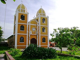
Sabanas de San Ángel, Spanish for Savannas of Saint Angel, is a town and municipality of the Colombian Department of Magdalena. Founded around 1607 with the name San Antoñito by the Spanish Colonizers as a pathway town in the route between La Guajira Department and the Magdalena River. On June 24, 1999 the municipality is created with the name of Sabanas de San Angel that segregated from the municipalities of Ariguaní, Pivijay, Chibolo and Plato.

<span class="mw-page-title-main">San Sebastián de Buenavista</span> Town in Caribbean, Colombia

San Sebastián de Buenavista is a town and municipality of the Colombian Department of Magdalena. Founded in 1748 by Fernando de Mier y Guerra with the name San Sebastián de Melchiquejo, but was later changed on November 15, 1957 when it was erected municipality.

<span class="mw-page-title-main">Pinto, Magdalena</span> Town in Caribbean, Colombia

Pinto or Santa Bárbara de Pinto is a town and municipality of the Magdalena Department in northern Colombia.

<span class="mw-page-title-main">Pijiño</span> Town in Caribbean, Colombia

Pijiño or Pijiño del Carmen is a town and municipality of the Magdalena Department in northern Colombia.

<span class="mw-page-title-main">Tenerife, Magdalena</span> Town in Caribbean, Colombia

Tenerife is a town and municipality of the Magdalena Department in northern Colombia.

<span class="mw-page-title-main">Manatí, Atlántico</span> Municipality and town in Caribbean, Colombia

Manatí is a Colombian municipality located to the south of the Atlántico department, approximately 44 miles from Barranquilla. It was created in 1639 in a place the natives used to call Mahabana. Its current population according to the latest DANE's census is 13.456 people.

<span class="mw-page-title-main">Soledad, Atlántico</span> Place in Caribbean, Colombia

Soledad is a municipality in the Colombian department of Atlántico, part of the Metropolitan area of Barranquilla. It is 6th in population in Colombia and 3rd in the Caribbean region, after Barranquilla and Cartagena. It is also the city with the highest population growth in Colombia and in 2005 was 455,734 and 2019 683,486. On October 29, 2023, Alcira Sandoval Ibañez was elected by popular vote as the new mayor of Soledad.

<span class="mw-page-title-main">Hatillo de Loba</span> Municipality and town in Bolívar Department, Colombia

Hatillo de Loba is a town and municipality located in the Bolívar Department, northern Colombia.

<span class="mw-page-title-main">Pinillos</span> Municipality and town in Bolívar Department, Colombia

Pinillos is a town and municipality located in the Bolívar Department, northern Colombia.

<span class="mw-page-title-main">San Fernando, Bolívar</span> Municipality and town in Bolívar Department, Colombia

San Fernando is a town and municipality located in the Bolívar Department, northern Colombia.

<span class="mw-page-title-main">Talaigua Nuevo</span> Municipality and town in Bolívar Department, Colombia

Talaigua Nuevo is a town and municipality located in the Bolívar Department, northern Colombia.

<span class="mw-page-title-main">San Pedro, Sucre</span> Municipality and town in Sucre Department, Colombia

San Pedro is a town and municipality located in the Sucre Department, northern Colombia.

<span class="mw-page-title-main">La Uribe</span> Municipality and town in Meta Department, Colombia

La Uribe is a town and municipality in the Meta Department, Colombia.

<span class="mw-page-title-main">Lejanías</span> Municipality and town in Meta Department, Colombia

Lejanías is a town and municipality in the Meta Department, Colombia.

<span class="mw-page-title-main">Mesetas</span> Municipality and town in Meta Department, Colombia

Mesetas is a town and municipality in the Meta Department, Colombia.

References

  1. "Municipalities of Colombia". statoids. Retrieved 30 April 2020.
  2. "Censo Nacional de Población y Vivienda 2018" (in Spanish). DANE . Retrieved 30 April 2020.
  3. 1 2 "Promedios Climatológicos 1981–2010" (in Spanish). Instituto de Hidrologia Meteorologia y Estudios Ambientales. Archived from the original on 15 August 2016. Retrieved 17 June 2024.

3°22′40″N74°48′28″W / 3.37778°N 74.8078°W / 3.37778; -74.8078