
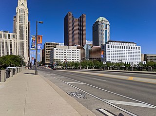
Columbus is the state capital and the most populous city in the U.S. state of Ohio. With a population of 905,748 for the 2020 census, it is the 14th-most populous city in the U.S., the second-most populous city in the Midwest after Chicago, and the third-most populous state capital. Columbus is the county seat of Franklin County; it also extends into Delaware and Fairfield counties. It is the core city of the Columbus, OH Metropolitan Statistical Area, which encompasses ten counties. The metropolitan area has a 2020 population of 2,138,926, making it the largest entirely in Ohio.
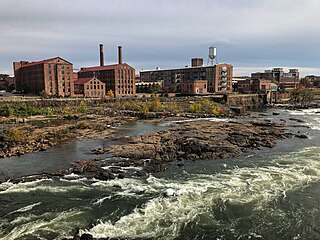
Columbus is a consolidated city-county located on the west-central border of the U.S. state of Georgia. Columbus lies on the Chattahoochee River directly across from Phenix City, Alabama. It is the county seat of Muscogee County, with which it officially merged in 1970. Columbus is the second-largest city in Georgia, and fields the state's fourth-largest metropolitan area. According to the 2020 United States census, Columbus has a population of 206,922 residents, with 328,883 in the Columbus metropolitan area. The metro area joins the nearby Alabama cities of Auburn and Opelika to form the Columbus–Auburn–Opelika Combined Statistical Area, which has an estimated population of 486,645 in 2019, according to the U.S. Census Bureau.

Columbus is a city in and the county seat of Platte County, in the state of Nebraska in the Midwestern United States. The population was 22,111 at the 2010 census. It is the 10th largest city in Nebraska, with 24,028 people as of the 2020 census.

Whitehall is a city in the U.S state of Ohio, located 6.6 miles (10.6 km) east of the state capital of Columbus in Franklin County. Whitehall had an estimated population of 18,062 in the 2010 census. Founded in 1947, Whitehall is a growing suburb of Columbus. Per the U.S. Census Bureau, Whitehall’s population is culturally and racially diverse, with over 50% of the population identifying as black, African American, Hispanic or Latino, with over 20% speaking a language other than English at home.

Columbus is a city in and the county seat of Colorado County in southeastern Texas and part of the Texas-German belt. The population was 3,655 as of the 2010 census. It is located on the Colorado River. The Colorado County Courthouse is listed on the National Register of Historic Places.
A regional park is an area of land preserved on account of its natural beauty, historic interest, recreational use or other reason, and under the administration of a form of local government.

Columbus Circle is a traffic circle and heavily trafficked intersection in the New York City borough of Manhattan, located at the intersection of Eighth Avenue, Broadway, Central Park South, and Central Park West, at the southwest corner of Central Park. The circle is the point from which official highway distances from New York City are measured, as well as the center of the 25 miles (40 km) restricted-travel area for C-2 visa holders.

Roxbury Crossing is a rapid transit station in Boston, Massachusetts. It serves the MBTA Orange Line, and is located on Tremont Street in the Mission Hill neighborhood. The current station opened in 1987 as part of the renovation and relocation of the southern Orange Line. Like all stations on the Orange Line, Roxbury Crossing is accessible.
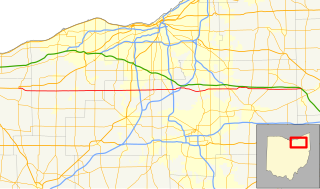
State Route 303 (SR 303) is a 75.71-mile-long (121.84 km) Ohio State Route that runs between Wakeman and Windham in the US state of Ohio. The highway is not listed on the National Highway System. Most of the route is a rural two-lane highway and passes through farmland, woodland, and residential properties. The route passes through the Cuyahoga Valley National Park. For some of its path, SR 303 runs generally parallel to the south of the Ohio Turnpike. SR 303 was first signed in 1932 on a section of the same alignment as today. The highway was extended towards the west in 1935. The highway was extended again in 1937. The eastern terminus was rerouted to its current intersection in the mid-1950s.
Georgian Heights is a neighborhood in West Columbus, in Columbus, Ohio, United States. It neighbors Holly Hill. The two are bounded together by Sullivant Avenue on the north, Clime Road on the south, Georgesville Road on the west, and Demorest Road on the east. There is a 10.7 acre public park, Georgian Heights Park, in the center of the area. Georgian Heights has a youth travel football team called the Georgian Heights Packers. The neighborhood is generally lower-middle class.
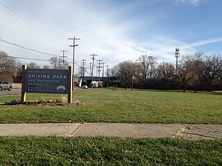
Driving Park is an urban residential area on the Near East Side of Columbus, Ohio just south of Interstate 70. Mainly a middle-class, predominantly African American neighborhood, Driving Park and its surrounding neighborhoods consist of an area of 17,730 residents. Driving Park received its name from its historic past as a large racing complex, first for horses and later for automobiles.

Peachtree Mall is a shopping mall in Columbus, Georgia. After the closing and demolition of Columbus Square Mall in the early 2000s, Peachtree Mall is the only enclosed shopping center in the city. Peachtree Mall is one of two major shopping areas in Columbus, the other being Columbus Park Crossing.
North Columbus, sometimes referred to as "Northside," is a district in Columbus, Georgia, situated just north of the district of Bibb City. It is bounded roughly by Moore Road on the north, Manchester Expressway to the south, Moon Road on the east, and J. R. Allen Parkway on the west.

Big Darby Creek is a scenic river located in northwestern central Ohio, and an important tributary to the Lower Scioto River. The river's major tributary is the Little Darby Creek.
The Metropolitan (METRA) Transit System is the primary provider of mass transportation in Muscogee County, Georgia, United States. The agency is the successor to the Columbus Transportation Company, a privately owned bus company founded in 1924 that had operated as the primary bus service in Columbus and Phenix City. In 1967, the city of Columbus purchased the Columbus Transportation Company and its assets after the company's bus services became unprofitable, with the city renaming the now public entity the Columbus Transportation System. In 1978, METRA assumed certain bus routes to nearby Fort Benning, which had been operated by Howard Bus Lines, a privately owned bus and cab company that ceased operations and filed for bankruptcy in 1978. Currently, ten routes serve the city, providing service Monday through Saturday.
Columbus Avenue (est.1860) in Boston, Massachusetts, runs from Park Square to just south of Melnea Cass Boulevard, as well as from Tremont Street to Walnut Avenue and Seaver Street, where it continues as Seaver Street to Blue Hill Avenue and to Erie Street, where it ends. The northern segment of Columbus Avenue carries MA-28 Northbound from Stuart Street to Melnea Cass Boulevard and MA-28 southbound from Clarendon Street to Melnea Cass Boulevard. The southern segment of Columbus Avenue carries MA-28 from Tremont Street to Walnut Avenue. Seaver Street carries MA-28 from Walnut Avenue to Blue Hill Avenue. It intersects the South End and Roxbury neighborhoods.
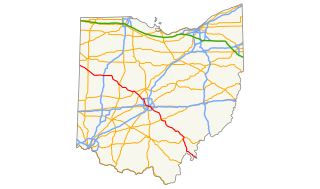
U.S. Route 33 (US 33) is a United States Numbered Highway running from near Elkhart, Indiana, to Richmond, Virginia. Within the state of Ohio, it is a predominantly southeast–northwest highway running from west of Willshire before crossing over into West Virginia via the Ravenswood Bridge over the Ohio River. The route runs through largely rural territory throughout most of the state's west-central, central, and southeastern regions, although it also passes through large portions of downtown Columbus.
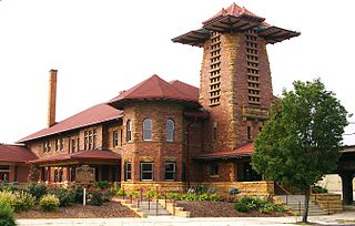
The Toledo and Ohio Central Railroad Station is a former railroad station located in Franklinton, by downtown Columbus, Ohio, known for its "whimsical and unusual" architecture. Built by the Toledo and Ohio Central Railroad in 1895, it served as a passenger station until 1930. It served as an office building for Volunteers of America from 1931 to 2003, and has served as a meeting hall for a firefighters' union since 2007. It was placed on the National Register of Historic Places in 1973.
Broad Street is a major thoroughfare in Central Ohio, predominantly in Franklin County and Columbus. It stretches east from West Jefferson at Little Darby Creek to Pataskala. The street is considered one of Columbus's two main roads, along with High Street.

