Related Research Articles

Molong is a small town in the Central West region of New South Wales, Australia, in Cabonne Shire.

Nyngan is a town in the centre of New South Wales, Australia, in the Bogan Shire local government area within the Orana Region of central New South Wales. At the 2016 census, Nyngan had a population of 1,988 people. Nyngan is situated on the Bogan River between Narromine and Bourke, on the junction of the Mitchell Highway and Barrier Highway, 656 km (408 mi) south of Charleville and 576 km (358 mi) north-west of Sydney by road. The Barrier Highway starts at Nyngan, and runs west to Cobar and on through Wilcannia and Broken Hill into South Australia.

Cooma is a town in the south of New South Wales, Australia. It is located 114 kilometres (71 mi) south of the national capital, Canberra, via the Monaro Highway. It is also on the Snowy Mountains Highway, connecting Bega with the Riverina.

Cunnamulla is a town and a locality in the Shire of Paroo, Queensland, Australia. It is 206 kilometres (128 mi) south of Charleville, and approximately 750 kilometres (470 mi) west of the state capital, Brisbane. In the 2021 census, Cunnamulla had a population of 1,233 people.
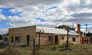
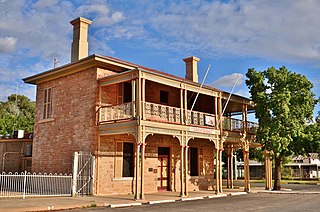
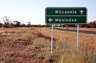
Menindee is a small town in the far west of New South Wales, Australia, in Central Darling Shire, on the banks of the Darling River, with a sign-posted population of 980 and a 2016 census population of 551. Menindee was the first town to be established on the Darling River. There are two distinct theories for the derivation of the township’s name: (a) from the Barkindji word "minandichi" for the shallow ephemeral lake north-west of the present-day township; (b) from the Barkindji word 'milhthaka', meaning "yolk of an egg".

Liverpool Plains Shire is a local government area located in the North West Slopes region of New South Wales, Australia. The Shire was formed on 17 March 2004 by the amalgamation of Quirindi Shire with parts of Parry, Murrurundi and Gunnedah shires.

Murrurundi( MURR-oo-RUN-dye), is a rural town located in the Upper Hunter Shire, in the Upper Hunter region of New South Wales, Australia.

Salmon Gums is a small town in Western Australia located 106 km north of Esperance on the Coolgardie-Esperance Highway. The name is derived from a prominent stretch of Eucalyptus salmonophloia trees which formed a landmark in the town's early days. The town is part of the Shire of Esperance. At the 2016 census, Salmon Gums had a population of 191.

Ivanhoe is a very small township on the Cobb Highway between the Lachlan and Darling rivers in New South Wales, Australia. It is located within the Central Darling Shire local government area. Ivanhoe functions as a service centre for the surrounding area. The township is characterised by a particularly wide main street. At the 2016 census, Ivanhoe had a population of 196 people.

Berrigan is a town on the Riverina Highway in the Riverina region of New South Wales, Australia. Berrigan is in the Berrigan Shire local government area and contains the Berrigan Shire Council offices. At the 2016 census, Berrigan had a population of 1,260.
Central Darling Shire is a local government area in the Far West region of New South Wales, Australia. The Shire is located adjacent to the Barrier Highway. Central Darling Shire was constituted in 1959 and at 53,511 square kilometres (20,661 sq mi), it is the largest incorporated local government area in New South Wales.

The South Coast refers to the narrow coastal belt from the Shoalhaven district in the north to the state border with Victoria in the south in the south-eastern part of the State of New South Wales, Australia. It is bordered to the west by the coastal escarpment of the Southern Tablelands, and is largely covered by a series of national parks, namely Jervis Bay National Park, Eurobodalla National Park, and Beowa National Park. To the east is the coastline of the Pacific Ocean, which is characterised by rolling farmlands, small towns and villages along a rocky coastline, interspersed by numerous beaches and lakes.

Pooncarie is a village in south-western New South Wales, Australia in Wentworth Shire. It is on the eastern side of the Darling River between Wentworth and Menindee. The surrounding region of Pooncarie is semi-arid with an outback landscape rich in eucalypt woodlands.
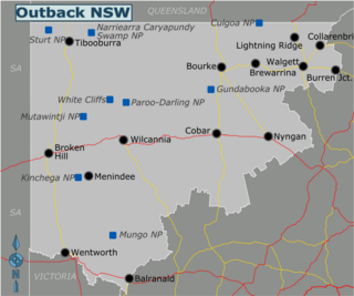
The Far West region of New South Wales, Australia refers generally to the western part of the state, which is too dry to support wheat or other crops or intensive pastoral endeavours. It is west of the North West Slopes, Central West and the Riverina. It is an area with limited rainfall, and the only major rivers found in it are the Darling River and the Murray River, which originate in the Great Dividing Range to the east. The region corresponds to the combination of the Australian Bureau of Meteorology's forecast areas of Upper Western and Lower Western. It also corresponds to the Western Division established under the New South Wales Western Lands Act 1901.
The North West Slopes region of New South Wales, Australia, refers generally to the area west of the Northern Tablelands, to the north of the Central West region and to the east of the Far West region. Despite its name, the region is in north-central New South Wales, corresponding generally to the Australian Bureau of Meteorology's forecast area of North West Slopes and Plains. The administrative areas of the region include the city of Tamworth, Gunnedah, Moree, Narrabri and Inverell.

Drought in Australia is defined by the Australian Bureau of Meteorology as rainfall over period greater than three-months being in the lowest decile of what has been recorded for that region in the past. This definition takes into account that drought is a relative term and rainfall deficiencies need to be compared to typical rainfall patterns including seasonal variations. Specifically, drought in Australia is defined in relation to a rainfall deficiency of pastoral leases and is determined by decile analysis applied to a certain area. Note that this definition uses rainfall only because long-term records are widely available across most of Australia. However, it does not take into account other variables that might be important for establishing surface water balance, such as evaporation and condensation.
Trida is a locality in Central Darling Shire in the Far West region of New South Wales, Australia.

The geography of Queensland in the north-east of Australia, is varied. It includes tropical islands, sandy beaches, flat river plains that flood after monsoon rains, tracts of rough, elevated terrain, dry deserts, rich agricultural belts and densely populated urban areas.
Matheson, New South Walesis civil parish of Manara County and a rural locality of Central Darling Shire in far western New South Wales.

Yelty, New South Wales is a civil parish of Manara County and a rural locality of Central Darling Shire in far western New South Wales.
References
- ↑ Conoble Railway Station.
- ↑ "Hot Dry Zone (with cooler winter)". Bureau of Meteorology. Archived from the original on 3 February 2007. Retrieved 2007-01-29.
- ↑ Conoble Railway Station.
- ↑ Conoble Lake, Bonzle.com.
- ↑ Conoble Station.
- ↑ Conoble Lake, exploreoz.com.