Conotton Creek | |
One Leg Creek | |
River | |
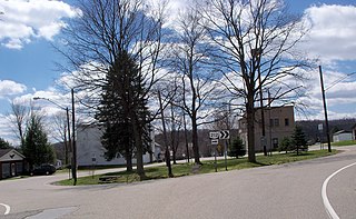
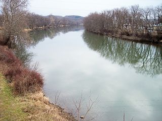
Connoton Creek flows under Ohio State Route 39 in Sherrodsville, Ohio | |
Country | United States |
---|---|
State | Ohio |
Source | |
- location | Green Township, Harrison County |
- elevation | 1,240 ft (378 m) [1] |
- coordinates | 40°19′42″N80°57′08″W / 40.32833°N 80.95222°W [2] |
Mouth | Tuscarawas River |
- location | Fairfield Township, Tuscarawas County |
- elevation | 874 ft (266 m) [1] |
- coordinates | 40°34′34″N81°23′32″W / 40.57611°N 81.39222°W Coordinates: 40°34′34″N81°23′32″W / 40.57611°N 81.39222°W [2] |
Length | 38.7 mi (62.3 km) [1] |
Basin | 286 sq mi (741 km2) [1] |
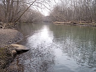
Conotton Creek ( /kɒˈnɒtən/ kon-OT-ən) is a tributary of the Tuscarawas River, 38.7 miles (62.3 km) long, in eastern Ohio in the United States. Via the Tuscarawas, Muskingum and Ohio Rivers, it is part of the watershed of the Mississippi River, draining an area of 286 square miles (741 km²) in Carroll, Harrison and Tuscarawas County, Ohio. The source is at 1240 feet and the mouth is at 874 feet. [1] Dover Dam, downstream on the Tuscarawas river, is normally dry, but can impound a reservoir on Conotton and tributaries to a pool elevation of 916 feet for downstream flood control by the Corp of Engineers. From its source in eastern Harrison County, Ohio the creek flows west northwest through Jewitt, Scio, Conotton, Bowerston, Leesville, Sherrodsville, New Cumberland and Somerdale before reaching its mouth in central Tuscarawas County, Ohio. The Wheeling and Lake Erie Railway is situated in the valley. Ohio State Route 151 runs in the valley from near the source to Bowerston. Ohio State Route 212 run along the valley from Bowerston to the mouth. The Conotton Creek Trail runs from Bowerston to Jewett.
The Tuscarawas River is a principal tributary of the Muskingum River, 129.9 miles (209 km) long, in northeastern Ohio in the United States. Via the Muskingum and Ohio rivers, it is part of the watershed of the Mississippi River, draining an area of 2,590 square miles (6,700 km2) on glaciated and unglaciated portions of the Allegheny Plateau.
Ohio is a Midwestern state in the Great Lakes region of the United States. Of the fifty states, it is the 34th largest by area, the seventh most populous, and the tenth most densely populated. The state's capital and largest city is Columbus.
The United States of America (USA), commonly known as the United States or America, is a country composed of 50 states, a federal district, five major self-governing territories, and various possessions. At 3.8 million square miles, the United States is the world's third or fourth largest country by total area and is slightly smaller than the entire continent of Europe's 3.9 million square miles. With a population of over 327 million people, the U.S. is the third most populous country. The capital is Washington, D.C., and the largest city by population is New York City. Forty-eight states and the capital's federal district are contiguous in North America between Canada and Mexico. The State of Alaska is in the northwest corner of North America, bordered by Canada to the east and across the Bering Strait from Russia to the west. The State of Hawaii is an archipelago in the mid-Pacific Ocean. The U.S. territories are scattered about the Pacific Ocean and the Caribbean Sea, stretching across nine official time zones. The extremely diverse geography, climate, and wildlife of the United States make it one of the world's 17 megadiverse countries.
The stream was declared navigable by the Ohio legislature in 1808, but the act was repealed in 1816, probably to allow the construction of mill dams. [3]
According to the Geographic Names Information System, Conotton Creek has also been known historically as: [2]
The Geographic Names Information System (GNIS) is a database that contains name and locative information about more than two million physical and cultural features located throughout the United States of America and its territories. It is a type of gazetteer. GNIS was developed by the United States Geological Survey in cooperation with the United States Board on Geographic Names (BGN) to promote the standardization of feature names.
Conotton Creek was known in the 19th century as One Leg Creek, named for an Indian who lived near its mouth. [3] [4] [5]
Native Americans, also known as American Indians, Indigenous Americans and other terms, are the indigenous peoples of the United States, except Hawaii. There are over 500 federally recognized tribes within the US, about half of which are associated with Indian reservations. The term "American Indian" excludes Native Hawaiians and some Alaska Natives, while Native Americans are American Indians, plus Alaska Natives of all ethnicities. Native Hawaiians are not counted as Native Americans by the US Census, instead being included in the Census grouping of "Native Hawaiian and other Pacific Islander".
Tributary Name [1] | Flows Into [1] | Source Elevation feet [1] | Mouth Elevation feet [1] | Mouth Location [6] | Length miles [1] | Drainage Area sq. Miles [1] | notes |
---|---|---|---|---|---|---|---|
Huff Run | Conotton Creek | 1066 | 875 | 40°35′18″N81°22′35″W / 40.58833°N 81.37639°W | 9.9 | 13.9 | A, Mineral City, Morges, Lindentree |
Beggar Run | Conotton Creek | 980 | 879 | 40°33′39″N81°19′2″W / 40.56083°N 81.31722°W | 2.7 | 4.45 | A |
Dog Run | Conotton Creek | 1029 | 880 | 40°32′30″N81°18′25″W / 40.54167°N 81.30694°W | 3.5 | 2.94 | A |
Indian Fork | Conotton Creek | 1116 | 887 | 40°31′18″N81°17′40″W / 40.52167°N 81.29444°W | 18.9 | 70.3 | A B Dellroy |
Elliott Run | Indian Fork | 1040 | 916 | 40°33′58″N81°12′38″W / 40.56611°N 81.21056°W | 3.5 | 4.63 | B |
Dellroy Creek | Indian Fork | 980 | 917 | 40°33′22″N81°12′3″W / 40.55611°N 81.20083°W | 1.5 | 1.3 | B |
Willow Run | Indian Fork | 1040 | 919 | 40°33′59″N81°11′48″W / 40.56639°N 81.19667°W | 4.8 | 8.99 | B, a.k.a. Messer Run |
Pleasant Valley Run | Indian Fork | 1080 | 936 | 40°33′18″N81°9′17″W / 40.55500°N 81.15472°W | 4.4 | 8 | B, New Harrisburg |
Cold Spring Run | Indian Fork | 1146 | 953 | 40°33′59″N81°7′43″W / 40.56639°N 81.12861°W | 3.4 | 6.39 | |
Town Creek | Indian Fork | 1120 | 974 | 40°33′52″N81°4′58″W / 40.56444°N 81.08278°W | 2.6 | 3.85 | Carrollton |
Gant Creek | Indian Fork | 1116 | 974 | 40°33′26″N81°5′37″W / 40.55722°N 81.09361°W | 4.6 | 8.33 | |
Thompson Run | Conotton Creek | 1060 | 903 | 40°30′07″N81°14′58″W / 40.50194°N 81.24944°W | 3.5 | 4.11 | A |
Holmes Run | Conotton Creek | 1000 | 917 | 40°28′52″N81°13′29″W / 40.48111°N 81.22472°W | 2.2 | 2.65 | Leavittsville |
McGuire Creek | Conotton Creek | 1230 | 920 | 40°28′30″N81°13′3″W / 40.47500°N 81.21750°W | 11.8 | 49.6 | C |
North Fork McGuire Creek | McGuire Creek | 1218 | 927 | 40°28′20″N81°11′35″W / 40.47222°N 81.19306°W | 12.6 | 26.6 | C Petersburg |
Bear Hole Run | North Fork McGuire Creek | 1071 | 948 | 40°30′44″N81°8′52″W / 40.51222°N 81.14778°W | 2.4 | 2.83 | C |
Scott Run | Conotton Creek | 1200 | 947 | 40°24′59″N81°8′39″W / 40.41639°N 81.14417°W | 4.7 | 3.23 | |
Dining Fork | Conotton Creek | 1270 | 974 | 40°24′25″N81°6′12″W / 40.40694°N 81.10333°W | 8 | 14.7 | Kilgore |
Kirby Run | Dining Fork | 1235 | 974 | 40°25′23″N81°4′57″W / 40.42306°N 81.08250°W | 3.3 | 3.47 | |
Irish Creek | Conotton Creek | 1240 | 967 | 40°23′37″N81°4′52″W / 40.39361°N 81.08111°W | 7.6 | 18.8 | a.k.a. Alder Creek, Snow Creek |
Lick Fork | Irish Creek | 1237 | 998 | 40°24′40″N81°2′7″W / 40.41111°N 81.03528°W | 4 | 5.05 | New Rumley |
Snow Creek | Irish Creek | 1240 | 1035 | 40°23′37″N81°4′52″W / 40.39361°N 81.08111°W | 3.4 | 4.72 | |
Jefferson Creek | Conotton Creek | 1270 | 1116 | 40°22′2″N80°59′46″W / 40.36722°N 80.99611°W | 4.6 | 6.56 | Germano |
Dover Dam 40°33′26″N81°24′44″W / 40.55722°N 81.41222°W , [7] on Tuscarawas River is normally dry, but can inundate this waterway to a pool elevation of 916 feet for downstream flood control by the corps of engineers. [8]
Atwood Dam 40°31′36″N81°17′5″W / 40.52667°N 81.28472°W , [9] near the mouth of Indian Fork, impounds Atwood Lake to a normal pool elevation of 928 feet and a maximum elevation of 941 feet on this waterway. [8]
Atwood Lake is a reservoir located in Tuscarawas and Carroll counties in east central Ohio. The lake is formed by Atwood Dam 40°31′36″N81°17′5″W across Indian Fork, a tributary of Conotton Creek. The lake is named for the community of Atwood 40°31′36″N81°17′5″W which was purchased, demolished and inundated. Evidence of an old rail station and roadbed can also be seen near Dellroy when the lake level is drawn down for winter. In addition to the Indian Fork the lake also has coves to the north up Elliott Run, Willow Run and two unnamed streams along Bark Road and Ohio State Route 542. The dam was completed in September 1936 at a cost of $1,403,900 by the Muskingum Watershed Conservancy District. The operation of the lake and dam, along with the property immediately surrounding the dam site, was transferred to the U.S. Army Corps of Engineers, Huntington District, after the approval of the Flood Control Act of 1939 by Congress. The MWCD continues to be responsible for the management of much of the reservoir areas behind the dam, serving as a partner to the U.S. Army Corps of Engineers for flood reduction. In addition to operating a number of recreation facilities, the MWCD cooperates with the Ohio Division of Wildlife for fishing and hunting management.
Leesville Dam 40°28′6″N81°11′41″W / 40.46833°N 81.19472°W [10] sits on McGuire Creek and impounds Leesville Lake to a normal pool elevation of 963 feet and a maximum elevation of 977.5 feet on this waterway. [8]
Leesville is a village in Carroll County, Ohio, United States. The population was 154 at the 2016 census. It is part of the Canton–Massillon Metropolitan Statistical Area.
Dover is a city in Tuscarawas County, Ohio, United States approximately 3 mi (4 km) northwest of New Philadelphia. The population was 12,210 at the 2000 census.
Wills Creek is a tributary of the Muskingum River, 92.2 mi (148.4 km) long, in eastern Ohio in the United States. Via the Muskingum and Ohio Rivers, it is part of the watershed of the Mississippi River. It drains an area of 853 mi² (2,209 km²).
The Sandy and Beaver Canal ran 73 miles (117 km) from the Ohio and Erie Canal at Bolivar, Ohio, to the Ohio River at Glasgow, Pennsylvania. It had 90 locks, was chartered in 1828 and completed in 1848. However, the middle section of the canal had many problems from the beginning and fell into disrepair. The canal ceased to operate in 1852, when the Cold Run Reservoir Dam outside of Lisbon, Ohio, broke, ruining a large portion of the canal.
The Sugden Reservoir is a Massachusetts reservoir located in Spencer, Massachusetts. It forms the headwaters of Shaw Brook, which is a tributary to Turkey Hill Creek, a major tributary to the Seven Mile River. This water body is part of the Chicopee River Watershed.
Sandy Creek is a tributary of the Tuscarawas River, 41.3 miles (66.5 km) long, in northeastern Ohio in the United States. Via the Tuscarawas, Muskingum and Ohio Rivers, it is part of the watershed of the Mississippi River, draining an area of 503 square miles (1,303 km²).
Sugar Creek is a tributary of the Tuscarawas River in northeastern Ohio in the United States. It is 45 miles (72 km) long. Via the Tuscarawas, Muskingum, and Ohio Rivers, it is part of the watershed of the Mississippi River, draining an area of 356 square miles (922 km²) on glaciated and unglaciated portions of the Allegheny Plateau.
Huff Run is a 9.9 mile (15.9 km) long tributary of the Conotton Creek in eastern Ohio within Sandy Township and Rose Township. Conotton Creek is a tributary of the Ohio River via the Tuscarawas River and the Muskingum River. Mineral City is the only incorporated town within the Huff Run Watershed.
The Alum Creek Lake reservoir was built in 1974, covers 5 sq mi (13 km2) and has a maximum capacity of 134,815 acre feet (166,292,000 m3).
The North Fork Feather River is a watercourse of the northern Sierra Nevada in the U.S. state of California. It flows generally southwards from its headwaters near Lassen Peak to Lake Oroville, a reservoir formed by Oroville Dam in the foothills of the Sierra, where it runs into the Feather River. The river drains about 2,100 square miles (5,400 km2) of the western slope of the Sierras. By discharge, it is the largest tributary of the Feather.
Paint Creek runs through Jones, Haskell, and Throckmorton counties, and is the main tributary of the Clear Fork Brazos River.
Leesville Lake is a reservoir located near Ohio State Route 212 and Leesville, Ohio. The lake is formed by Leesville Dam 40°28′6″N81°11′41″W across McGuire Creek, a tributary of Conotton Creek. The lake is named for the village of Leesville.
State Route 212 is a two-lane east–west state highway that runs within Stark, Tuscarawas, Carroll, and Harrison Counties in eastern Ohio. The western terminus of SR 212 is at U.S. Route 250 near Beach City, and its eastern terminus is at SR 151 in Bowerston. The route passes through rural areas but passes through small villages including Beach City, Bolivar, Zoar, Sherrodsville, and Leesville. It largely follows the valleys formed by the Tuscarawas River and Conotton Creek.
Dutch Hollow Lake is a man-made reservoir located in the Town of La Valle,, Wisconsin, United States. Created by developers in the 1970s by impounding the water of Dutch Hollow Creek, it is now a public-access lake regulated by the Wisconsin Department of Natural Resources with two public-access ramps. The 40-foot depth of the lake is maintained both by the flow from Dutch Hollow Creek and the pumping of groundwater.
Conotton is an unincorporated community in North Township, Harrison County, Ohio, United States. The community is serviced by the Bowerston post office, ZIP code 44695. It is located near Conotton Creek, State Route 151 and the Wheeling and Lake Erie Railway. According to the GNIS the community has also been known as Masterville.
Yatesville Dam is a dam in Lawrence County, Kentucky in the far eastern part of the state, close to the town of Louisa.
The South Fork McKenzie River is a tributary, about 31 miles (50 km) long, of the McKenzie River in the U.S. state of Oregon. It begins at about 4,500 feet (1,400 m) above sea level near Mink Lake in the Three Sisters Wilderness of the Cascade Range. Flowing northwest within Lane County, it meets the McKenzie River about 60 miles (97 km) from the larger river's confluence with the Willamette River.
The Cushaw Hydroelectric Project is a 7.5 megawatt (MW) dam and power house facility owned and operated by Virginia Electric Power Company, operating as Dominion Virginia Power.