Green Township, Harrison County, Ohio

Last updated

Green Township, Harrison County, Ohio
Oilfield infrastructure south of Hopedale, Ohio.JPG
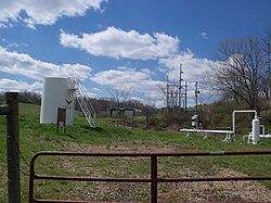
Utica Shale oil and gas is extracted in Green Township.
Map of Harrison County Ohio Highlighting Green Township.png
Location of Green Township in Harrison County
Coordinates: 40°19′23″N80°55′24″W / 40.32306°N 80.92333°W / 40.32306; -80.92333
Country United States
State Ohio
County Harrison
Area
  Total
35.62 sq mi (92.26 km2)
  Land35.14 sq mi (91.02 km2)
  Water0.48 sq mi (1.24 km2)
Elevation
[1]
1,198 ft (365 m)
Population
 (2020) [2]
  Total
1,719
  Density48.91/sq mi (18.89/km2)
Time zone UTC-5 (Eastern (EST))
  Summer (DST) UTC-4 (EDT)
FIPS code 39-31766 [3]
GNIS feature ID1086277 [1]

Green Township is one of the fifteen townships of Harrison County, Ohio, United States. As of the 2020 census the population was 1,719.

Contents

Geography

Located in the eastern part of the county, it borders the following townships:

The village of Hopedale is located in northeastern Green Township, and the unincorporated community of Pittsburgh Junction lies in the western part of the township.

Name and history

It is one of sixteen Green Townships statewide. [4]

Government

The township is governed by a three-member board of trustees, who are elected in November of odd-numbered years to a four-year term beginning on the following January 1. Two are elected in the year after the presidential election and one is elected in the year before it. There is also an elected township fiscal officer, [5] who serves a four-year term beginning on April 1 of the year after the election, which is held in November of the year before the presidential election. Vacancies in the fiscal officership or on the board of trustees are filled by the remaining trustees.

References

  1. 1 2 "US Board on Geographic Names". United States Geological Survey. October 25, 2007. Retrieved January 31, 2008.
  2. "Green township, Harrison County, Ohio - Census Bureau Profile". United States Census Bureau. Retrieved July 10, 2023.
  3. "U.S. Census website". United States Census Bureau . Retrieved January 31, 2008.
  4. "Detailed map of Ohio" (PDF). United States Census Bureau. 2000. Retrieved February 16, 2007.
  5. §503.24, §505.01, and §507.01 of the Ohio Revised Code. Accessed 4/30/2009.