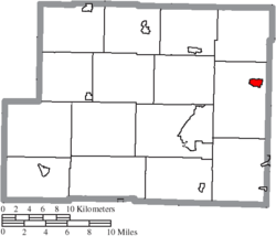
Hopedale, Ohio | |
---|---|
Coordinates: 40°19′35″N80°53′44″W / 40.32639°N 80.89556°W | |
Country | United States |
State | Ohio |
County | Harrison |
Incorporated | April 1, 1860 [1] |
Government | |
• Mayor | Michael Pelegreen, Sr. [2] |
Area | |
• Total | 1.17 sq mi (3.04 km2) |
• Land | 1.17 sq mi (3.04 km2) |
• Water | 0.00 sq mi (0.00 km2) |
Elevation | 1,240 ft (380 m) |
Population (2020) | |
• Total | 920 |
• Density | 784.98/sq mi (303.00/km2) |
Time zone | UTC-5 (Eastern (EST)) |
• Summer (DST) | UTC-4 (EDT) |
ZIP code | 43976 |
Area code | 740 |
FIPS code | 39-36260 [5] |
GNIS feature ID | 2398540 [4] |
Website | www |
Hopedale is a village in Harrison County, Ohio, United States. The population was 920 at the 2020 census.
Hopedale was platted in 1849. [6] A post office has been in operation at Hopedale since 1850. [7]
According to the United States Census Bureau, the village has a total area of 1.12 square miles (2.90 km2), all land. [8]
Census | Pop. | Note | %± |
---|---|---|---|
1870 | 359 | — | |
1880 | 414 | 15.3% | |
1890 | 424 | 2.4% | |
1900 | 365 | −13.9% | |
1910 | 391 | 7.1% | |
1920 | 561 | 43.5% | |
1930 | 742 | 32.3% | |
1940 | 901 | 21.4% | |
1950 | 888 | −1.4% | |
1960 | 932 | 5.0% | |
1970 | 916 | −1.7% | |
1980 | 857 | −6.4% | |
1990 | 685 | −20.1% | |
2000 | 984 | 43.6% | |
2010 | 950 | −3.5% | |
2020 | 920 | −3.2% | |
U.S. Decennial Census [9] |
As of the census [10] of 2010, there were 950 people, 369 households, and 249 families living in the village. The population density was 848.2 inhabitants per square mile (327.5/km2). There were 401 housing units at an average density of 358.0 per square mile (138.2/km2). The racial makeup of the village was 97.1% White, 0.8% African American, 0.3% Native American, 0.3% Asian, and 1.5% from two or more races. Hispanic or Latino of any race were 0.5% of the population.
There were 369 households, of which 29.0% had children under the age of 18 living with them, 53.1% were married couples living together, 8.4% had a female householder with no husband present, 6.0% had a male householder with no wife present, and 32.5% were non-families. 29.5% of all households were made up of individuals, and 16% had someone living alone who was 65 years of age or older. The average household size was 2.35 and the average family size was 2.88.
The median age in the village was 48 years. 21.6% of residents were under the age of 18; 4.8% were between the ages of 18 and 24; 20.1% were from 25 to 44; 28.3% were from 45 to 64; and 25.3% were 65 years of age or older. The gender makeup of the village was 48.9% male and 51.1% female.
As of the census [5] of 2000, there were 984 people, 383 households, and 278 families living in the village. The population density was 1,374.8 inhabitants per square mile (530.8/km2). There were 400 housing units at an average density of 558.8 per square mile (215.8/km2). The racial makeup of the village was 98.98% White, 0.61% African American, 0.10% Native American, and 0.30% from two or more races. Hispanic or Latino of any race were 0.51% of the population.
There were 383 households, out of which 28.2% had children under the age of 18 living with them, 62.1% were married couples living together, 8.6% had a female householder with no husband present, and 27.4% were non-families. 23.2% of all households were made up of individuals, and 14.6% had someone living alone who was 65 years of age or older. The average household size was 2.42 and the average family size was 2.83.
In the village, the population was spread out, with 21.3% under the age of 18, 4.7% from 18 to 24, 27.3% from 25 to 44, 22.4% from 45 to 64, and 24.3% who were 65 years of age or older. The median age was 43 years. For every 100 females there were 94.5 males. For every 100 females age 18 and over, there were 84.3 males.
The median income for a household in the village was $34,135, and the median income for a family was $38,558. Males had a median income of $35,263 versus $21,964 for females. The per capita income for the village was $16,536. About 9.8% of families and 11.8% of the population were below the poverty line, including 14.7% of those under age 18 and 8.5% of those age 65 or over.
Hopedale is a village in Tazewell County, Illinois, United States. The population was 865 at the 2010 census. It is part of the Peoria, Illinois Metropolitan Statistical Area. The town is also home to a small number of restaurants, general stores, parks, and the Hopedale Medical Complex.
Warsaw is a village in Coshocton County, Ohio, United States, along the Walhonding River. The population was 624 at the 2020 census.
Gordon is a village in Darke County, Ohio, United States. The population was 245 at the 2020 census.
Ithaca is a village in Darke County, Ohio, United States. The population was 81 at the 2020 census.
Addyston is a village in Miami Township, Hamilton County, Ohio, United States. Located along the Ohio River, it is a western suburb of the neighboring city of Cincinnati. The population was 927 at the 2020 census.
Cleves is a village in Miami Township, Hamilton County, Ohio, United States. Located along the Ohio River, it is a western suburb of Cincinnati. The population was 3,414 at the 2020 census.
Mowrystown is a village in Highland County, Ohio, United States. The population was 385 at the 2020 census.
Brinkhaven, once known as Mount Holly and Gann, is a village in Knox County, Ohio, United States. The population was 114 at the 2020 census.
Hanover is a village in Licking County, Ohio, United States. The population was 1,270 at the 2020 census. The village lies along Ohio State Route 16.
Hebron is a village in Licking County, Ohio, United States. The population was 2,326 at the 2020 census.
Miltonsburg is a village in Monroe County, Ohio, United States. The population was 42 at the 2020 census. Miltonsburg was named after Milton Pierson, son of Ohio pioneer David Pierson. David Pierson named Clarington, Ohio after his daughter Clarinda.
Shawnee is a village in Perry County, Ohio, United States. The population was 505 at the 2020 census. It is 9 miles (14 km) south of the county seat of New Lexington.
Tarlton is a village in Fairfield and Pickaway counties in the U.S. state of Ohio. The population was 254 at the 2020 census.
Limaville is a census-designated place (CDP) and former village in Stark County, Ohio, United States. The population was 151 at the 2020 census. It is part of the Canton–Massillon Metropolitan Statistical Area.
Elgin is a village in Van Wert County, Ohio, United States. The population was 49 at the 2020 census. It is included within the Van Wert, Ohio Micropolitan Statistical Area.
Macksburg is a village in Washington County, Ohio, United States, along the West Fork of Duck Creek. The population was 120 at the 2020 census. The village is about 28 miles (45 km) south of Cambridge, Ohio.
Wilson is a village in Belmont and Monroe counties in the U.S. state of Ohio. The population was 129 at the 2020 census. It is part of the Wheeling metropolitan area.
Gratiot is a village in Licking and Muskingum counties in the U.S. state of Ohio. The population was 215 at the 2020 census.
Verona is a village in Montgomery and Preble counties in the U.S. state of Ohio. The population was 403 at the 2020 census. It is part of the Dayton Metropolitan Statistical Area.
Hopedale is a town in Worcester County, Massachusetts, United States. It is located 25 miles southwest of Boston, in eastern Massachusetts. With origins as a Christian utopian community, the town was later home to Draper Corporation, a large loom manufacturer throughout the 20th century until its closure in 1980. Today, Hopedale has become a bedroom community for professionals working in Greater Boston and is home to highly ranked public schools. The population was 6,017 as of the 2020 census.