The Roman conquest of Britain refers to the conquest of the island of Britain by occupying Roman forces. It began in earnest in AD 43 under Emperor Claudius, and was largely completed in the southern half of Britain by 87 when the Stanegate was established. Conquest of the far north and Scotland took longer with fluctuating success.

Dacia was the land inhabited by the Dacians. The Greeks referred to them as the Getae and the Romans called them Daci.

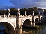
The Battle of the Milvian Bridge took place between the Roman Emperors Constantine I and Maxentius on 28 October 312. It takes its name from the Milvian Bridge, an important route over the Tiber. Constantine won the battle and started on the path that led him to end the Tetrarchy and become the sole ruler of the Roman Empire. Maxentius drowned in the Tiber during the battle; his body was later taken from the river and decapitated, and his head was paraded through the streets of Rome on the day following the battle before being taken to Africa.

Bithynia was an ancient region, kingdom and Roman province in the northwest of Asia Minor, adjoining the Sea of Marmara, the Bosporus, and the Black Sea. It bordered Mysia to the southwest, Paphlagonia to the northeast along the Pontic coast, and Phrygia to the southeast towards the interior of Asia Minor.
Mysia was a region in the northwest of ancient Asia Minor. It was located on the south coast of the Sea of Marmara. It was bounded by Bithynia on the east, Phrygia on the southeast, Lydia on the south, Aeolis on the southwest, Troad on the west, and the Propontis on the north. In ancient times it was inhabited by the Mysians, Phrygians, Aeolian Greeks and other groups.

The globus cruciger, also known as "the orb and cross", is an orb surmounted by a cross. It has been a Christian symbol of authority since the Middle Ages, used on coins, in iconography, and with a sceptre as royal regalia.
Cius, later renamed Prusias on the Sea after king Prusias I of Bithynia, was an ancient Greek city bordering the Propontis, in Bithynia and in Mysia, and had a long history, being mentioned by Herodotus, Xenophon, Aristotle, Strabo and Apollonius Rhodius.

Martinian was Roman emperor from July to September 324. He was raised to the purple by the emperor Licinius, whom he had hitherto served as a senior bureaucrat, during Licinius's civil war against the emperor Constantine I. Constantine defeated both emperors and forced them to abdicate, and executed them after initially showing leniency.

Selge was an important city in ancient Pisidia and later in Pamphylia, on the southern slope of Mount Taurus, modern Antalya Province, Turkey, at the part where the river Eurymedon River forces its way through the mountains towards the south.

Frederick William Hasluck was an English antiquarian, historian, and archaeologist.

The Moesian Limes is the modern term given to a collection of Roman fortifications between the Black Sea shore and Pannonia, present-day Hungary, consisting primarily of forts along the Danube to protect the Roman provinces of Upper and Lower Moesia south of the river.

The White Bridge was a Roman bridge across the river Granicus in Mysia in the north west of modern-day Turkey. Presumably constructed in the 4th century AD, it belonged in Ottoman times to the important road to Gallipoli on the Dardanelles. The structure was praised by early European travellers for its fine construction and marble facing, but was plundered for building material during the 19th century.

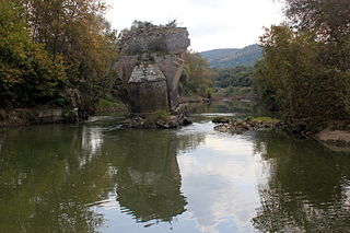
The Eurymedon Bridge was a late Roman bridge over the river Eurymedon, near Aspendos, in Pamphylia in southern Anatolia. The foundations and other stone blocks (spolia) of the Roman structure were used by the Seljuqs to build a replacement bridge in the 13th century, the Köprüpazar Köprüsü, which stands to this day. This bridge is characterized by a significant displacement along its mid-line, noticeable by looking at its ancient piers.

The Bridge near Seydikemer was a Roman segmental arch bridge near the ancient city of Xanthos in Lycia, in modern-day southwestern Turkey. Its remains are located on the upper reaches of the Xanthos river, 4 km upstream from the town of Seydikemer, at a site where the gravel river bed reaches a width of 500 m. Only a 29 m long and 4.5 m wide section on the right river bank, outside the inundation zone, is left today, having once served as approach to the bridge proper. Despite its near-complete destruction, the bridge represents a noteworthy example of the early use of segmental arches and hollow chambers in bridge building.

The Macestus Bridge or Bridge of Sultançayır was a Roman bridge across the Macestus River at Balıkesir, in the northwestern part of modern-day Turkey. Its flattened arches, slender piers and the hollow chamber system documented the progress made in late antique bridge building. A first cursory investigation of the 234 m long structure was conducted in the early 20th century, but since then its existence has been largely neglected by scholars. Current photos from 2009 show that the bridge has collapsed in the meantime.
Constantine's Bridge may refer to:

The Aesepus Bridge was a late antique Roman bridge over the Aesepus River in the ancient region of Mysia in modern-day Turkey. It is notable for its advanced hollow chamber system which has also been employed in other Roman bridges in the region, such as the Makestos Bridge. In a field examination carried out in the early 20th century, the four main vaults of the bridge were found in ruins, while nearly all piers and the seven minor arches had still remained intact. Today, the two remaining pier stubs in the riverbed are still extant, while the condition of the rest of the structure is difficult to determine.
The Aesepus River or Aisepos River was a river of Northern Mysia, mentioned by Homer in the Iliad as flowing past Zeleia, at the foot of Ida; and in another passage as one of the streams that flow from Ida. According to Strabo's interpretation of Homer, the Aesepus was the eastern boundary of Mysia. The Aesepus is the largest river of Mysia. According to Strabo, it rises in Mount Cotylus, one of the summits of Ida, and the distance between its source and its outlet is near 500 stadia. It is joined on the left bank by the Caresus, another stream which flows from Cotylus; and then taking a northeasterly and northerly course, it enters the Propontis, between the mouth of the Granicus River and the city of Cyzicus.
Gothograecia was a region in northwestern Asia Minor on the south side of the Sea of Marmara from at least the late 7th century until the mid-10th. It was part of the region of Opsikion in the Roman (Byzantine) Empire. Its inhabitants, the Greek-speaking descendants of a group of Goths, were known as Gothograeci.