
Ivory Coast is a sub-Saharan nation in southern West Africa located at 8 00°N, 5 00°W. The country is approximately square in shape. Its southern border is a 515 km (320 mi) coastline on the Gulf of Guinea on the north Atlantic Ocean. On the other three sides it borders five other African nations for a total of 3,458 km (2,149 mi): Liberia to the southwest for 778 km (483 mi), Guinea to the northwest for 816 km (507 mi), Mali to the north-northwest for 599 km (372 mi), Burkina Faso to the north-northeast for 545 km (339 mi), and Ghana to the east for 720 km (447 mi).

Russia is the largest country in the world, covering over 17,125,192 km2 (6,612,074 sq mi), and encompassing more than one-eighth of Earth's inhabited land area. Russia extends across eleven time zones, and has the most borders of any country in the world, with sixteen sovereign nations.

The geography of Switzerland features a mountainous and landlocked country located in Western and Central Europe. Switzerland's natural landscape is marked by its numerous lakes and mountains. It is surrounded by five countries: Austria and Liechtenstein to the east, France to the west, Italy to the south and Germany to the north. Switzerland has a maximum north–south length of 220 kilometres (140 mi) and an east–west length of about 350 kilometres (220 mi).

Austria is a predominantly mountainous country in Central Europe, approximately between Germany, Italy and Hungary. It has a total area of 83,871 square kilometres (32,383 sq mi).

The Alps form part of a Cenozoic orogenic belt of mountain chains, called the Alpide belt, that stretches through southern Europe and Asia from the Atlantic all the way to the Himalayas. This belt of mountain chains was formed during the Alpine orogeny. A gap in these mountain chains in central Europe separates the Alps from the Carpathians to the east. Orogeny took place continuously and tectonic subsidence has produced the gaps in between.
UNESCO Biosphere Reserves are environment-protected scientific-research institutions of international status that are created with the intent for conservation in a natural state the most typical natural complexes of biosphere, conducting background ecological monitoring, studying of the surrounding natural environment, its changes under the activity of anthropogenic factors.
Europe, the westernmost portion of Eurasia, is often divided into regions and subregions based on geographical, cultural or historical factors. Since there is no universal agreement on Europe's regional composition, the placement of individual countries may vary based on criteria being used. For instance, the Balkans is a distinct geographical region within Europe, but individual countries may alternatively be grouped into South-eastern Europe or Southern Europe.

Europe is traditionally defined as one of seven continents. Physiographically, it is the northwestern peninsula of the larger landmass known as Eurasia ; Asia occupies the centre and east of this continuous landmass. Europe's eastern frontier is usually delineated by the Ural Mountains in Russia, which is the largest country by land area in the continent. The southeast boundary with Asia is not universally defined, but the modern definition is generally the Ural River or, less commonly, the Emba River. The boundary continues to the Caspian Sea, the crest of the Caucasus Mountains, and on to the Black Sea. The Bosporus, the Sea of Marmara, and the Dardanelles conclude the Asian boundary. The Mediterranean Sea to the south separates Europe from Africa. The western boundary is the Atlantic Ocean. Iceland is usually included in Europe because it is over twice as close to mainland Europe as mainland North America. There is ongoing debate on where the geographical centre of Europe falls.
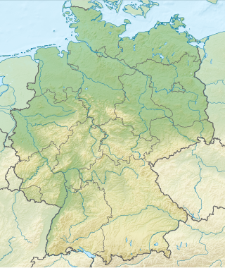
Germany is a country in Central and Western Europe that stretches from the Alps, across the North European Plain to the North Sea and the Baltic Sea. It is the second-most populous country in Europe after Russia, and is seventh-largest country by area in the continent. The area of Germany ranked 63rd and covers 357,021 km2 (137,847 sq mi), consisting of 349,223 km2 (134,836 sq mi) of land and 7,798 km2 (3,011 sq mi) of waters, smaller than Japan but larger than Republic of the Congo.
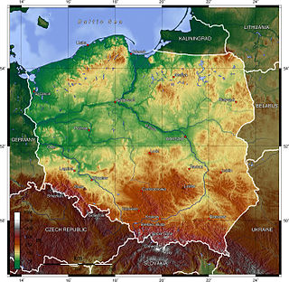
Poland is a country that extends across the North European Plain from the Sudetes and Carpathian Mountains in the south to the sandy beaches of the Baltic Sea in the north. Poland is the fifth-most populous country of the European Union and the ninth-largest country in Europe by area. The territory of Poland covers approximately 312,696 km2 (120,733 sq mi), of which 98.52% is land and 1.48% is water. The Polish coastline was estimated at 770 km (478 mi) in length. Poland's highest point is Rysy, at 2,500 m (8,202 ft).

The Central European mixed forests ecoregion is a temperate hardwood forest covering much of northeastern Europe, from Germany to Russia. The area is only about one-third forested, with pressure from human agriculture leaving the rest in a patchwork of traditional pasture, meadows, wetlands. The ecoregion is in the temperate broadleaf and mixed forest biome, and the Palearctic realm, with a Humid Continental climate. It covers 731,154 km2 (282,300 sq mi).

The Mediterranean Biogeographic Region is the biogeographic region around and including the Mediterranean Sea. The term is defined by the European Environment Agency as applying to the land areas of Europe that border on the Mediterranean Sea, and the corresponding territorial waters. The region is rich in biodiversity and has many endemic species. The term may also be used in the broader sense of all the lands of the Mediterranean Basin, or in the narrow sense of just the Mediterranean Sea.

The Boreal Biogeographic Region is the biogeographic region of Northern Europe that consists primarily of coniferous forests and wetlands.
The Atlantic Biogeographic Region is the biogeographic region of Europe bordering the Atlantic Ocean and North Sea.

The Black Sea Biogeographic Region is a biogeographic region of land bordering the west and south of the Black Sea, as defined by the European Environment Agency.

The Alpine Biogeographic Region is a biogeographic region, as defined by the European Environment Agency, that covers the mountainous regions of Europe.

The Pannonian Biogeographic Region is a biogeographic region, as defined by the European Environment Agency. It covers the lowlands of the Pannonian Basin centered on Hungary.

The Steppic Biogeographic Region is a biogeographic region of Europe, as defined by the European Environment Agency.

The Atlantic mixed forests is a terrestrial ecoregion in western Europe. It extends along the western edge of continental Europe, from southwestern France through northern France, Belgium, the Netherlands, northwestern Germany, and western Denmark. Most of the region's forests and dunes have been converted to fields, pastures, and forest plantations, and its once-extensive wetlands have mostly been drained and filled.

