
Dromineer is a small village and townland in County Tipperary, Ireland. It is situated on the shores of Lough Derg on the River Shannon. The village is located 10 km north of Nenagh on the R495 road. It is a civil parish in the historical barony of Ormond Lower. Historic documents describe the places as "Dromynnyre".
Union Hall, also Unionhall, is a small fishing village located in County Cork, Ireland, located on the west side of Glandore Harbour. Its nearest neighbour to the west is Castletownshend; to the east, Glandore village. It is approximately 10 kilometres south-east of Skibbereen. As of the 2016 census, 270 people were living in Union Hall.

Shanballymore is a small village in north County Cork, Ireland. It neighbours the towns of Doneraile, Kildorrery and Castletownroche, and is off the main route from Mallow to Mitchelstown. Shanballymore is part of the Cork East Dáil constituency.

Stranorlar is a town, townland and civil parish in the Finn Valley of County Donegal, in Ireland. Stranorlar and Ballybofey form the Twin Towns.

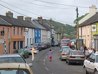
Cloughjordan, officially Cloghjordan, is a town in County Tipperary in Ireland. It is in the barony of Ormond Lower, and it is also a parish in the Roman Catholic Diocese of Killaloe.

Stradone is a village located in County Cavan, Ireland. It is situated in the civil parish of Laragh six miles from Cavan, near the N3 road between Cavan and Virginia. Stradone is classified as a 'small village' in the Cavan County Council Development Plan 2014-2020.

Cloughjordan railway station serves the town and surrounding area of Cloughjordan, County Tipperary in the Midwest of Ireland. The station is located 1 km south west of the town centre on the Templemore Road.
Moygownagh is a parish in the Barony of Tyrawley, County Mayo, Ireland. Moygownagh borders the parishes of Kilfian, and Crossmolina.

Binghamstown is a townland and village in County Mayo, Ireland. It lies on the R313 regional road on the Mullet Peninsula, near the town of Belmullet. The townland of Binghamstown has an area of approximately 3 square kilometres (1 sq mi), and had a population of 106 people as of the 2011 census. Binghamstown is in the electoral division of An Geata Mór Thuaidh.

Moneygall is a small village on the border of counties Offaly and Tipperary, in Ireland. It is situated on the R445 road between Dublin and Limerick. There were 313 people living in the village as of the 2016 census. Moneygall has a Catholic church, motorway service station, a car sales and repair centre, a national school, a Garda station and two pubs. The nearest Church of Ireland church, Borrisnafarney, is 2 km from the village beside the former Loughton Demesne.
Currow is a rural village in County Kerry in south west Ireland, located approximately 12 km from Killarney and 18 km from Tralee. Currow is situated on the Brown Flesk River, a tributary of the River Maine.

Farran is a village in County Cork, Ireland, in the parish of Ovens. It lies on the southside of the River Lee. Farran is 12 miles (19 km) west from Cork City on the N22 road.

Glenville is a village and townland in County Cork, Ireland. It is situated approximately 20 km northeast of Cork city. Glenville is part of the Cork North-Central.
Modreeny is a townland and a civil parish in the historical barony of Ormond Lower, County Tipperary in Ireland situated on the R490 road between the towns of Borrisokane and Cloughjordan. Ormond Foxhounds are based at kennels at Modreeny.
Kilruane is a townland and civil parish in the historical barony of Ormond Lower, County Tipperary in Ireland. It is located between Nenagh and Cloughjordan.
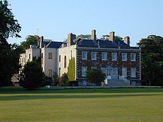
Cloughjordan House is a private residence in Cloughjordan, County Tipperary, Ireland. Built on the site of a tower house that was extended in the 17th and 18th centuries. The present house comprises a central two storey five bay section flanked by two gable fronted sections.
Newbridge Demesne is an early 18th-century Georgian estate and mansion situated in north County Dublin, Ireland. It was built in 1736 by Charles Cobbe, Archbishop of Dublin, and remained the property of his Cobbe descendants until 1985. It was then acquired by Dublin County Council, in a unique arrangement, under which Newbridge House would remain the family home.
Mullenkeagh is a townland in the Barony of Ormond Lower in County Tipperary, Ireland. It is located at the west end of Cloughjordan Main Street in the civil parish of Modreeny. The alternative spelling of Mulinkeagh is recognised.
Sopwell is a townland in the historical Barony of Ormond Lower, County Tipperary, Ireland.
Sharavogue is a townland in the historical Barony of Clonlisk, County Offaly, Ireland. It is a rural area located near the junction of the N52 road and the R492 between Roscrea and Birr. The Little Brosna River flows under Sharavogue bridge.
