Hydaburg is a first-class city in the Prince of Wales-Hyder Census Area, in the U.S. state of Alaska. The population was 382 at the 2000 census and 376 as of the 2010 census. The name "Hydaburg" refers to the Haida people.

Klawock is a city in Prince of Wales–Hyder Census Area, in the U.S. state of Alaska, on the west coast of Prince of Wales Island, on Klawock Inlet, across from Klawock Island. The population was 755 at the 2010 census, down from 854 in 2000. It is located 90 kilometres (56 mi) from Ketchikan, 11 kilometres (6.8 mi) from Craig, and 39 kilometres (24 mi) from Hollis.

The Alexander Archipelago is a 300-mile (480 km) long archipelago in North America lying off the southeastern coast of Alaska. It contains about 1,100 islands, the tops of submerged coastal mountains that rise steeply from the Pacific Ocean. Deep channels and fjords separate the islands and cut them off from the mainland. The islands shelter the northern part of the Inside Passage as it winds its way among them.

The Dixon Entrance is a strait about 80 kilometers (50 mi) long and wide in the Pacific Ocean at the Canada–United States border, between the U.S. state of Alaska and the province of British Columbia in Canada. The Dixon Entrance is part of the Inside Passage shipping route. It forms part of the maritime boundary between the U.S. and Canada, although the location of that boundary here is disputed.

Orca Inlet is an arm of Prince William Sound in southern Alaska. The town of Cordova was founded on its coast in 1906. All marine traffic reaches the town through Orca Inlet.

Dall Island is an island in the Alexander Archipelago off the southeast coast of Alaska, just west of Prince of Wales Island and north of Canadian waters. Its peak elevation is 2,443 feet above sea level. Its land area is 254.0 square miles (657.9 km2), making it the 28th largest island in the United States. Dall is used economically for fishing and limestone quarrying.
Long Island is an island in the Alexander Archipelago of southeastern Alaska, United States. It lies across the Kaigani Strait from the southern portion of Dall Island and west of the southern part of Prince of Wales Island. Directly to its north is Sukkwan Island. Long Island forms part of the western boundary of Cordova Bay, and has a land area of 116.136 km2 and was unpopulated at the 2000 census.

During the Age of Discovery, the Spanish Empire undertook several expeditions to the Pacific Northwest of North America. Spanish claims to the region date to the papal bull of 1493, and the Treaty of Tordesillas signed in 1494. In 1513, this claim was reinforced by Spanish explorer Vasco Núñez de Balboa, the first European to sight the Pacific Ocean, when he claimed all lands adjoining this ocean for the Spanish Crown. Spain only started to colonize the claimed territory north of present-day Mexico in the 18th century, when it settled the northern coast of Las Californias.

Wales Island is an island on the North Coast of British Columbia, Canada, situated east of the Dixon Entrance at the entrance to Portland Inlet.
Princess Royal was a British merchant ship that sailed on fur trading ventures in the late 1780s, and was captured at Nootka Sound by Esteban José Martínez of Spain during the Nootka Crisis of 1789. Called Princesa Real while under the Spanish Navy, the vessel was one of the important issues of negotiation during the first Nootka Convention and the difficulties in carrying out the agreements. The vessel also played an important role in both British and Spanish exploration of the Pacific Northwest and the Hawaiian Islands. In 1790, while under Spanish control, Princesa Real carried out the first detailed examination of the Strait of Juan de Fuca by non-indigenous peoples, finding, among other places, the San Juan Islands, Haro Strait, Esquimalt Harbour near present-day Victoria, British Columbia, and Admiralty Inlet.
The 1949 Queen Charlotte Islands earthquake struck Haida Gwaii and the Pacific Northwest coast at 8:01 p.m. PDT on August 21. The earthquake had a moment magnitude of 8.0 and a surface wave magnitude of 8.1. The maximum Mercalli Intensity in the event was VIII (Severe).
Sukkwan Island is an island in the Alexander Archipelago of southeastern Alaska, United States. It lies just off the southwest coast of Prince of Wales Island. To its west lies Dall Island, and to its south lies Long Island. The nearest city is Hydaburg, to its north on Prince of Wales Island, just across the Sukkwan Strait. The island's area is 166.9 km2 and a population of nine persons was reported at the 2000 census.
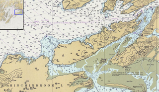
Orca Bay is a bay in Prince William Sound, Alaska.
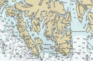
Hetta Inlet is a deep embayment in the southwestern coast of Prince of Wales Island in the U.S. state of Alaska. It connects with the Pacific Ocean through Cordova Bay. The head of the inlet is separated by a 200 feet (61 m) divide from the West Arm of Cholmondeley Sound. The shores are abrupt from the water's edge, and the channels and inlets are deep. The precipitation is probably a little greater than at Ketchikan, and the mean annual temperature is slightly higher. The white crystalline limestone of the Wales series, striking nearly north and south, is the predominant country rock of Hetta Inlet. In it are intruded many igneous rocks, some schistose, some massive. The white limestones are closely folded and have great variation in dip. The igneous rocks, so far as determined from the small collection made, include gabbros, diorites, amphibolites, diabases, and pyroxene-syenites. All these are comparatively massive. The greenstoneschists, which occupy considerable areas, are chloritic.

Sulzer, Alaska is a ghost town on Prince of Wales Island in the U.S. state of Alaska. The community centered on a copper mine established by William Sulzer on the shore of Hetta Inlet. Operated by the Alaska Consolidated Mining and Smelting Company, the Jumbo Mine was active from 1907 to 1918 and was one of Alaska's largest copper producers.
Moira Sound is a branching inlet on the east side of the southern end of Prince of Wales Island in U.S. state of Alaska. It is situated within the Tongass National Forest.

The Hydaburg Totem Park is a city park in the small community of Hydaburg, Alaska, located on the western side of Prince of Wales Island in southeastern Alaska. The park is also part of the many parks inside the Tongass National Forest. The park, created in 1939, contains a collection of preserved and recreated totem poles, based on originals collected from small communities abandoned by the Haida people to form Hydaburg. The old totem poles were brought to the park by crews from the Civilian Conservation Corps, and were recreated and preserved under the guidance of Haida master carvers. The park has been the subject of a major restoration effort in the 2010s. The old totem poles, that were removed from the park, remain in outdoor storage near the old cannery in the downtown area of the village.
Kaigani Strait is a waterway in the U.S. state of Alaska, the southern part of the strait between Long Island and Dall Island. The Alaska Native name, as reported by Etolin is 1833, is Kalgan.
American Bay is a waterway in the U.S. state of Alaska. It is located on the east side of Dall Island, facing Long Island across Kaigani Strait.


