
Witney is a market town on the River Windrush in West Oxfordshire in the county of Oxfordshire, England. It is 12 miles (19 km) west of Oxford. The place-name "Witney" is derived from the Old English for "Witta's island". The earliest known record of it is as Wyttannige in a Saxon charter of 969. The Domesday Book of 1086 records it as Witenie.
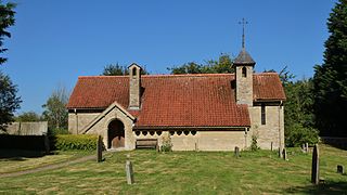
Curbridge is a village and civil parish immediately southwest of Witney, in the West Oxfordshire district, in the county of Oxfordshire, England. The 2011 Census recorded the parish's population as 529. Since 2012 it has been part of the Curbridge and Lew joint parish council area, sharing a parish council with the adjacent civil parish of Lew.

Ducklington is a village and civil parish on the River Windrush 1 mile (1.6 km) south of Witney in West Oxfordshire. The 2011 Census recorded the parish's population as 1,581.

Bampton, also called Bampton-in-the-Bush, is a settlement and civil parish in the Thames Valley about 4+1⁄2 miles (7 km) southwest of Witney in Oxfordshire. The parish includes the hamlet of Weald. The 2011 Census recorded the parish's population as 2,564. Bampton is variously referred to as both a town and a village. The Domesday Book recorded that it was a market town by 1086. It continued as such until the 1890s. It has both a town hall and a village hall.

Standlake is a village and civil parish in West Oxfordshire about 5 miles (8 km) southeast of Witney and 7 miles (11 km) west of Oxford, England. The parish includes the hamlet of Brighthampton. The 2011 Census recorded the parish's population as 1,497. The River Windrush flows past the village and with its tributary Medley Brook it forms much of the eastern boundary of the parish. The western boundary has been subject to changes and disputes in past centuries. It now follows Brighthampton Cut, an artificial land drain dug in the 19th century. The Windrush joins the River Thames at Newbridge just over 1 mile (1.6 km) to the south.

Cokethorpe School is an independent day school in Hardwick, West Oxfordshire. Founded in 1957 by Francis Brown, it is a member of HMC, IAPS, and The Society of Heads. The school has approximately 660 students aged 4 to 18.

Yelford is a hamlet in Hardwick-with-Yelford civil parish. It is about 3 miles (5 km) south of Witney.

Aston is a village about 4 miles (6.4 km) south of Witney in West Oxfordshire, England. The village is part of the civil parish of Aston, Cote, Shifford and Chimney. The southern boundary of the parish is the River Thames. The 2011 Census recorded the parish's population as 1,374.
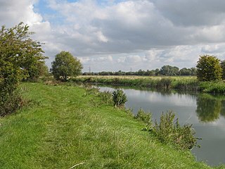
Chimney is a hamlet on the River Thames near Shifford Lock, 6 miles (9.7 km) south of Witney in Oxfordshire. It is part of the civil parish of Aston, Cote, Shifford and Chimney. Chimney Meadows 620 acres (250 ha) is the largest nature reserve managed by the Berkshire, Buckinghamshire and Oxfordshire Wildlife Trust.
Brighthampton is a hamlet about 4 miles (6.4 km) south of Witney in West Oxfordshire and contiguous with the village of Standlake.

Lew is a village and civil parish about 2+1⁄2 miles (4 km) southwest of Witney in the West Oxfordshire District of Oxfordshire, England. The 2001 Census recorded the parish population as 65. Since 2012 the parish has been part of the Curbridge and Lew joint parish council area, sharing a parish council with the adjacent civil parish of Curbridge.

Shifford is a hamlet in the civil parish of Aston, Cote, Shifford and Chimney in Oxfordshire, England. It is on the north bank of the River Thames about 6 miles (10 km) south of Witney.
Weald is a hamlet in Bampton civil parish in Oxfordshire, England. It lies about 0.7 miles (1.1 km) southwest of Bampton. The toponym Weald is from the Old English for "woodland". The place was recorded by name in the late 12th century when Osney Abbey acquired a house there. It was a separate township by the 13th century. In the 18th and 19th centuries the township included much of the southwest part of the town of Bampton itself. A large late 17th century manor house, Weald Manor, was remodelled at around 1730. It is a Grade II* listed building.
Clapton Crabb Rolfe was an English Gothic Revival architect whose practice was based in Oxford.
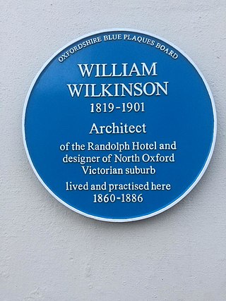
William Wilkinson (1819–1901) was a British Gothic Revival architect who practised in Oxford, England.
Hardwick-with-Yelford is a civil parish in West Oxfordshire. The parish includes the villages of Hardwick and Yelford. It was formed in 1932 from the parish of Yelford, most of the parish of Hardwick, and parts of the parishes of Ducklington and Standlake.
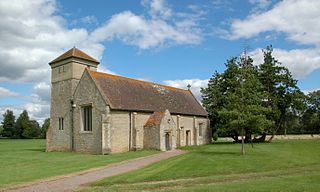
Hardwick is a village in the civil parish of Hardwick-with-Yelford in West Oxfordshire. The village is on the A415 road about 2.5 miles (4 km) southeast of Witney. It lies on the river Windrush. Hardwick was historically a hamlet or chapelry in the ancient parish of Ducklington. It became a separate civil parish in 1866. In 1932 the parish was merged with the parish of Yelford and large parts of the parishes of Ducklington and Standlake to form the civil parish of Hardwick-with-Yelford.
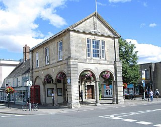
Witney Town Hall is a municipal structure in Spring Lane in Market Square, Witney, Oxfordshire, England. The town hall, which is the headquarters of Witney Town Council, is a Grade II* listed building.

Woodstock Town Hall is a municipal building in the Market Place in Woodstock, Oxfordshire, England. The building, which is used as a community events venue, is a Grade II listed building.

Bampton Town Hall is a municipal building in the Market Square in Bampton, Oxfordshire, England. The building, which is primarily used as an arts centre, is a Grade II listed building.


