Related Research Articles

Clontygrigny is a townland in the civil parish of Kildallan, barony of Tullyhunco, County Cavan, Ireland.

Cornacrum is a townland in the civil parish of Kildallan, barony of Tullyhunco, County Cavan, Ireland.
Cornahaia is a townland in the civil parish of Kildallan, barony of Tullyhunco, County Cavan, Ireland.
Derrinlester is a townland in the civil parish of Kildallan, barony of Tullyhunco, County Cavan, Ireland.
Drumlarah is a townland in the civil parish of Kildallan, barony of Tullyhunco, County Cavan, Ireland.
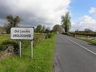
Ardlougher is a townland in the civil parish of Kildallan, barony of Tullyhunco, County Cavan, Ireland.

Dring is a small townland in the civil parish of Kildallan, barony of Tullyhunco, County Cavan, Ireland.
Clonkeen is a townland in the civil parish of Kildallan, barony of Tullyhunco, County Cavan, Ireland.

Aghnacreevy is a townland in the civil parish of Kildallan, barony of Tullyhunco, County Cavan, Ireland.

Mackan is a townland in the civil parish of Kildallan, barony of Tullyhunco, County Cavan, Ireland.
Drummany is a townland in the civil parish of Kildallan, electoral district of Diamond, barony of Tullyhunco, County Cavan, Ireland.
Laheen is a townland in the civil parish of Killashandra, barony of Tullyhunco, County Cavan, Ireland.
Claragh is a townland in the civil parish of Kildallan, barony of Tullyhunco, County Cavan, Ireland.
Drumcartagh is a townland in the civil parish of Kildallan, barony of Tullyhunco, County Cavan, Ireland. It is also called Diamondhill.
Clooneen is a townland in the civil parish of Kildallan, barony of Tullyhunco, County Cavan, Ireland.
Killygowan is a townland in the civil parish of Kildallan, barony of Tullyhunco, County Cavan, Ireland.
Makief is a townland in the civil parish of Kildallan, barony of Tullyhunco, County Cavan, Ireland. It is also called Hill or ‘The Hill’.
Drummully West is a townland in the civil parish of Kildallan, barony of Tullyhunco, County Cavan, Ireland.

Drumerdannan is a townland in the civil parish of Kildallan, barony of Tullyhunco, County Cavan, Ireland.

Drumbagh is a townland in the civil parish of Kildallan, barony of Tullyhunco, County Cavan, Ireland.
References
- ↑ "Placenames Database of Ireland - Cornahaia" . Retrieved 29 February 2012.
- ↑ "IreAtlas" . Retrieved 29 February 2012.
- ↑ "Inquisitionum in Officio Rotulorum Cancellariae Hiberniae Asservatarum Repertorium". command of his majesty King George IV. In pursuance of an address of the house of Commons of Great Britain (an Ireland). 1 October 2018 – via Google Books.
- ↑ Inquisitionum in Officio Rotulorum Cancellariae Hiberniae Asservatarum Repertorium. command of his majesty King George IV. In pursuance of an address of the house of Commons of Great Britain (an Ireland). 1829. pp. 5–6. Retrieved 20 August 2018.
- ↑ Peter Kenny (12 September 2005). "Leabharlann Náisiúnta na hÉireann" (PDF). Retrieved 20 August 2018.
- ↑ "List of the Several Baronies and Parishes, In the County of Cavan" (PDF). Cavan County Libraries. 1709. Archived from the original (PDF) on 6 April 2016. Retrieved 1 October 2018.
- ↑ "1821 Census - Townland of Cornasker" (PDF). National Archives of Ireland.
- ↑ "1821 Census - Townland of Cornasker" (PDF). National Archives of Ireland.
- ↑ "Griffith's Valuation". www.askaboutireland.ie.
- ↑ "National Archives: Census of Ireland 1901" . Retrieved 19 October 2016.
- ↑ "National Archives: Census of Ireland 1911" . Retrieved 19 October 2016.
