Stradone, County Cavan

Last updated

Stradone
Sraith an Domhain
Village
Entering Stradone on the R165 (Radharc Na Habhann) road (geograph 3069454).jpg
Entering Stradone on the R165 regional road
Ireland adm location map.svg
Red pog.svg
Stradone
Coordinates: 53°58′59″N7°14′13″W / 53.983°N 7.237°W / 53.983; -7.237
Country Ireland
County County Cavan
Barony Loughtee Upper
Civil parish Laragh (or Larah)

Stradone (Irish : Sraith an Domhain) [1] is a village located in County Cavan, Ireland. It is situated in the civil parish of Laragh (or Larah) [1] six miles from Cavan, near the N3 road between Cavan and Virginia. Stradone is classified as a 'small village' in the Cavan County Council Development Plan 2014-2020. [2]

Contents

Location

Stradone is a small village approximately 10 km (6 mi) directly east of Cavan. It is located just off the National Route N3, Dublin to Cavan, where the R165 regional road and L6046 local road converge. It is situated in the Stradone Local Electoral Area. [1]

Cavan County Council estimated a population of approximately 60 persons living within the development boundary of the village.[ citation needed ][ when? ]

History

Evidence of ancient settlement in the area includes a number of ringfort sites in the neighbouring townlands of Aghagolrick and Raheelagh. [3]

A large estate house in the area, Stradone House, was built between 1828 and 1835 by architect John Benjamin Keane for the landowning Burrows family. [4] [5] While this burned down in 1921, during the Irish War of Independence and was subsequently demolished, a number of surrounding buildings (including stables and a gate lodge) remain. [5] [6]

Amenities

The main focus of the village is Duke Park football pitch (home to Laragh United Gaelic Football Club) and the Stradone Community Centre, which contains a playschool, gym and shop. There is no school or church within the village boundary (these are located in the nearby Laragh area) and convenience retail is provided by a shop which is located beside "The Cross" public house outside the village.[ citation needed ] Stradone post office is also located at "The Cross" in Clondargan townland. [7]

Stradone received urban renewal scheme funding in 2004 and this resulted in a village core with street furniture and planting.[ citation needed ] The bridge over the Stradone River is a feature in the village, as are the village's two water pumps (each dated to c.1880). [8] [9] The Stradone River contains a Brown Trout Fishery.[ citation needed ]

The local Garda station, which was built c.1925, [10] closed at the end of January 2013. [11]

Transport

As of 2013, the village was served on a Tuesday and Thursday by the Bus Éireann Dundalk to Cavan route 166 at 11.22am to Cavan and 1.45pm to Dundalk. [12] Stradone was previously served by the Bus Éireann Cavan to Dublin bus.[ citation needed ]

Stradone360.jpg
360 degree panorama Stradone village (December 2004)

See also

Related Research Articles

<span class="mw-page-title-main">County Cavan</span> County in Ireland

County Cavan is a county in Ireland. It is in the province of Ulster and is part of the Northern and Western Region. It is named after the town of Cavan and is based on the historic Gaelic territory of East Breffny (Bréifne). Cavan County Council is the local authority for the county, which had a population of 81,704 at the 2022 census.

<span class="mw-page-title-main">Ballymahon</span> Town in Leinster, Ireland

Ballymahon on the River Inny is a town in the southern part of County Longford, Ireland. It is located at the junction of the N55 National secondary road and the R392 regional road.

<span class="mw-page-title-main">Kinvara</span> Village in south County Galway, Ireland

Kinvara or Kinvarra is a sea port village in the southwest of County Galway, Ireland. It is located in the civil parish of Kinvarradoorus in the north of the barony of Kiltartan. Kinvarra is also an electoral division.

<span class="mw-page-title-main">Cavan</span> County town of Cavan, Ireland

Cavan is the county town of County Cavan in Ireland. The town lies in Ulster, near the border with County Fermanagh in Northern Ireland. The town is bypassed by the main N3 road that links Dublin with Enniskillen, Ballyshannon and Donegal Town.

<span class="mw-page-title-main">Enniscrone</span> Seaside town in County Sligo, Ireland

Enniscrone – also spelt Inniscrone and officially named Inishcrone – is a small seaside town in County Sligo, Ireland. Its sandy beach, tourist campsite, and golf course all attract visitors. As of the 2016 census, the town had a population of 1,156 people.

<span class="mw-page-title-main">Millstreet</span> Town in County Cork, Ireland

Millstreet is a town in north County Cork, Ireland. As of the 2022 census, it had a population of 1,722.

<span class="mw-page-title-main">Shercock</span> Small town in County Cavan, Ireland

Shercock ; Irish: Searcóg) is a small town and civil parish in the east of County Cavan, Ireland. As of the 2016 census, the population of the town was 588.

<span class="mw-page-title-main">Riverstown</span> Village in County Sligo, Ireland

Riverstown, historically called Ballyederdaowen, is a village in County Sligo, Ireland. Known for its musical tradition it is located at a bridging point of the River Unshin (Arrow), 17.2 km south of Sligo town and 4 km east of the N4 road.

<span class="mw-page-title-main">Rosmuc</span> Village in County Galway, Ireland

Rosmuc or Ros Muc, sometimes anglicised as Rosmuck, is a village in the Conamara Gaeltacht of County Galway, Ireland. It lies halfway between the town of Clifden and the city of Galway. Irish is the predominant spoken language in the area, with the electoral division of Turlough, Rosmuc, representing one of the highest percentages of Irish-speaking people in the country. The townland of Rosmuck is part of the civil parish of Kilcummin.

<span class="mw-page-title-main">Scotshouse</span> Village in County Monaghan, Ireland

Scotshouse is a small agricultural village in the parish of Currin in County Monaghan, Ireland. It is roughly three miles east of where the counties of Cavan, Fermanagh and Monaghan meet. Scotshouse is about 7 kilometres (4 mi) from Clones, 18 km (11 mi) from Cavan town and 27 km (17 mi) away from Monaghan town.
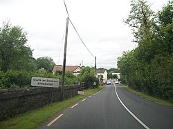
<span class="mw-page-title-main">Ballyhaise</span> Village in County Cavan, Ireland

Ballyhaise is a village in County Cavan, Ireland. It is situated approximately 7 km (4.3 mi) north-northeast of Cavan and 11 km, via the N54, from the border with County Fermanagh in Northern Ireland. The River Annalee flows near the village.

<span class="mw-page-title-main">Laragh, County Cavan</span>

Laragh or Larah is a civil parish in County Cavan, Ireland. The principal village in the civil parish is Stradone which is located 1 km from the N3 national road. Laragh is also an ecclesiastical parish in the Roman Catholic Diocese of Kilmore. There are three churches in the parish namely in Larah, Clifferna and Carrickallen. There are two national schools, at Larah and Clifferna, respectively.

<span class="mw-page-title-main">Haggardstown</span> Townland in Leinster, Ireland

Haggardstown is a townland and civil parish located in the barony of Upper Dundalk, on the southern outskirts of Dundalk, County Louth, Ireland. The civil parish of Haggardstown lies on the shore of Dundalk Bay, north of the estuary of the River Fane, and includes the village of Blackrock and Dundalk Golf Club.

<span class="mw-page-title-main">Portroe</span> Village in County Tipperary, Ireland

Portroe is a village in County Tipperary, Ireland. The village is located on the R494 regional road, 3 km from the eastern shore of Lough Derg and 10 km west of the town of Nenagh. Portroe spans the townlands of Garrykennedy, Glencrue and Shesharoe.

<span class="mw-page-title-main">Brosna, County Offaly</span> Village in Leinster, Ireland

Brosna is a small village and townland in County Offaly, Ireland. It lies in the valley of the Little Brosna River less than one kilometer off the N62 national secondary road. As of the 2011 census, Brosna townland had a population of 31 people. The area takes its named from the Little Brosna River, which flows through the townland.

<span class="mw-page-title-main">Knockbride</span> Parish in County Cavan, Ireland

Knockbride is a civil parish in County Cavan, Ireland. It is located to the north of the town of Bailieborough.

<span class="mw-page-title-main">Clara, County Wicklow</span> Hamlet in County Wicklow, Ireland

Clara or Clara More is a townland and small clachan consisting of a bridge over the Avonmore River and a number of buildings in County Wicklow in Ireland. The village is situated halfway between Laragh and Rathdrum on the R755 road, and is sometimes referred to as the 'smallest village in Ireland'.

Carlanstown is a village and townland in County Meath, Ireland. As of the 2016 census, there were 664 people living in the village.

Aughnacliffe, officially Aghnacliff , is a village in County Longford, Ireland. It is located close to Lough Gowna and the border with County Cavan.

<span class="mw-page-title-main">Rathtoe</span> Village in County Carlow, Ireland

Rathtoe, also spelled Rathoe, is a village and townland in County Carlow, Ireland. The village is located in the civil parish of Gilbertstown, between Tullow and Ballon, County Carlow. The Burren River flows through the area. Rathtoe is a census town, and had a population of 304 as of the 2016 census.

References

  1. 1 2 3 "Sraith an Domhain / Stradone". logainm.ie. Placenames Database of Ireland. Retrieved 19 August 2021.
  2. "Cavan County Development Plan 2014-2020" (PDF). cavancoco.ie. Cavan County Council. Retrieved 19 August 2021.
  3. Archaeological Inventory of County Cavan. Dublin: Government Stationery Office. 1995.
  4. "Co. Cavan, Stradone House". Dictionary of Irish Architects. Irish Architectural Archive. Retrieved 19 August 2021.
  5. 1 2 "Drumlaunaght (Upp. Loughtee By.), Stadone, Stradone, Cavan". buildingsofireland.ie. National Inventory of Architectural Heritage. Retrieved 19 August 2021.
  6. "Stradone House, Drumlaunaght (Upp. Loughtee By.), Stadone, Cavan". buildingsofireland.ie. National Inventory of Architectural Heritage. Retrieved 19 August 2021.
  7. "Stradone Post Office, Clondergan, Stradone, Cavan, Co. Cavan". anpost.ie. An Post. Retrieved 19 August 2021.
  8. "Pump, Drumlaunaght (Upp. Loughtee By.), Stadone, Stradone, Cavan". buildingsofireland.ie. National Inventory of Architectural Heritage. Retrieved 19 August 2021.
  9. "Pump, Drumlaunaght (Upp. Loughtee By.), Stadone, Stradone, Cavan". buildingsofireland.ie. National Inventory of Architectural Heritage. Retrieved 19 August 2021.
  10. "Stradone Garda Síochána Station, Corraneary (Upper Loughtee By.), Stradone, Cavan". buildingsofireland.ie. National Inventory of Architectural Heritage. Retrieved 19 August 2021.
  11. "Office of Public Works Properties - Dáil Éireann Debate, Tuesday - 8 April 2014". oireachtas.ie. Retrieved 19 August 2021.
  12. "Route 166 Timetable" (PDF). Archived from the original (PDF) on 25 October 2012. Retrieved 15 February 2013.