Cornelia Fort Airpark

Last updated
Cornelia Fort Airpark
Cornelia Fort Airpark, 2018.jpg
Summary
Airport typePublic (closed)
OwnerColemill Enterprises
Serves Nashville, Tennessee
Elevation  AMSL 418 ft / 127 m
Coordinates 36°11′25″N086°41′59″W / 36.19028°N 86.69972°W / 36.19028; -86.69972
Runways
Direction LengthSurface
ftm
4/22 (closed)3,5001,067Asphalt
Statistics (2009)
Aircraft operations30,110
Based aircraft27

Cornelia Fort Airpark( FAA LID : M88) was a privately owned, public-use airport located five nautical miles (9 km) northeast of the central business district of Nashville, in Davidson County, Tennessee, United States. [1] It is named in honor of Nashvillian, Cornelia Fort, the first female pilot to be killed on war duty in American history. The airpark was built in 1945 near her family farm. [2] The 141-acre airport was located on part of a plot of land granted to early Nashvillian Ephraim McLean for service in the Revolutionary War, [3] near what is still known as McLean's Bend in the Cumberland River in East Nashville. The airport operated from 1944 until 2011, when the city of Nashville acquired it to include it as non-aviation part of Shelby Park.

Contents

History

The airport was established in 1945 by the Colemill Flying Service and was named for World War II aviator Cornelia Fort. [2]

In the early 1950s Ernest W. Colbert bought out his partner to become sole owner and continued in that capacity (operating it as Colemill Enterprises) until selling it in 2011. [4] Colbert had been seeking a buyer after defaulting on loans of $1 million in 2005 and the second for $1.4 million in 2010 (after it was inundated in the 2010 Tennessee floods. [5] [6] [7]

With the 2011 purchase, the Shelby Park/Shelby Bottoms/Cornelia Fort area has more than 1,300 acres—the fourth largest public greenspace in Nashville (trailing Beaman, Bells Bend and Warner). [8] [9] After the sale, the property would no longer be serving small private planes. [10]

On March 5, 1963, country singers Patsy Cline, Hawkshaw Hawkins, and Cowboy Copas were flying into Cornelia Fort Airpark from Fairfax Airport in Kansas City, Kansas. The owner and pilot of the plane was Copas‘ son in law, and Cline's manager, Randy Hughes. After a stopover at Dyersburg to refuel, Hughes’ Piper Comanche crashed on the flight to Nashville near Camden, Tennessee, about 90 miles from the Cornelia Fort Airpark. [11]

Runway at Cornelia Fort Airpark as seen in 2018. The facility was closed in 2011. Cornelia Fort Airpark runway, 2018.jpg
Runway at Cornelia Fort Airpark as seen in 2018. The facility was closed in 2011.

Musician Earl Scruggs was injured in a night landing of his single-engine plane at the airpark. He was flying solo in his 1974 Cessna Skyhawk II returning from a musical performance in Murray, Kentucky around midnight on September 29, 1975. [12] On his approach descent he encountered fog and overshot the runway. The plane flipped over, but the ELT (Emergency Locator Transmitter) device in the airplane did not trigger. Scruggs remained unattended with a broken ankle, nose, and other injuries for about five hours. [12] Fearing a possible fire, Scruggs was able to crawl about 150 feet from the plane despite his injuries. His family was driving back from the concert in Kentucky and was unaware of the accident, but a niece became worried, called police about 4 AM and went to the airpark where they heard his cry for help near the wreckage. Scruggs recovered from his injuries.

Thirty small planes were damaged at Cornelia Fort Airport during the 1998 tornado outbreak. [13]

Russell W. Brothers, Jr., a Nashville businessman, was familiar with Cornelia Fort Airpark and at one time lived there. [14] At age 75, Brothers was flying a private plane solo at night from Miami, Florida to Dickson, Tennessee on April 20, 2012. After trouble with the landing gear, he made a crash-landing in his 1961 vintage twin-engine Beechcraft airplane at the Cornelia Fort Airpark which was closed at the time. Without functioning landing gear, he made a belly landing on a grassy area. [15] [16] The landing was not violent enough to trigger an alert signal by the airplane's emergency locator transmitter which would have notified authorities. Brothers was not injured and left the scene without notifying authorities. His wife picked him up, and he left the plane there as a mystery. A maintenance worker later saw it, but did not alert authorities until the following morning. [17] The police traced the plane to Brothers and searched his home, where they found 16 firearms. Since he had a prior conviction as a felon 24 years previously, it was unlawful for Brothers to possess firearms. Subsequently, he was convicted of unlawful possession of firearms and obstruction of justice. [14] Brothers pleaded guilty in U.S. District Court to the weapons charge and also to obstruction of a federal investigation, receiving a 15-month jail sentence. [15]

Facilities and aircraft

The airport's former facilities Cornelia fort buildings.jpg
The airport's former facilities

Cornelia Fort Airpark covered an area of 300 acres (121 ha) at an elevation of 418 feet (127 m) above mean sea level. It had one runway designated 4/22 with an asphalt surface measuring 3,500 by 50 feet (1,067 x 15 m).

For the 12-month period ending March 6, 2009, the airport had 30,110 aircraft operations, an average of 82 per day: 95% general aviation and 5% air taxi. At that time there were 27 aircraft based at this airport: 74% single-engine and 26% multi-engine. [1]

Related Research Articles

<span class="mw-page-title-main">Nashville International Airport</span> Airport in Nashville, Tennessee, United States

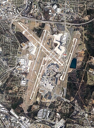
Nashville International Airport is a public/military airport in the southeastern section of Nashville, Tennessee, United States. Established in 1937, its original name was Berry Field, from which its ICAO and IATA identifiers are derived. The current terminal was built in 1987, and the airport took its current name in 1988. Nashville International Airport has four runways and covers 4,555 acres (1,843 ha) of land. It is by far the busiest airport in Tennessee, with more boardings and arrivals than all other airports in the state combined.

<span class="mw-page-title-main">Akron–Canton Airport</span> Airport in Green, Ohio

Akron–Canton Airport is a commercial airport in the city of Green, in southern Summit County, Ohio. The airport is located about 14 miles (23 km) southeast of Akron and 10 miles (16 km) northwest of Canton. It is jointly operated by Summit County and Stark County. The airport is a "reliever" airport for Northeast Ohio and markets itself as "A better way to go", emphasizing the ease of travel in comparison to Cleveland Hopkins International Airport. Just under 90% of its traffic is general aviation. It is included in the Federal Aviation Administration (FAA) National Plan of Integrated Airport Systems for 2019–2023, in which it is categorized as a small-hub primary commercial service facility.

<span class="mw-page-title-main">Dayton–Wright Brothers Airport</span> Airport in Montgomery County / Clearcreek Township, Warren County

Dayton–Wright Brothers Airport is a public airport located 10 miles (16 km) south of the central business district of Dayton, Ohio, located mainly in Miami Township, Montgomery County and partly in Clearcreek Township, Warren County, near the suburb of Springboro. It is owned and operated by the City of Dayton and serves as the reliever airport for Dayton International Airport. It mainly serves corporate and personal aircraft users. The airport's identifying code, MGY, is a reference to its former name of Montgomery County Airport.

Delaware Airpark is a public use airport serving the Dover area. It is owned by the Delaware Department of Transportation and operated by the Delaware River and Bay Authority and located one nautical mile (2 km) west of the central business district of Cheswold, a town in Kent County, Delaware, United States. It is included in the Federal Aviation Administration (FAA) National Plan of Integrated Airport Systems for 2017–2021, in which it is categorized as a local general aviation facility.

Shelby County Airport is a public airport located three miles (4.8 km) west of the central business district (CBD) of Shelbyville, a city in Shelby County, Illinois, United States. A significant amount of the airport's traffic is from agricultural aviation serving nearby areas.

<span class="mw-page-title-main">Katama Airpark</span> Airport in Edgartown, Massachusetts

Katama Airpark is a public airport in the Katama section of Edgartown, Massachusetts, in Dukes County on the island of Martha's Vineyard. The airport, owned by the Town of Edgartown, has three runways, averages 22 takeoffs and landings per day, and has one aircraft based on its field.

<span class="mw-page-title-main">Cornelia Fort</span>

Cornelia Clark Fort was a United States aviatrix who became famous for being part of two aviation-related events. The first occurred while conducting a civilian training flight at Pearl Harbor on December 7, 1941, when she was the first United States pilot to encounter the Japanese air fleet during the Attack on Pearl Harbor. She and her student narrowly escaped a mid-air collision with the Japanese aircraft and a strafing attack after making an emergency landing.
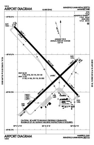
<span class="mw-page-title-main">Ohio State University Airport</span> Airport in Columbus, United States of America

Ohio State University Airport is a public airport six miles (10 km) northwest of downtown Columbus, in Franklin County, Ohio, United States. It is owned and operated by Ohio State University in Columbus. It is also known as the OSU Don Scott Airport, named after Donald E. Scott, an OSU alumnus who died during his training as a pilot in the United Kingdom during World War II. The airport's main entrance is located on Case Road, and is easily accessible from OH-315 and Interstate 270.

<span class="mw-page-title-main">Smyrna Airport (Tennessee)</span> Airport in Smyrna, TN, US

Smyrna Airport is a public general aviation and military use airport located two nautical miles (4 km) north of the central business district of Smyrna, a town in Rutherford County, Tennessee, United States. It is owned by the Smyrna / Rutherford County Airport Authority. Smyrna Airport is the third largest airport in Tennessee and is the state's busiest general aviation airport. Prior to March 1971, the facility was an active military installation known as Sewart Air Force Base.

<span class="mw-page-title-main">Fallbrook Community Airpark</span> Airport

Fallbrook Community Airpark, also known as Fallbrook Airpark, is a county-owned public-use airport located two nautical miles south of the central business district of Fallbrook, in San Diego County, California, United States.

Destin Executive Airport, also known as Coleman Kelly Field, is a public use airport owned by and located in Okaloosa County, Florida. The airport is one nautical mile (2 km) east of the central business district of Destin, Florida. It is included in the National Plan of Integrated Airport Systems for 2021–2025, which categorized it as a general aviation facility.

<span class="mw-page-title-main">Moraine Airpark</span> Airport in Moraine, Ohio

Moraine Airpark is a public-use airport situated in the city of Moraine, Ohio, United States. 4 miles (6.4 km) southwest of the city of Dayton in Montgomery County. The Airpark originally was called South Dayton Airport which was originally located on Stroop Rd and Lamme Rd in from 1941-1954. It's moved to its current location in 1955 and has been open to the public for the last 68 years (2023). They have everything from a Fairchild to a Christian Eagle based here.Careflight has a hanger for maintenance based there as well. The airpark is the first home base of the National Waco Club. It is also home to a chapter of the Experimental Aircraft Association, which it self holds Young Eagles Days where young pilots are taken for free airplane rides.

Grand Haven Memorial Airpark is a public airport owned and operated by the City of Grand Haven located 2 miles (3.2 km) southeast of Grand Haven, Michigan. The airport is uncontrolled, and is used for general aviation purposes. It is included in the Federal Aviation Administration (FAA) National Plan of Integrated Airport Systems for 2017–2021, in which it is categorized as a local general aviation facility.

<span class="mw-page-title-main">Shelby Park (Nashville)</span>

Shelby Park is a large urban park located approximately three miles east of downtown Nashville along the Cumberland River. The park includes playgrounds, a dog park, baseball fields, two golf courses, and a community center. The park is located between the Lockeland Springs, Shelby Hills, and Rolling Acres neighborhoods. Until the 2011 opening of E. S. Rose Park, the Belmont Bruins baseball team played a portion of its home games at the park. The park includes over 361 acres (1.46 km2) of land.

Elizabethton Municipal Airport is three miles east of Elizabethton, in Carter County, Tennessee. The National Plan of Integrated Airport Systems for 2011–2015 categorized it as a general aviation airport.

<span class="mw-page-title-main">Falls Church Airpark</span> Airport in Fairfax County, Virginia

Falls Church Airpark was an airport located in the Falls Church area of Fairfax County, Virginia from 1945 to 1961. The facility was located on a parcel of land owned by Eakin Properties, a Virginia real estate development firm. The airport was primarily used for general aviation and civil defense purposes until encroaching residential development forced its closure. The area formerly occupied by the airport is now mainly used as a shopping center with the western end of the complex occupied by the Thomas Jefferson branch of the Fairfax County Public Library system. Parts of several apartment complexes are also located on some of the airport's former grounds.

<span class="mw-page-title-main">1963 Camden PA-24 crash</span> Aviation crash in 1963

On March 5, 1963, American country music performers Patsy Cline, Cowboy Copas, and Hawkshaw Hawkins were killed in an airplane crash near Camden, Tennessee, United States, along with the pilot Randy Hughes. The accident occurred as the three artists were returning home to Nashville, Tennessee, after performing in Kansas City, Kansas.

<span class="mw-page-title-main">Russell Brothers</span>

Russell Brothers, born Russell White Brothers, Jr., is an American businessman in Nashville, Tennessee.

Andrews University Airpark is a privately owned, public use airport located 2 miles west of Berrien Springs, Michigan. It is owned and managed by Andrews University, a Seventh Day Adventist university that manages an aviation department.

References

  1. 1 2 3 "M88 - Cornelia Fort Airpark - FAA information effective September 23, 2010". FAA data republished by AirNav. Archived from the original on October 23, 2010.
  2. 1 2 "Cornelia Fort Airport - Historical Commission of Metropolitan Nashville and Davidson County". waymarking.com. Tennessee Historical Markers. March 10, 2006. Retrieved December 10, 2017.
  3. Drake, Doug, with Jack Masters and Bill Puryear. Founding of the Cumberland Settlements: The First Atlas, 1779 - 1804. Sponsored by Sumner County, Tennessee Historical Society and published by Warioto Press, 2009, p. D8.
  4. "Tennessee Aviation Network". Tn-aviation.org. Retrieved January 31, 2012.
  5. Mitchell, Mike (September 11, 2011). "Cornelia Fort Airpark Has New Owner". AvStop.com. Retrieved January 31, 2012.
  6. Williams III, G. Chambers (May 5, 2010). "Cornelia Fort Airpark, airplanes, inundated by floodwaters". The Tennessean . Retrieved May 7, 2012.
  7. Pew, Glenn (May 6, 2010). "Tennessee Airpark Ravaged By Flood". AVweb.com. Retrieved January 31, 2012.
  8. "Help The Land Trust for Tennessee Protect the Cornelia Fort Airpark". LandTrustTN.org. Archived from the original on July 17, 2011. Retrieved January 31, 2012.
  9. Garrison, Joey (March 31, 2011). "Shelby Bottoms could expand with purchase of 132-acre airpark". Nashville City Paper. Archived from the original on July 19, 2013. Retrieved January 31, 2012.
  10. Garrison, Joey (April 5, 2011). "Park Board Approves $1.2M Purchase of Cornelia Fort Airpark". The City Paper. Archived from the original on 4 March 2016. Retrieved 26 July 2015.
  11. Henry, Gerald (March 7, 1963). "Stars Cautioned Against Winds". Vol. 57, no. 30–9. The Nashville Tennessean. Retrieved December 10, 2017.
  12. 1 2 Thompson, Jerry (September 30, 1975). "Earl Scruggs Suffers Multiple Injuries in Small Plane Crash". Vol. 70, no. 176. The Tennessean. p. 1.
  13. "Tornado outbreak of April 15–16, 1998", Wikipedia, 2020-04-11, retrieved 2020-04-18
  14. 1 2 "Drug-Smuggler Russell W. Brothers Jr. Headed Back to Prison After Plea to Weapons Charges". wdkn.com. R & F Communications. October 27, 2014. Archived from the original on 22 December 2015. Retrieved 1 December 2015.
  15. 1 2 Gonzales, Tony (October 24, 2014). "Notorious drug smuggling pilot, 77, guilty on gun charges". tennessean.com. Gannett Corp. Retrieved 22 November 2015.
  16. "Russell Brothers Indicted on Federal Weapons, Obstruction Charges". nashvillecitypaper.com. Southcomm. March 6, 2013. Archived from the original on 22 December 2015. Retrieved 1 December 2015.
  17. "Noted ex-drug smuggler crash-landed plane into closed airpark". nashvillecitypaper.com. SouthComm Communications. April 23, 2012. Archived from the original on 22 December 2015. Retrieved 30 November 2015.