
The Cornerstone of Peace is a monument in Itoman commemorating the Battle of Okinawa and the role of Okinawa during World War II. The names of over two hundred and forty thousand people who lost their lives are inscribed on the memorial.
The Cornerstone of Peace is a monument in Itoman commemorating the Battle of Okinawa and the role of Okinawa during World War II. The names of over two hundred and forty thousand people who lost their lives are inscribed on the memorial.
The Cornerstone of Peace (平和の礎, Heiwa no Ishiji) was unveiled on 23 June 1995 in memory of the fiftieth anniversary of the Battle of Okinawa and the end of World War II. [1] [2] It was erected to: (1) Remember those lost in the war, and pray for perpetual peace; (2) Pass on the lessons of war; and (3) Serve as a place for meditation and learning. [1] [2]
Constructed by the administration of Masahide Ōta, and as detailed in his book of the same name Okinawa: Heiwa no Ishiji, the name 'Cornerstone of Peace' alludes to the Japan-US security partnership. [3] Ōta writes 'It would not be an exaggeration to say that the motivation which led to the building of this 'Cornerstone of Peace' has also become the basis for the people of Okinawa devoting heart and soul, night and day, to solving the military base issue.' [3] When US President Bill Clinton visited the Cornerstone of Peace in 2000 he delivered a speech promising efforts to reduce and consolidate US bases in Okinawa, as previously agreed by the US and Japanese governments. [4]


The winning design, entitled 'Everlasting Waves of Peace', comprises concentric arcs of wavelike black granite stelai or screens. [2] [3] These are inscribed with the names of all those who died, regardless of nationality and civilian or military status. The names are in horizontal order from left to right, and in their native alphabet according to place of origin. [1] [2] [5] The series totals some 116 stones, with the text running a total length of 2,200 metres (7,200 ft). [6]
As of June 2015, there were 241,281 names. [7] By order of inscription are 77,380 from other prefectures of Japan, by prefecture; 149,329 from Okinawa Prefecture, by hamlet; 14,009 from the USA, by unit; 82 from the UK; 365 from the Republic of Korea; 82 from North Korea; and 34 from Taiwan. [5] [7] The numbers correspond to recorded deaths during the Battle of Okinawa from the time of the US landings in the Kerama Islands on 26 March 1945 to the signing of the Japanese surrender on 2 September 1945, in addition to all Okinawan casualties in the Pacific War in the fifteen years from the Manchurian Incident, along with those who died in Okinawa from war-related events in the year before the battle and the year after the surrender. [5] 234,183 names were inscribed by the time of unveiling and new names are added each year. [2] [3] [8]

The site chosen for the memorial is Mabuni Hill in Itoman City, site of the Japanese headquarters and scene of heavy fighting in late June 1945 at the end of the Battle of Okinawa. [2] [9] [10] The area forms part of the Okinawa Senseki Quasi-National Park (沖縄戦跡国定公園). [11]
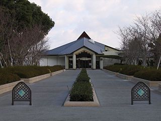
The Okinawa Prefectural Peace Memorial Museum (沖縄県平和祈念資料館 Okinawa Kenritsu Heiwa Kinen Shiryōkan) was opened in 1975. [12] [13]
In 2001 the Okinawa Peace Prize was established in order to recognize local contributions to peace in the Asia-Pacific region. [14]
The Centre for the Study of Pacific War Memories at the University of California Santa Cruz is developing a visualization project in order to reproduce virtually the Cornerstone of Peace while making use of recently declassified photographs from the archives of the Department of Defense. [15]

The Battle of Okinawa, codenamed Operation Iceberg, was a major battle of the Pacific War fought on the island of Okinawa by United States Army and United States Marine Corps forces against the Imperial Japanese Army. The initial invasion of Okinawa on 1 April 1945 was the largest amphibious assault in the Pacific Theater of World War II. The Kerama Islands surrounding Okinawa were preemptively captured on 26 March by the 77th Infantry Division. The 82-day battle lasted from 1 April until 22 June 1945. After a long campaign of island hopping, the Allies were planning to use Kadena Air Base on the large island of Okinawa as a base for Operation Downfall, the planned invasion of the Japanese home islands, 340 mi (550 km) away.

Okinawa Prefecture is the southernmost and westernmost prefecture of Japan. It has a population of 1,457,162 and a geographic area of 2,281 km2.
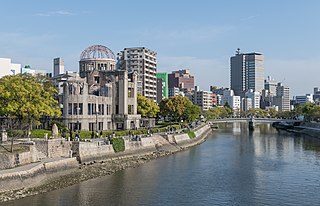
Hiroshima is the capital of Hiroshima Prefecture in Japan. As of June 1, 2019, the city had an estimated population of 1,199,391. The gross domestic product (GDP) in Greater Hiroshima, Hiroshima Urban Employment Area, was US$61.3 billion as of 2010. Kazumi Matsui has been the city's mayor since April 2011. The Hiroshima metropolitan area is the second largest urban area in the Chugoku Region of Japan, following the Okayama metropolitan area.

The Hiroshima Peace Memorial, originally the Hiroshima Prefectural Industrial Promotion Hall, and now commonly called the Genbaku Dome, Atomic Bomb Dome or A-Bomb Dome, is part of the Hiroshima Peace Memorial Park in Hiroshima, Japan and was designated a UNESCO World Heritage Site in 1996.

Itoman is a city located in Okinawa Prefecture, Japan. The city occupies the southern tip of Okinawa Island. As of 1 October 2020, the city has an estimated population of 61,007 and a population density of 1,308.32 inhabitants per square kilometre (3,388.5/sq mi). The total area is 46.63 km2 (18.00 sq mi).

Minoru Ōta was an admiral in the Imperial Japanese Navy during World War II, and the final commander of the Japanese naval forces defending the Oroku Peninsula during the Battle of Okinawa.
Haebaru is a town located in Shimajiri District, Okinawa Prefecture, Japan.

Masahide Ōta was a Japanese academic and politician who served as the governor of Okinawa Prefecture from 1990 until 1998. After starting his career as a professor at the University of the Ryūkyūs, he wrote books in English and Japanese, mostly about the Battle of Okinawa and Japan–United States bilateral relations following World War II. After his retirement as professor he was elected as governor and was best known for his strong stand against occupation of prefectural lands by military bases of United States, going against the Japanese central government at the time.
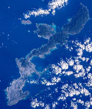
Okinawa Island, officially Okinawa Main Island, is the largest of the Okinawa Islands and the Ryukyu (Nansei) Islands of Japan in the Kyushu region. It is the smallest and least populated of the five main islands of Japan. The island is approximately 106 kilometres (66 mi) long, an average 11 kilometres (7 mi) wide, and has an area of 1,206.98 square kilometers (466.02 sq mi). It is roughly 640 kilometres south of the main island of Kyushu and the rest of Japan. It is 500 km northeast of Taiwan. The total population of Okinawa Island is 1,384,762. The greater Naha area has roughly 800,000 residents, while the city itself has about 320,000 people. Naha is the seat of Okinawa Prefecture on the southwestern part of Okinawa Island. Okinawa has a humid subtropical climate.

Rail transport in Okinawa consists of only the Okinawa Urban Monorail, the only rail line providing rail transportation in Okinawa Prefecture. In the past, Okinawa Island had railroad, trams, and horse-drawn streetcar service. Moreover, Minamidaitōjima and other islands had rail lines to transport sugarcane and other commodities.

Peace Boulevard is one of the main streets in Hiroshima, Japan, which faces the south side of Hiroshima Peace Memorial Park.
Yukka nu hii is an annual festival of the Okinawa Islands of southwestern Japan, which is traditionally celebrated on the 4th day of the 5th month of the lunisolar calendar. It centers on the traditional dragon boat races. The festival dates back to circa 1400, where it is said to have been adopted from the Chinese. The dragon boat races are a form of giving thanks to the sea and agricultural gods and asking for their continued help for the future.
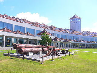
Okinawa Prefectural Peace Memorial Museum is a museum in Itoman, Okinawa. It was established on June 11, 1975. The Cornerstone of Peace, a monument similar to the Vietnam Veterans Memorial, is located here.

Okinawa Senseki Quasi-National Park is a Quasi-National Park around the battlefields of south Okinawa, Japan. It was established as a Prefectural Park in 1965 and redesignated with the return of Okinawa to Japanese administration in 1972.
The airbase at Chiran, Minamikyūshū, on the Satsuma Peninsula of Kagoshima, Japan, served as the departure point for hundreds of Special Attack or kamikaze sorties launched in the final months of World War II. A peace museum dedicated to the pilots, the Chiran Peace Museum for Kamikaze Pilots, now marks the site.
Okinawa Memorial Day is a public holiday observed in Japan's Okinawa Prefecture annually on June 23 to remember the lives lost during the Battle of Okinawa. It is not celebrated nationally throughout Japan. The Battle of Okinawa was the only ground engagement of the Pacific War fought on Japanese soil. Over 240,000 people died and numerous buildings on the island were destroyed along with countless historical documents, artifacts and cultural treasures. It is estimated that about the half of the war victims were local Okinawan residents, among them children.

Bansei Tokkō Peace Museum is a war museum in Minamisatsuma, Kagoshima Prefecture. Opened in 1993, the museum commemorates the 201 airmen from the Bansei Air Base (万世飛行場) who died in a kamikaze attack in the final months of the Pacific War. Hichiro Naemura, a flight instructor at the Bansei base in 1945, spearheaded the effort to establish this institution as a memorial to his fallen comrades.
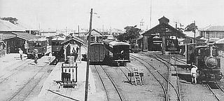
Okinawa Prefectural Railways was the railway operated by the Okinawa Prefectural Government on Okinawa Island from 1914 to 1945. Locally called the Keebin, it operated about 48 kilometers of 2 ft 6 in gauge light railway until it was destroyed in the Battle of Okinawa.

Himeyuri Peace Museum opened in Itoman, Okinawa Prefecture, Japan in 1989. Located within Okinawa Senseki Quasi-National Park, it is dedicated to the Himeyuri Student Corps during the Battle of Okinawa and to the ideal of Peace.
Naval Base Okinawa, now Naval Facility Okinawa, is a number of bases built after the Battle of Okinawa by United States Navy on Okinawa Island, Japan. The naval bases were built to support the landings on Okinawa on April 1, 1945, and the troops fighting on Okinawa. The Navy repaired and did expansion of the airfields on Okinawa. United States Navy Seabees built or repaired the facilities on the island. The bases on Okinawa put the United States Armed Forces only 350 miles from Japan's home islands. Most facilities closed after the war, but some are still in use today by all branches of the United States Armed Forces.
{{cite journal}}: Cite journal requires |journal= (help)