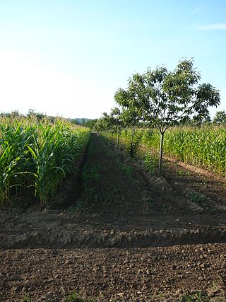
Vegetable farming is the growing of vegetables for human consumption. The practice probably started in several parts of the world over ten thousand years ago, with families growing vegetables for their own consumption or to trade locally. At first manual labour was used but in time livestock were domesticated and the ground could be turned by the plough. More recently, mechanisation has revolutionised vegetable farming with nearly all processes being able to be performed by machine. Specialist producers grow the particular crops that do well in their locality. New methods—such as aquaponics, raised beds and cultivation under glass—are used. Marketing can be done locally in farmer's markets, traditional markets or pick-your-own operations, or farmers can contract their whole crops to wholesalers, canners or retailers.

Field of Dreams is a 1989 American sports fantasy drama film written and directed by Phil Alden Robinson, based on Canadian novelist W. P. Kinsella's 1982 novel Shoeless Joe. The film stars Kevin Costner as a farmer who builds a baseball field in his cornfield that attracts the ghosts of baseball legends, including Shoeless Joe Jackson and the Chicago Black Sox. Amy Madigan, James Earl Jones and Burt Lancaster also star.

Corrales is a village in southern Sandoval County, New Mexico, United States. First farmed by Tiquex Pueblo people, chosen due to its proximity to the Rio Grande, as documented by Hispano farmers of Nuevo México in the late 1500s. Despite being a part of the Albuquerque metropolitan area, the village maintains its rural character, while also being surrounded by the cities of Albuquerque and Rio Rancho. The population of Corrales was 8,329 at the 2010 Census.

Transhumance is a type of pastoralism or nomadism, a seasonal movement of livestock between fixed summer and winter pastures. In montane regions, it implies movement between higher pastures in summer and lower valleys in winter. Herders have a permanent home, typically in valleys. Generally only the herds travel, with a certain number of people necessary to tend them, while the main population stays at the base. In contrast, horizontal transhumance is more susceptible to being disrupted by climatic, economic, or political change.

A cash crop, also called profit crop, is an agricultural crop which is grown to sell for profit. It is typically purchased by parties separate from a farm. The term is used to differentiate marketed crops from staple crop in subsistence agriculture, which are those fed to the producer's own livestock or grown as food for the producer's family.
Land reform in Zimbabwe officially began in 1980 with the signing of the Lancaster House Agreement, as a program to redistribute farmland from white Zimbabweans to black Zimbabweans as an effort by the ZANU-PF government to give more control over the country's extensive farmlands to the black African majority. Before the implementation of these policies, the distribution of land in what was then known as Rhodesia saw a population of 4,400 white Rhodesians owning 51% of the country's land while 4.3 million black Rhodesians owned 42%, with the remainder being non-agricultural land. The discrepancy of this distribution, as well as the overall dominance of the white population in the newly-independent but largely unrecognized Rhodesian state was challenged by the black nationalist organizations ZANU and ZAPU in the Rhodesian Bush War. At the establishment of the modern Zimbabwean state in 1980 after the bush war, the Lancaster House Agreement held a clause that prohibited forced transfer of land, this resulted in changes in land distribution from the willing sale or transfer by owners being minor until 2000, when the government of Robert Mugabe began a more aggressive policy.

The Mississippi Delta, also known as the Yazoo–Mississippi Delta, or simply the Delta, is the distinctive northwest section of the U.S. state of Mississippi that lies between the Mississippi and Yazoo rivers. The region has been called "The Most Southern Place on Earth", because of its unique racial, cultural, and economic history.

Sharecropping is a legal arrangement in which a landowner allows a tenant (sharecropper) to use the land in return for a share of the crops produced on that land. Sharecropping is not to be conflated with tenant farming, providing the tenant a higher economic and social status.

Victory gardens, also called war gardens or food gardens for defense, were vegetable, fruit, and herb gardens planted at private residences and public parks in the United States, United Kingdom, Canada, Australia and Germany during World War I and World War II. In wartime, governments encouraged people to plant victory gardens not only to supplement their rations but also to boost morale. They were used along with rationing stamps and cards to reduce pressure on the food supply. Besides indirectly aiding the war effort, these gardens were also considered a civil "morale booster" in that gardeners could feel empowered by their contribution of labor and rewarded by the produce grown. This made victory gardens a part of daily life on the home front.

Soil fertility refers to the ability of soil to sustain agricultural plant growth, i.e. to provide plant habitat and result in sustained and consistent yields of high quality. It also refers to the soil's ability to supply plant/crop nutrients in the right quantities and qualities over a sustained period of time. A fertile soil has the following properties:

A market garden is the relatively small-scale production of fruits, vegetables and flowers as cash crops, frequently sold directly to consumers and restaurants. The diversity of crops grown on a small area of land, typically from under 0.40 hectares to some hectares, or sometimes in greenhouses, distinguishes it from other types of farming. A market garden is sometimes called a truck farm in the USA.

Middelburg is a large farming and industrial town in the South African province of Mpumalanga.
Agroforestry is a land use management system that integrates trees with crops or pasture. It combines agricultural and forestry technologies. As a polyculture system, an agroforestry system can produce timber and wood products, fruits, nuts, other edible plant products, edible mushrooms, medicinal plants, ornamental plants, animals and animal products, and other products from both domesticated and wild species.

Elgin is a large, lush area of land, circled by mountains, in the Overberg region of South Africa. This broad upland valley lies about 70 km southeast of Cape Town, just beyond the Hottentots Holland Mountains.
Ujamaa was a socialist ideology that formed the basis of Julius Nyerere's social and economic development policies in Tanzania after it gained independence from Britain in 1961.
Lwandle/Nomzamo is a small township in the Helderberg basin just outside Strand in the Western Cape of South Africa. Both names are sometimes used interchangeably referring to both places. This may be attributed to the fact that Nomzamo was born as a result of overpopulation in Lwandle area which initially designed as a cheap accommodation for "single male workers" during the apartheid years.

Bermuda Hundred was the first administrative division in the English colony of Virginia. It was founded by Sir Thomas Dale in 1613, six years after Jamestown. At the southwestern edge of the confluence of the Appomattox and James Rivers opposite City Point, annexed to Hopewell, Virginia in 1923, Bermuda Hundred was a port town for many years. The terminology "Bermuda Hundred" also included a large area adjacent to the town. In the colonial era, "hundreds" were large developments of many acres, arising from the English term to define an area which would support 100 homesteads. The port at the town of Bermuda Hundred was intended to serve other "hundreds" in addition to Bermuda Hundred.

Grabouw is a town located in the Western Cape province of South Africa. Grabouw is located some 65 km south-east of Cape Town, over Sir Lowry's Pass from Somerset West, along the N2 highway. The town is the commercial centre for the vast Elgin Valley, the largest single export fruit-producing area in Southern Africa, which extends between the Hottentots-Holland, Kogelberg, Groenland, and Houwhoek Mountains. The town's population has grown rapidly, with 44 593 people in 2019 from 21 593 as listed by the 2001 census.
Edendale is a township in Msunduzi local municipality in the KwaZulu-Natal province of South Africa.

The Black Belt in the American South refers to the social history, especially concerning slavery and black workers, of the geological region known as the Black Belt. The geology emphasizes the highly fertile black soil. Historically, the black belt economy was based on cotton plantations – along with some tobacco plantation areas along the Virginia-North Carolina border. The valuable land was largely controlled by rich whites, and worked by very poor, primarily black slaves who in many counties constituted a majority of the population. Generally the term is applied to a larger region than that defined by its geology.


