
Soweto is a township of the City of Johannesburg Metropolitan Municipality in Gauteng, South Africa, bordering the city's mining belt in the south. Its name is an English syllabic abbreviation for South Western Townships. Formerly a separate municipality, it is now incorporated in the City of Johannesburg Metropolitan Municipality, Suburbs of Johannesburg.

Mfecane, also known by the Sesotho name Difaqane or Lifaqane, was a period of widespread chaos and warfare among indigenous ethnic communities in southern Africa during the period between 1815 and about 1840.

The Tugela River is the largest river in KwaZulu-Natal Province, South Africa. It is one of the most important rivers of the country.

Estcourt is a town in the uThukela District of KwaZulu-Natal Province, South Africa. The main economic activity is farming with large bacon and processed food factories situated around the town. The N3 freeway passes close to the town, linking it to the rest of South Africa.

Alexandra, informally abbreviated to Alex, is a township in the Gauteng province of South Africa. It forms part of the city of Johannesburg and is located near the upper-class suburb of Sandton. Alexandra is bounded by Wynberg on the west, Marlboro and Kelvin on the north, Kew, Lombardy West and Lombardy East on the south. It is commonly known as "Gomorrah" among local residents. Alexandra is one of the poorest urban areas in the country. Alexandra is situated on the banks of the Jukskei River. In addition to its original, reasonably well-built houses, it also has a large number of informal dwellings or "shacks".

Colenso is a town in KwaZulu-Natal, South Africa. It is located on the southern bank of the Tugela River. The original settlement was contained within a loop on the river, but it subsequently expanded southwards and eastwards. It lies on the main Durban - Johannesburg railway line some 190 km (118 mi) north-west of Durban.
In South Africa, pass laws were a form of internal passport system designed to segregate the population, manage urbanisation, and allocate migrant labour. Also known as the natives law, pass laws severely limited the movements of not only black African citizens, but other people as well by requiring them to carry pass books when outside their homelands or designated areas. Before the 1950s, this legislation largely applied to African men, and attempts to apply it to women in the 1910s and 1950s were met with significant protests. Pass laws would be one of the dominant features of the country's apartheid system, until it was effectively ended in 1986.

Apartheid was a system of institutionalised racial segregation that existed in South Africa and South West Africa (Namibia) from 1948 until the early 1990s. Apartheid was characterised by an authoritarian political culture based on baasskap, which ensured that South Africa was dominated politically, socially, and economically by the nation's minority white population. According to this system of social stratification, white citizens had the highest status, followed in descending order by Asians, Coloureds, and black Africans. The economic legacy and social effects of apartheid continue to the present day.

The Black Seminoles are black Indians associated with the Seminole people in Florida and Oklahoma. They are mostly blood descendants of the Seminole people, free blacks and of escaped slaves who allied with Seminole groups in Spanish Florida. Many have Seminole lineage, but due to the stigma of having dark skin, they all have been categorized as slaves or freedmen.
Ga-Rankuwa is a large settlement located about 37 km north of Pretoria. Provincially it is in Gauteng province, but it used to fall in Bophuthatswana during the apartheid years.

The Natives Land Act, 1913 was an Act of the Parliament of South Africa that was aimed at regulating the acquisition of land.
The system of racial segregation in South Africa known as apartheid was implemented and enforced by many acts and other laws. This legislation served to institutionalise racial discrimination and the dominance by white people over people of other races. While the bulk of this legislation was enacted after the election of the National Party government in 1948, it was preceded by discriminatory legislation enacted under earlier British and Afrikaner governments. Apartheid is distinguished from segregation in other countries by the systematic way in which it was formalised in law.
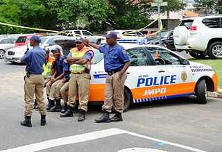
Law enforcement in South Africa is primarily the responsibility of the South African Police Service (SAPS), South Africa's national police force. SAPS is responsible for investigating crime and security throughout the country. The "national police force is crucial for the safety of South Africa's citizens" and was established in accordance with the provisions of Section 205 of the Constitution of South Africa.

The Kingdom of Zulu, sometimes referred to as the Zulu Empire or the Kingdom of Zululand, was a monarchy in Southern Africa that extended along the coast of the Indian Ocean from the Tugela River in the south to Pongola River in the north.

Land reform is an important political and economic topic in Namibia. It consists of two different strategies: resettlement, and transfer of commercially viable agricultural land. Resettlement is aimed at improving the lives of displaced or dispossessed previously disadvantaged Namibians. Farms obtained by government for resettlement purposes are usually split into several sections, and dozens of families are being resettled on what had previously been one farm. Transfer of commercial agricultural land is not directly conducted by government. Would-be farmers with a previously disadvantaged background obtain farms privately or through affirmative action loans. In both cases, the "Willing buyer, willing seller" principle applies.

The Natives Resettlement Act, Act No 19 of 1954, formed part of the apartheid system of racial segregation in South Africa. It permitted the removal of blacks from any area within and next to the magisterial district of Johannesburg by the South African government. This act was designed to remove of blacks from Sophiatown to Meadowlands.
The Native Trust and Land Act, 1936 in South Africa passed a law that served as the reorganization of its agricultural structures. This followed the recommendations of the Beaumont Commission.
Vrededorp is a suburb of Johannesburg, South Africa. It is located in Region F of the City of Johannesburg Metropolitan Municipality. Vrededorp is situated on the North-Western side of Johannesburg and is 1,764 m (5,788 ft) above sea level.
Agrarian reform and land reform have been a recurring theme of enormous consequence in world history. They are often highly political and have been achieved in many countries.
Land reform in South Africa is the promise of "land restitution" to empower farm workers and reduce inequality. It is believed to allow previously unemployed people to participate in the economy and better the country's economic growth. It also relates to restitution in the form of settling Land Claims of people who were forcefully removed from their homes in urban areas that were declared white, by the apartheid government's segregationist Group Areas Act: such areas include Sophiatown, Fietas, Cato Manor, District Six and Greyville; as well as to restitution for people forcibly evicted from rural land because of apartheid policies.


