Cornwall Gardens

Last updated

Cornwall Gardens Plane tree, Cornwall Gardens - geograph.org.uk - 464530.jpg
Cornwall Gardens

Cornwall Gardens is a long narrow garden square in South Kensington, London, England.

The street runs east–west off Gloucester Road and crosses Launceston Place.

The ownership of the holdings and land of what is now Cornwall gardens can be traced back to the sixteenth century, Anciently, the thin block of land stretching westwards from Gloucester Road to the Edwardes estate comprised two copyholds belonging to the manor of Earl's Court, amounting together to nearly eleven acres. The smaller portion next to Gloucester Road (formerly Hogmore or Hogmire Lane) was known as Church Close, the larger, more westerly portion as Long Mead, and the division between them was an old footpath, Love Lane, now represented by the line of Launceston Place and Grenville Place and its continuation through Cornwall Gardens. By 1680 they were in the same hands.

Purchased by John Broadwood in the early 1800s, it continued as a market garden until it came into possession of Thomas Broadwood Junior (1821-81) in 1844. Under the instruction of Broadwood, it was developed from 1862 to 1879 by (1862–76) Welchman and Gale from 1862 to 1876 and from 1876 to 1879 by William Willett. [1]

The Penfold pillar box on the north side of the gardens. Cornwall Gardens, SW7 (2) - geograph.org.uk - 850560.jpg
The Penfold pillar box on the north side of the gardens.

The buildings of Cornwall Gardens are listed Grade II on the National Heritage List for England in groups as 6–16, [2] 17–44, [3] 55–82, [4] and 83–93. [5] The pair of houses at the west end of the middle of the garden square, Cornwall House and Garden House, are jointly listed Grade II, as are the railings that surround the houses. [6]

The 1860s Penfold pillar box on the north side of the gardens is listed Grade II. [7]

Stanford court, 45 is an elegant 1930s block home to several eminent residents.

Kynance Mews to the north of the square was originally built as stabling for the Cornwall Gardens development between 1862 and 1879. [8] [1]

Notable residents

Related Research Articles

Earl's Court is a district of Kensington in the Royal Borough of Kensington and Chelsea in West London, bordering the rail tracks of the West London line and District line that separate it from the ancient borough of Fulham to the west, the sub-districts of South Kensington to the east, Chelsea to the south and Kensington to the northeast. It lent its name to the now defunct eponymous pleasure grounds opened in 1887 followed by the pre–World War II Earls Court Exhibition Centre, as one of the country's largest indoor arenas and a popular concert venue, until its closure in 2014.

<span class="mw-page-title-main">Buckingham Palace Garden</span> Garden in London

Buckingham Palace Garden is a large private park attached to the London residence of the monarch. It is situated to the rear (west) of Buckingham Palace, occupying a 17 hectares site in the City of Westminster and forms the largest private garden in the capital. It is bounded by Constitution Hill to the north, Hyde Park Corner to the west, Grosvenor Place to the south-west, and the Royal Mews, Queen's Gallery, and Buckingham Palace itself to the south and east.

Sir James Pennethorne was a British architect and planner, particularly associated with buildings and parks in central London.

<span class="mw-page-title-main">Barnwell Manor</span>

Barnwell Manor is a Grade II listed country estate near the village of Barnwell, about 2.5 miles (4.0 km) south of Oundle, in Northamptonshire, England. The historic former home of the Duke and Duchess of Gloucester, as of 2017 it was occupied by Windsor House Antiques. In September 2022, Prince Richard, Duke of Gloucester, put the manor up for sale for £4.75 million.

<span class="mw-page-title-main">Gloucester Road, London</span>

Gloucester Road (B325) is a street in the Royal Borough of Kensington and Chelsea, London. It runs north–south between Kensington Gardens and Old Brompton Road.

Brompton, sometimes called Old Brompton, survives in name as a ward in the Royal Borough of Kensington and Chelsea in London. Until the latter half of the 19th century it was a scattered village made up mostly of market gardens in the county of Middlesex. It lay south-east of the village of Kensington, abutting the parish of St Margaret's, Westminster at the hamlet of Knightsbridge to the north-east, with Little Chelsea to the south. It was bisected by the Fulham Turnpike, the main road westward out of London to the ancient parish of Fulham and on to Putney and Surrey. It saw its first parish church, Holy Trinity Brompton, only in 1829. Today the village has been comprehensively eclipsed by segmentation due principally to railway development culminating in London Underground lines, and its imposition of station names, including Knightsbridge, South Kensington and Gloucester Road as the names of stops during accelerated urbanisation, but lacking any cogent reference to local history and usage or distinctions from neighbouring settlements.

<span class="mw-page-title-main">Hans Place</span>

Hans Place is a garden square in the Knightsbridge district of the Royal Borough of Kensington and Chelsea, London, immediately south of Harrods in SW1. It is named after Sir Hans Sloane, 1st Baronet, PRS, physician and collector, notable for his bequest, which became the foundation of the British Museum.

Thomas Cundy III was a British architect. He joined his father's practice in the 1840s and was also surveyor of the Grosvenor Estate, London. He retired from that post in 1890, and was succeeded by Eustace Balfour.

<span class="mw-page-title-main">Gayhurst House</span> Country house in Gayhurst, Buckinghamshire, UK

Gayhurst House is a late-Elizabethan country house in Buckinghamshire. It is located near the village of Gayhurst, several kilometres north of Milton Keynes. The earliest house dates from the 1520s. In 1597 it was greatly expanded by William Moulsoe. His son-in-law, Everard Digby, completed the rebuilding, prior to his execution in 1606 for participating in the Gunpowder Plot. The house was subsequently owned by the Wrightes, and latterly the Carringtons. Robert Carrington engaged William Burges who undertook much remodelling of both the house and the estate, although his plans for Gayhurst were more extensive still. In the 20th century, the Carringtons sold the house, although retaining much of the surrounding estate. It is now divided into flats, with further housing in the surrounding estate buildings.

<span class="mw-page-title-main">Tremayne, Cornwall</span>

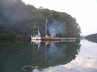
Tremayne is a hamlet in the parish of St Martin in Meneage, Cornwall, England, United Kingdom.

<span class="mw-page-title-main">Pelham Crescent, London</span>

Pelham Crescent is a circa 1825 Georgian crescent of houses in South Kensington, London SW7, England, designed by architect George Basevi. Numbers 1–14 and 15–27 are separately Grade II* listed.

<span class="mw-page-title-main">Harrington Gardens</span> Street in the Royal Borough of Kensington & Chelsea, London.

Harrington Gardens is a street which has a communal garden regionally sometimes known as a garden square in the Royal Borough of Kensington and Chelsea in London. The street runs from Collingham Gardens and Collingham Road in the east to Gloucester Road and Stanhope Gardens in the west. It is crossed by Ashburn Place and joined by Colbeck Mews on its north side. It contains several listed buildings including an important group of grade II* buildings on the south side numbered 35 to 45.

<span class="mw-page-title-main">Brompton Square</span>

Brompton Square is a garden square in London's Brompton district, in the Royal Borough of Kensington and Chelsea.

<span class="mw-page-title-main">Grenville Place</span>

Grenville Place is a street in the Royal Borough of Kensington and Chelsea, London, that connects Cornwall Gardens and Launceston Place in the north with Cromwell Road in the south. It is crossed in its northern part by Cornwall Mews South, and joined on its western side by Emperor's Gate (twice). it is joined on its eastern side by Southwell Gardens.

<span class="mw-page-title-main">Milner Street</span>

Milner Street is a street in Chelsea, London, England. It runs roughly west from Cadogan Square, crossing Ovington Street, Lennox Gardens, and Clabon Mews.

<span class="mw-page-title-main">Kynance Mews</span>

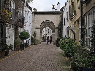
Kynance Mews is a mews street in South Kensington district of the Royal Borough of Kensington and Chelsea in London, SW7. The mews consists of 33 residential properties on a setted road that passes from Gloucester Road on the east, before being bisected by Launceston Place, with the western end of the mews ending in a cul-de-sac. The entrances to the mews pass through three arches, each listed Grade II on the National Heritage List for England. The arches were built c. 1860 to a design by Thomas Cundy III.

<span class="mw-page-title-main">Holland Park Mews</span>

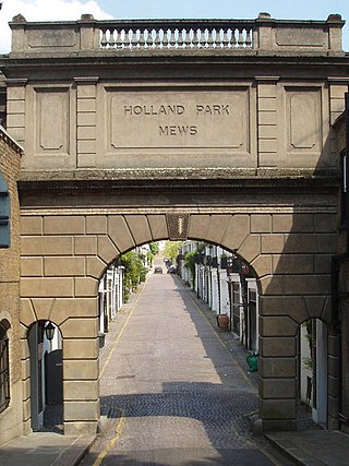
Holland Park Mews is a mews street in the Holland Park district of the Royal Borough of Kensington and Chelsea in London, W11. The mews consists of 67 residential properties, originally built as 68 stables, on a cobbled road with two entrances from Holland Park. The west entrance passes under an arch listed Grade II on the National Heritage List for England. The arch was built in 1862, and the stables from 1860 to 1879.

<span class="mw-page-title-main">Kensington New Town</span>

Kensington New Town is an area of housing in Kensington, London, which was developed in the early 19th century. It lies to the south of Kensington High Street and to the southwest of Kensington Gardens.

<span class="mw-page-title-main">Ovington Square</span>

Ovington Square is a garden square in central London's Knightsbridge district. It lies between Brompton Road to the north-west and Walton Street to the south-east.

<span class="mw-page-title-main">Mallord Street</span> Street in the Royal Borough of Kensington and Chelsea

Mallord Street is a street in London, England in the Royal Borough of Kensington and Chelsea. It was named after Joseph Mallord William Turner who had lived in Chelsea. There are no other streets named Mallord Street in Great Britain.

References

  1. 1 2 3 4 "Cornwall Gardens | British History Online". British-history.ac.uk. Retrieved 19 March 2016.
  2. Historic England, "6–16 Cornwall Gardens SW7 (1358155)", National Heritage List for England , retrieved 27 May 2018
  3. Historic England, "17–44 Cornwall Gardens SW7 (1080663)", National Heritage List for England , retrieved 27 May 2018
  4. Historic England, "55–82 Cornwall Gardens SW7 (1080664)", National Heritage List for England , retrieved 27 May 2018
  5. Historic England, "83–93 Cornwall Gardens SW7 (1080665)", National Heritage List for England , retrieved 27 May 2018
  6. Historic England, "Cornwall Gardens Garden House (1080666)", National Heritage List for England , retrieved 27 May 2018
  7. Historic England, "Pillar box adjacent to Cornwall House (1227413)", National Heritage List for England , retrieved 5 June 2018
  8. Barbara Rosen; Wolfgang Zuckermann (1982). The mews of London: a guide to the hidden byways of London's past. Webb & Bower. p. 76. ISBN   978-0-906671-50-4.
  9. "Cornwall Gardens, Kensington, London". Notable Abodes. Retrieved 19 March 2016.
  10. Hilary Spurling (2016). The Girl from the Fiction Department: A Portrait of Sonia Orwell. Penguin Books Limited. pp. 90–91. ISBN   978-0-241-97461-2.
  11. 1 2 Andrew Duncan (August 2006). Andrew Duncan's Favourite London Walks. New Holland Publishers. p. 41. ISBN   978-1-84537-454-9.
  12. Royds, Clement Molyneux (1910). The Pedigree of the Family of Royds. London: Mitchell, Hughes and Clarke. p.  53 . Retrieved 10 September 2019.
  13. "The Late Abraham Lincoln". The Daily News. London. 8 March 1890. p. 5, col. 6.

Coordinates: 51°29′48″N0°11′07″W / 51.4966°N 0.1853°W / 51.4966; -0.1853