Kynance Mews

Last updated

Kynance Mews
Looking east to the arches of Kynance Mews-geograph-3297217-by-Roger-Jones.jpg
The two arches on Launceston Place from the western end of Kynance Mews
Built1862–1879;144 years ago (1879)
Architect Thomas Cundy III
Listed Building – Grade II
Official nameEntrance arch from Gloucester Road
Designated6 August 1973 [1]
Reference no.1266548
Listed Building – Grade II
Official nameEast entrance arch from Launceston Place
Designated6 August 1973 [2]
Reference no.1225050
Listed Building – Grade II
Official nameWest entrance arch from Launceston Place
Designated6 August 1973 [3]
Reference no.1225051
Greater London UK location map 2.svg
Red pog.svg
Location of Kynance Mews in Greater London

Kynance Mews is a mews street in South Kensington district of the Royal Borough of Kensington and Chelsea in London, SW7. The mews consists of 33 residential properties on a setted road that passes from Gloucester Road on the east, before being bisected by Launceston Place, with the western end of the mews ending in a cul-de-sac. The entrances to the mews pass through three arches, each listed Grade II on the National Heritage List for England. The arches were built c. 1860 to a design by Thomas Cundy III. [1] [2] [3]

Contents

David Tucker in his 2009 book London Walks: London Stories wrote that Kensington is home to the "prettiest and most unusual" mews, and that Kynance Mews was the mews for those who want "sheer rustic rose-petal-perfect-pretty". [4] In their 1982 book The Mews of London, Barbara Rosen and Wolfgang Zuckermann wrote that upon entering the western end of the mews from Launceston Place, "one can easily forget London and imagine oneself in a village deep in the English countryside". [5] The mews is a popular place for Instagram photographs; having been described as "Insta-famous" and has been listed as one of the most "instagrammable" places to photograph wisteria in London by the Evening Standard . [6] [7]

Location

Kynance Mews is located in London's Kensington district, bisected by Launceston Place. [8] The Gloucester Road adjoins the east end of the east part of the mews. Part of the north wall of the western end backs onto the grounds of Christ Church on the corner of Victoria and Eldon Road, the church is accessible through a set of steps in the west end of the mews. [9] [10] The mews is part of the De Vere Conservation Area. [8]

History

It was known as Cornwall Mews until 1924, having been built as stabling for the Cornwall Gardens development to the south by the builders Welchman and Gale between 1862 and 1879. The mews served as the stabling for Welchman and Gale's Cornwall Gardens development. [5] [11] The houses are two or three storeys in height. [8]

Bruce Chatwin lived at No. 9 for a year from April 1969, and later shared the property with the antiques expert Oliver Hoare. [12]

The freehold of a property "requiring modernisation" on Kynance Mews was listed for sale for £9,000 in 1969 (equivalent to £157,591in 2021), with the rental price of a house listed at £40 per week in 1971. [13] [14] By August 1991 the freehold of the "largest house at the prettiest end of the mews" was listed at £325,000 (equivalent to £742,282in 2021). [15] The average price of a house on the mews was £2.3 million in 2018. [16]

Filming location

Kynance Mews Kynance Mews, W8 - geograph.org.uk - 1587867.jpg
Kynance Mews

Several films have been shot on location on Kynance Mews. [17] Bell Cottage, No. 13, is the home of Julie Andrews's character in Star! (1968), and a bus picks people up from the mews in a late scene in the film. [17] The hostage taking in the 1982 film Who Dares Wins occurs at No. 25. [17] Pamela Stephenson lives at No. 23 in 1984's Scandalous and Susan George cycles from No. 21 during the opening credits of the 1969 film Twinky . [17] Janet Suzman runs down the mews in the 1974 film The Black Windmill , and Robert Mitchum and Derek Deadman emerge from the western end of the mews in 1978's The Big Sleep . [17]

On the eastern side of the mews from Launceston Place, No 4. was home to Leslie Phillips and Julie Christie in Crooks Anonymous (1962), although the night scenes were filmed in a studio recreation of the mews. [17] No. 10 was the home of Juliette Binoche's character in the 1992 film Damage . [17]

The Mews is home to protagonist Joe in You (season 4). [18]

Related Research Articles

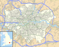
Earl's Court is a district of Kensington in the Royal Borough of Kensington and Chelsea in West London, bordering the rail tracks of the West London line and District line that separate it from the ancient borough of Fulham to the west, the sub-districts of South Kensington to the east, Chelsea to the south and Kensington to the northeast. It lent its name to the now defunct eponymous pleasure grounds opened in 1887 followed by the pre–World War II Earls Court Exhibition Centre, as one of the country's largest indoor arenas and a popular concert venue, until its closure in 2014.

South Kensington is a district just west of Central London in the Royal Borough of Kensington and Chelsea. Historically it settled on part of the scattered Middlesex village of Brompton. Its name was supplanted with the advent of the railways in the late 19th century and the opening and naming of local tube stations. The area has many museums and cultural landmarks with a high number of visitors, such as the Natural History Museum, the Science Museum and the Victoria and Albert Museum. Adjacent affluent centres such as Knightsbridge, Chelsea and Kensington, have been considered as some of the most exclusive real estate in the world.
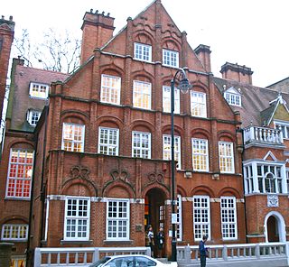
<span class="mw-page-title-main">Gloucester Road, London</span>

Gloucester Road is a street in the Royal Borough of Kensington and Chelsea, London. It runs north–south between Kensington Gardens and Old Brompton Road.

Brompton, sometimes called Old Brompton, survives in name as a ward in the Royal Borough of Kensington and Chelsea in London. Until the latter half of the 19th century it was a scattered village made up mostly of market gardens in the county of Middlesex. It lay south-east of the village of Kensington, abutting the parish of St Margaret's, Westminster at the hamlet of Knightsbridge to the north-east, with Little Chelsea to the south. It was bisected by the Fulham Turnpike, the main road westward out of London to the ancient parish of Fulham and on to Putney and Surrey. It saw its first parish church, Holy Trinity Brompton, only in 1829. Today the village has been comprehensively eclipsed by segmentation due principally to railway development culminating in London Underground lines, and its imposition of station names, including Knightsbridge, South Kensington and Gloucester Road as the names of stops during accelerated urbanisation, but lacking any cogent reference to local history and usage or distinctions from neighbouring settlements.

Thomas Cundy III was a British architect. He joined his father's practice in the 1840s and was also surveyor of the Grosvenor Estate, London. He retired from that post in 1890, and was succeeded by Eustace Balfour.

<span class="mw-page-title-main">Onslow Square</span>

Onslow Square is a garden square in South Kensington, London, England.

<span class="mw-page-title-main">St Stephen's, Gloucester Road</span> Church in London, England

St Stephen's Church, Gloucester Road, is a Grade II* listed Anglican church located on the corner of Gloucester Road and Southwell Gardens in South Kensington, London, England.

<span class="mw-page-title-main">Pelham Crescent, London</span>

Pelham Crescent is a circa 1825 Georgian crescent of houses in South Kensington, London SW7, England, designed by architect George Basevi. Numbers 1–14 and 15–27 are separately Grade II* listed.

<span class="mw-page-title-main">Devonshire Close</span> Street in London

Devonshire Close, originally known as Devonshire Mews East, is a mews street in the City of Westminster, London, accessed from Devonshire Street. The Close is on a distinctive H plan with a middle downwards leg. It dates from the 1770s and originally contained a timber yard, stables, and accommodation for domestic servants who worked in the larger houses surrounding it. Access was limited to the north side in order to divert traffic from the grander north–south streets around it. The Close was gentrified in the 20th century and its buildings converted to mews houses which, like other mews in London, have become desirable in the modern era because they are quiet and have little traffic. The Close is now part of the Howard de Walden Estate.

<span class="mw-page-title-main">The Montcalm Hotel</span> Building

The Montcalm Hotels are a group of luxury hotels in Central London, England.

<span class="mw-page-title-main">Cornwall Gardens</span>

Cornwall Gardens is a long narrow garden square in South Kensington, London, England.

<span class="mw-page-title-main">Victoria Grove, Kensington</span>

Victoria Grove is a street in Kensington, London W8. House building began in 1837 and was completed in 1841.

<span class="mw-page-title-main">Gloucester Arms, Kensington</span> Pub in Kensington, London

The Gloucester Arms is a Grade II listed pub at 34 Gloucester Road, Kensington, London SW7, built in the 19th century. It is owned by Greene King.

<span class="mw-page-title-main">56–58 Queen's Gate Terrace</span> Grade II listed building in the Royal Borough of Kensington and Chelsea

56–58 Queen's Gate Terrace is a pair of Grade II listed houses in Queen's Gate Terrace, Kensington, London SW7, built in 1863–65 by the architect Charles Gray.

<span class="mw-page-title-main">Harrington Gardens</span> Street in the Royal Borough of Kensington & Chelsea, London.

Harrington Gardens is a street which has a communal garden regionally sometimes known as a garden square in the Royal Borough of Kensington and Chelsea in London. The street runs from Collingham Gardens and Collingham Road in the east to Gloucester Road and Stanhope Gardens in the west. It is crossed by Ashburn Place and joined by Colbeck Mews on its north side. It contains several listed buildings including an important group of grade II* buildings on the south side numbered 35 to 45.

<span class="mw-page-title-main">Grenville Place</span>

Grenville Place is a street in the Royal Borough of Kensington and Chelsea, London, that connects Cornwall Gardens and Launceston Place in the north with Cromwell Road in the south. It is crossed in its northern part by Cornwall Mews South, and joined on its western side by Emperor's Gate (twice). it is joined on its eastern side by Southwell Gardens.

<span class="mw-page-title-main">Holland Park Mews</span>

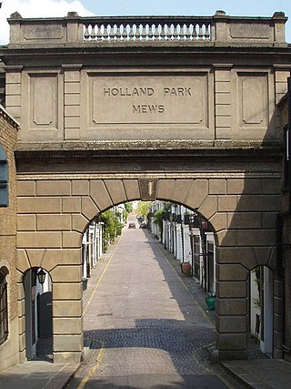
Holland Park Mews is a mews street in the Holland Park district of the Royal Borough of Kensington and Chelsea in London, W11. The mews consists of 67 residential properties, originally built as 68 stables, on a cobbled road with two entrances from Holland Park. The west entrance passes under an arch listed Grade II on the National Heritage List for England. The arch was built in 1862, and the stables from 1860 to 1879.

<span class="mw-page-title-main">Kensington New Town</span>

Kensington New Town is an area of housing in Kensington, London, which was developed in the early 19th century. It lies to the south of Kensington High Street and to the southwest of Kensington Gardens.

<span class="mw-page-title-main">Hesper Mews</span> Street in London, England

Hesper Mews is a mews street in the Earl's Court district of London, England. It runs between Bramham Gardens and Collingham Gardens and was laid-out in 1884-85 as part of the Gunter Estate, developed in the nineteenth century by James Gunter and his descendants.

<span class="mw-page-title-main">Sussex Square, London</span> Garden square in Central London

Sussex Square is a garden square in Paddington in Central London. Located in the City of Westminster, it is part of the Tyburnia area north of Hyde Park. Stanhope Terrace runs along its southern side.

References

  1. 1 2 Historic England, "Entrance arch from Gloucester Road (1266548)", National Heritage List for England , retrieved 27 May 2018
  2. 1 2 Historic England, "East entrance arch from Launceston Place (1225050)", National Heritage List for England , retrieved 27 May 2018
  3. 1 2 Historic England, "West entrance arch from Launceston Place (1225051)", National Heritage List for England , retrieved 27 May 2018
  4. David Tucker (5 February 2009). London Walks: London Stories. Ebury Publishing. p. 221. ISBN   978-0-7535-2009-3.
  5. 1 2 Barbara Rosen; Wolfgang Zuckermann (1982). The mews of London: a guide to the hidden byways of London's past. Webb & Bower. p. 76. ISBN   978-0-906671-50-4.
  6. Luke Abrahams (13 December 2017). "Meet the influencer: Sara Santini of Pretty Little London shares the best spots to Instagram in the city". The Evening Standard . Retrieved 27 May 2018.
  7. Luke Abrahams (26 March 2018). "The most Instagrammable places to see flowers in London". The Evening Standard . Retrieved 27 May 2018.
  8. 1 2 3 "Kynance Mews". Everchanging Mews. Retrieved 27 May 2018.
  9. "How to find us". Christ Church Kensington. Retrieved 27 May 2018.
  10. "Kynance Mews: Meandering the Mews of London". Solo Sophie. Retrieved 27 May 2018.
  11. British History Online: Survey of London: Volume 42, Kensington Square To Earl's Court: Cornwall Gardens| British History Online, accessdate: May 28, 2018
  12. Nicholas Shakespeare (30 September 2010). Bruce Chatwin. Random House. p. 221. ISBN   978-1-4070-7433-7.
  13. "Property" . The Times . No. 57590. 19 June 1969. p. 14. Retrieved 27 May 2018 via The Times Digital Archive.
  14. "Women's Appointments" . The Times . No. 58284. 28 September 1971. p. 25. Retrieved 27 May 2018 via The Times Digital Archive.
  15. "North of the Thames" . The Times . No. 64098. 14 August 1991. p. 26. Retrieved 27 May 2018 via The Times Digital Archive.
  16. "House prices in Kynance Mews, London SW7". Zoopla . Retrieved 27 May 2018.
  17. 1 2 3 4 5 6 7 Simon James (30 August 2007). London Film Location Guide. Pavilion Books. p. 115. ISBN   978-0-7134-9062-6.
  18. Emily, Olivia (13 February 2023). "You Season 4: All The London Filming Locations Seen On Screen". Country and Town House.

51°29′50.51″N0°11′8.23″W / 51.4973639°N 0.1856194°W / 51.4973639; -0.1856194