Cosdon Hill, also called Cosdon Beacon, or Cawsand Beacon, is one of the highest hills on Dartmoor, in Devon, England. It has numerous traces of prehistoric occupation.
Cosdon[a] is a large, rounded hill that rises to 550 metres (1,800ft). The first written record of the hill is to the Hoga de Cossdonne in 1240. The name Cossdonne seems to mean "Cost(a)'s hill", where "Cost" or "Costa" is the name of a person.
The shape of the hill gives a false impression of size, and for many years Cosdon was thought to be the highest on Dartmoor.[2] The surveyors of the Principal Triangulation of Great Britain took bearings that resulted in the first Ordnance Survey map of Dartmoor in 1809, which showed that Yes Tor was higher.[3] However, in 1830 Samuel Rowe still wrote that Cawson or Cosdon hill was the highest in Dartmoor.[4] An 1894 guide for cyclists going from Exeter to Launceston said, "So vast is the bulk of Cosdon that, were is not for the cloud mists that so often drift round his brow, one would hardly at first sight credit his height of 1799 feet."
From the summit of Cosdon it is often possible to see the English Channel from Teignmouth to Start Point, and on a clear day the Bristol Channel may be visible. The hill provides an excellent view over Dartmoor. As Thomas Clifton Paris wrote in 1865, "Far and wide stretch its desolate hills, the ancient haunt of wolves and wild deer, and barbarians as untamed; a solitary wondrous region, everywhere darkened by morasses, but piled with fantastic rocks and glowing with innumerable tints."[5]
History
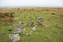
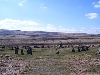
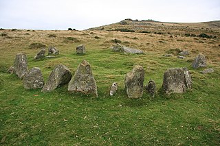
Triple stone row on North Tawton Common
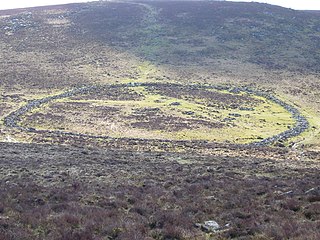
A Neolithic flint axe has been found at the western foot of the hill. There were nine Bronze Age settlements around the western edge of the hill and two associated reaves, or stone walls, that may have marked the boundaries between territories. There are also many stone cairns, kistvaens, stone rows and what may be a stone circle. Some of these have been badly damaged by stones being removed later for other uses. There is a very large cairn on the summit, which may well have been the site of a beacon.[2]
An 1896 report described three parallel lines of stones, starting from a cairn surrounded by a circle, on the North Tawton Common on the east side of Cosdon. The report noted that a wall was being built around a large slice of the common, and masons had been working for several years breaking up and removing stones for the wall. There were signs that an inner circle was buried in the cairn.[6] Two kistvaens were found within the cairn. One was intact but the coverer and two side stones had been taken from the other.[7]
Dartmoor was called a forest in 1238. It was granted by Henry III of England to his brother, Richard, Earl of Cornwall and Poictou, in 1248. The extent of the Forest of Dartmoor was verified by the solemn oath of twelve Perambulators.[8] The commissioners began their perambulation at Cosdon Hill in the north quarter of Dartmoor, then followed a circuit of the moor, returning to the starting point at Cosdon.[9] Samuel Rowe (1793–1853), Vicar of Crediton, noted in 1848 that they started at a point near the foot of the hill called Hoga de Cosdowne, and said this must have been near the banks of the Taw close to Sticklepath.[10] Arthur B. Prowse wrote in 1892 that the starting point must have simply been the summit of the hill.[11]
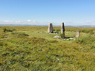
In the 1840s an adit was driven into the hill, and lodes of mispickel and copper ore were found. The shaft of the Ivy Tor Copper mine was sunk in 1851, and the mine continued to be worked for several years.[2] By 1867 Ivy Tor had been united with Copper Hill to form Belstone Consoles, on the river Tavy. The mispickel at Ivy Tor contained bismuth.[12]Actinolite and feldspar were also found at Ivy Tor.[13] For some time the hill was a shooting moor for grouse and occasional deer. Some granite shooting butts can still be seen on the north and east of the hill. There is a trig point, Flush Bracket Number S5362, on the summit of the hill, from which a wide area of country can be viewed.[2]
Baring-Gould, S.; Burnard, Robert; Rowe, J. Brooking; Pode, J. Duke; Worth, R. Hansford (July 1896), "Third Report of the Dartmoor Exploration Committee", Report & Transactions of the Devonshire Association, vol.28, retrieved 25 August 2016
Ormerod, G. Wareing (1867), "Notes on the Carboniferous Beds Adjoining the Northern Edge of the Granite of Dartmoor", Report & Transactions, retrieved 25 August 2016
Prowse, Arthur B. (1892), "The Bounds of the Forest of Dartmoor", Report & Transactions, Devonshire Association for the Advancement of Science, Literature and Art, retrieved 24 August 2016
Childe's Tomb is a granite cross on Dartmoor, Devon, England. Although not in its original form, it is more elaborate than most of the crosses on Dartmoor, being raised upon a constructed base, and it is known that a kistvaen is underneath.
Dartmoor is an upland area in southern Devon, South West England. The moorland and surrounding land has been protected by National Park status since 1951. Dartmoor National Park covers 954 km2 (368 sq mi).
High Willhays, or according to some authorities High Willes, is the highest point on Dartmoor, Devon, at 621 metres above sea level, and the highest point in Southern England.
Grimspound is a late Bronze Age settlement, situated on Dartmoor in Devon, England. It consists of a set of 24 hut circles surrounded by a low stone wall. The name was first recorded by the Reverend Richard Polwhele in 1797; it was probably derived from the Anglo-Saxon god of war, Grim.
Bowerman's Nose is a stack of weathered granite on Dartmoor, Devon, England. It is situated on the northern slopes of Hayne Down, about a mile from Hound Tor and close to the village of Manaton at grid reference SX742805. It is about 21.5 feet (6.6 m) high and is the hard granite core of a former tor, standing above a 'clitter' of the blocks that have eroded and fallen from it.
Dunkery Beacon at the summit of Dunkery Hill is the highest point on Exmoor and in Somerset, England. It is also the highest point in southern England outside of Dartmoor.
North Hessary Tor is a 517 metres hill just above Dartmoor Prison, in Princetown within Dartmoor Forest civil parish, which is in the borough of West Devon, Devon, England. The tor is one of the boundary points mentioned in the perambulations of the Forest of Dartmoor.
At 515 m, Ryder's Hill is the highest point on the southern part of Dartmoor, Devon, England. On its summit there are two standing stones and a low cairn, on top of which is a triangulation pillar.
Whiteworks is a former mining hamlet near the town of Princetown, within Dartmoor National Park, in the English county of Devon. Tin mining is central to the history of settlement at Whiteworks, which was once home to one of Dartmoor's largest tin mines. The original cottages and their inhabitants were related to this industry, until the area became used increasingly for farming in the 20th century. The site has now largely been abandoned, although Whiteworks is still on the route of many walks including Abbots Way Walk passes 500 m to the west.
Rough Tor, or Roughtor, is a tor on Bodmin Moor, Cornwall, England, United Kingdom. The site comprises the tor summit and logan stone, a neolithic tor enclosure, many Bronze Age hut circles, and some contemporary monuments.
The Dartmoor crosses are a series of stone crosses found in Dartmoor National Park in the centre of Devon, England. Many of them are old navigational aids, needed because of the remoteness of the moorland and its typically bad weather. Some mark medieval routes between abbeys. Other crosses were erected as memorials, for prayer, as town or market crosses, in churchyards, and as boundary markers. The crosses were erected over a long period of time, some as recently as 100 years ago, the earliest probably almost 1,000 years ago.
Dartmoor kistvaens are burial tombs or cists from the late Neolithic and early Bronze Age, i.e. from c. 2500 BC to c. 1500 BC. Kistvaens have been found in many places, including Dartmoor, a 954 km2 area of moorland in south Devon, England. The box-like stone tombs were created when the ancient people of the area lived in hut circles. Cists are often to be found in the centre of a cairn circle although some appear solitary which could be the result of the loss of an original slight mound. There are over 180 known cists on Dartmoor although there could be up to 100 that remain buried underneath unexplored cairns. In the South West there are no cists to be found on the Quantock Hills, only 2 to be found on Exmoor and 58 to be found on Bodmin Moor. The Dartmoor cists are unique in that about 94% have the longer axis of the tomb orientated in a NW/SE direction It appears that Dartmoor cists were positioned in such a way that the deceased were facing the Sun.
ScorhillStone Circle is now the common name for Gidleigh Stone Circle or Steep Hill Stone Circle, one of Devon's biggest and most intact stone circles, situated on Gidleigh Common near the village of Gidleigh in the north east of Dartmoor, in the United Kingdom. It is an English Heritage scheduled monument and has been described as Devon's finest stone circle.
Tor Royal is a Grade II* listed building near Princetown, Dartmoor, in the English county of Devon. Built between 1785 and 1793 by Sir Thomas Tyrwhitt, it was added to in c.1815–20, and restored by A. E. Richardson in 1912.
Samuel Rowe was a farmer's son who became a bookseller, vicar and antiquarian of Devon, England. He is known for his Perambulation of Dartmoor, which for many years was the standard work on the prehistoric and later sites to be found on the moor.
Elias Tozer was a Devon journalist, poet and collector of folk stories.
The Nine Maidens, also known as the Seventeen Brothers, is a Bronze Age stone circle located near the village of Belstone on Dartmoor in Devon, England. The stone circle functioned as a burial chamber, although the cairn has since been robbed and the cist, known locally as a kistvaen, destroyed.
Joshua Brooking Rowe was an English antiquarian and naturalist, researching and writing about history and wildlife in Devon.
The Lustleigh Cleave is a steep sided valley above the River Bovey in the parish of Lustleigh on Dartmoor. The cleave has been noted for its beauty since the 1800s, and features extensively in guidebooks.
This page is based on this Wikipedia article Text is available under the CC BY-SA 4.0 license; additional terms may apply. Images, videos and audio are available under their respective licenses.