Court House, East Quantoxhead

Last updated

Court House, East Quantoxhead
Court House, East Quantoxhead.jpg
Location East Quantoxhead, Somerset, England
Coordinates 51°11′10″N3°14′18″W / 51.18611°N 3.23833°W / 51.18611; -3.23833 Coordinates: 51°11′10″N3°14′18″W / 51.18611°N 3.23833°W / 51.18611; -3.23833
Built17th century
Listed Building – Grade I
Official nameCourt House
Designated22 May 1969 [1]
Reference no.1057409
Somerset UK location map.svg
Red pog.svg
Location of Court House, East Quantoxhead in Somerset

The Court House in East Quantoxhead, Somerset, England has a medieval tower and other parts of the building which date from the 17th century. It has been designated as a Grade I listed building. [2]

Contents

The manor has been held by the Luttrell family, who also owned Dunster Castle, since they acquired it around 1070. Only a tower survives from the medieval manor house which was built around 1400 to replace the one constructed in 1273. Most of the current building was added in the 1620s by George Luttrell and his wife Silvestra Capps. It was then used as a farmhouse until the 20th century when the latest descendants of the Luttrell line lived in it again.

The house includes a hall and gallery with a large kitchen area. The interior of the house is noted for plasterwork friezes. Surrounding the house are gardens of 5 acres (2.0 ha) with 3 acres (1.2 ha) of woodland.

History

It has been owned by the Luttrell family, who also owned Dunster Castle, for many generations since they acquired it around 1070. [3] [4]

The original manor house was constructed around 1273, adjacent to the Church of St Mary. [5] The only remaining section of the medieval house is the four-storey tower with battlements which was dated in a survey during 2003 by Historic England as coming from the late 14th or early 15th century. [6] The rest of the current building was constructed in the 17th century. [7]

By the time George Luttrell inherited Dunster castle in 1571, it was dilapidated, with the family preferring to live at Court House. [8] In the 1620s George Luttrell's first wife and mother of his twelve children died. He remarried to Silvestra Capps who persuaded him to expand the existing building with the addition of the south west wing and new porch. The expansion and improvements which left the house largely in the form it exists today were completed by 1628. [4] [9] After Capps death in 1655 the house was leased as a farmhouse, and although some minor damage was done during the next few hundred years when it was used as a granary the only structural alteration was the addition of a door at wagon level to enable loading and unloading. [4] In the 1860s quarter sessions were held at the house and it has been known as Court House ever since. [7]

In the 20th century the house was returned to residential use and occupied by Lieutenant colonel G.W. Luttrell and his wife. [4] The building was refurbished with masonry repairs and lead re-roofing in 2011 and 2012. [10]

Architecture

The front of the house The Court House, East Quantoxhead (geograph 2042601).jpg
The front of the house

The two-storey house is laid out around a courtyard. [1] The front of the building is Jacobean with the main entry being the two storey porch. The main hall has a gallery above reached via a Tudor oak staircase. The kitchen includes two fireplaces one of which is 12 feet 6 inches (3.81 m) wide and could be used to roast a whole cow. The outer kitchen was used for cider making and contained a large apple press. A small room off the kitchen was used as a cell for drunks awaiting sentence in the court. [4]

The base of the tower includes a court for Cockfights. and other "sporting" memorabilia in the house includes oak staves used for glatting to catch Conger eels with dogs on the nearby beach at Kilve. [4] [11]

The interior of the house is noted for plasterwork friezes. In the hall the fireplace mantel, which dates from 1629, bears the Luttrell coat of arms with soldiers on either side. It was created by two Flemish workers brought in by George Luttrell. They and their descendants stayed in West Somerset and are responsible for the plasterwork in all the great houses in the area, including Court House and Dunster Castle. In most of the rooms of the house the friezes depict biblical scenes. In the drawing room is a representation of Christ with the children, the north bedroom has Christ's entry into Jerusalem, another room depicts Christ's descent from the cross. [4] The scenes are taken from a book Vita, Passio, et Resurrectio Jesu Christi published in Antwerp in 1566. [9]

Gardens

The parkland surrounding the house The Courthouse (geograph 2504879).jpg
The parkland surrounding the house

The gardens cover an area of 5 acres (2.0 ha) with 3 acres (1.2 ha) of woodland. The current gardens were laid out in the 1950s, using acidic soil to create a Cornish garden with camellias, rhododendrons, magnolias and pale-flowered hydrangeas, herbaceous borders and a traditional kitchen garden. [12]

See also

Related Research Articles

Quantock Hills Range of hills west of Bridgwater in Somerset, England

The Quantock Hills west of Bridgwater in Somerset, England, consist of heathland, oak woodlands, ancient parklands and agricultural land. They were England's first Area of Outstanding Natural Beauty, designated in 1956.

Dunster Human settlement in England

Dunster is a village, civil parish and former manor within the English county of Somerset, today just within the north-eastern boundary of the Exmoor National Park. It lies on the Bristol Channel coast 2.5 miles (4 km) south-southeast of Minehead and 20 miles (32 km) northwest of Taunton. The United Kingdom Census of 2011 recorded a parish population of 817.

Dunster Castle Country house, owned by National Trust

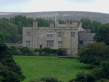
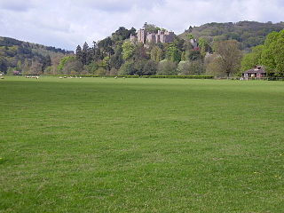
Dunster Castle is a former motte and bailey castle, now a country house, in the village of Dunster, Somerset, England. The castle lies on the top of a steep hill called the Tor, and has been fortified since the late Anglo-Saxon period. After the Norman conquest of England in the 11th century, William de Mohun constructed a timber castle on the site as part of the pacification of Somerset. A stone shell keep was built on the motte by the start of the 12th century, and the castle survived a siege during the early years of the Anarchy. At the end of the 14th century the de Mohuns sold the castle to the Luttrell family, who continued to occupy the property until the late 20th century.

Nettlecombe Court Grade I listed building in Somerset, UK

Nettlecombe Court and park is an old estate on the northern fringes of the Brendon Hills, within the Exmoor National Park. They are within the civil parish of Nettlecombe, named after the house, and are approximately 3.6 miles (5.8 km) from the village of Williton, in the English county of Somerset. It has been designated by English Heritage as a Grade I listed building.

Colonel Sir Geoffrey Walter Fownes Luttrell was an English landowner in Somerset and a soldier who distinguished himself during the Second World War.

East Quantoxhead Human settlement in England

East Quantoxhead is a village in the district of Somerset West and Taunton, 3 miles (5 km) from West Quantoxhead, 4 miles (6 km) east of Williton, and 13 miles (21 km) west of Bridgwater, within the Quantock Hills Area of Outstanding Natural Beauty in Somerset, England.

Grade I listed buildings in Somerset Buildings of exceptional interest in Somerset

The Grade I listed buildings in Somerset, England, demonstrate the history and diversity of its architecture. The ceremonial county of Somerset consists of a non-metropolitan county, administered by Somerset County Council, which is divided into five districts, and two unitary authorities. The districts of Somerset are West Somerset, South Somerset, Taunton Deane, Mendip and Sedgemoor. The two administratively independent unitary authorities, which were established on 1 April 1996 following the breakup of the county of Avon, are North Somerset and Bath and North East Somerset. These unitary authorities include areas that were once part of Somerset before the creation of Avon in 1974.

Nailsea Court Grade I listed building in Somerset, UK

Nailsea Court in Nailsea, Somerset, England, is an English manor house dating from the 15th century. Pevsner describes the house as "historically highly instructive and interesting" and it is a Grade I listed building.

Yarn Market, Dunster Grade I listed building in West Somerset, United Kingdom

The Yarn Market in Dunster, Somerset, England was built in the early 17th century. It has been designated as a Grade I listed building and scheduled monument. Dunster was an important market place in the Middle Ages particularly following the construction of Dunster Castle and the establishment of the Priory Church of St George.

Dunster Priory

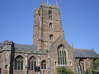
Dunster Priory was established as a Benedictine monastery around 1100 in Dunster, Somerset, England.

Barford Park

Barford Park is a Georgian country house and park to the south of Spaxton, west of Bridgwater, Somerset, England. It was designated a grade II* listed building on 29 March 1963. The name "Barford" comes from owners of the land, who had a house on the site in the 13th and 14th centuries.

Fairfield, Stogursey

Fairfield House is a historic house in Stogursey, Somerset, England. A house existed on the site from the 12th century and it has been owned by the same family since that time. The current building is largely 16th-century, but has undergone various remodellings since then. It is designated as a Grade II* listed building.

Chapel Cleeve Manor

Chapel Cleeve Manor in Chapel Cleeve, Somerset, England started life in the 1450s as a pilgrims' hostel. It was enlarged in the 19th and 20th centuries when it was a private house and then a hotel. It is a Grade II* listed building.

Henry Fownes Luttrell (died 1780) British politician and landowner

Henry Fownes Luttrell, of Dunster Castle, Somerset, was High Sheriff of Somerset from 1754 to 1755 and a Member of Parliament for the borough of Minehead from 1768 to 1774.

Alexander Luttrell (1705–1737) English politician

Alexander Luttrell of Dunster Castle, Somerset, was an English land-owner who served as Member of Parliament for his family's pocket borough of Minehead from 1727 until his death. He was the last in the male line of the Luttrell family, which had owned Dunster Castle since 1376.

Margaret Fownes-Luttrell

Margaret Fownes-Luttrell was a British heiress, the wife of Henry Fownes Luttrell. She was the heiress of Dunster Castle, under the stipulation in her father's will that her husband should take the additional surname of Luttrell. Four portraits of her exist in Dunster castle and a fifth at Bathealton Court.

Richard Phelps (artist) English painter

Richard Phelps (1710–1785) was an 18th-century English portrait painter and designer. He painted portraits of gentry, a number of which are in the National Trust, Dunster Castle, University of Oxford, National Portrait Gallery, London, and other museums. The British Museum has an album of 312 of his drawings. Phelps was also a landscape designer, who was hired by Henry Fownes Luttrell to update the grounds of Dunster Castle.

Feudal barony of Dunster

The feudal barony of Dunster was an English feudal barony with its caput at Dunster Castle in Somerset. During the reign of King Henry I (1100–1135) the barony comprised forty knight's fees and was later enlarged. In about 1150 the manors retained in demesne were Dunster, Minehead, Cutcombe, Kilton and Carhampton in Somerset, and Ham in Dorset.

Thomas Luttrell (died 1571) 16th-century English politician

Thomas Luttrell, of Dunster Castle in Somerset, feudal baron of Dunster, was a Member of Parliament for his family's newly enfranchised pocket borough of Minehead, from 1563 to 1567. He was Sheriff of Somerset in 1570–1.
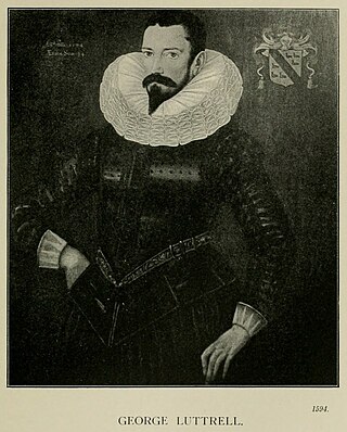
Church of St Mary, East Quantoxhead Church in Somerset, England

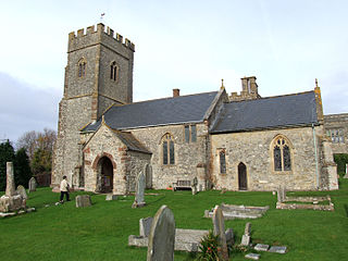
The Anglican Church of St Mary in East Quantoxhead, Somerset, England was built in the 14th century. It is a Grade II* listed building.

References

  1. 1 2 Historic England. "Court House (1057409)". National Heritage List for England . Retrieved 3 April 2015.
  2. "Court House". historicengland.org.uk. English Heritage. Retrieved 8 January 2009.
  3. "East Quantoxhead". Quantock Online. Retrieved 25 October 2014.
  4. 1 2 3 4 5 6 7 Delderfield, Eric R. (1970). West Country Historic Houses and their families: Volume 2. Dorset, Wiltshire and North Somerset. Newton Abbot: David & Charles. pp. 40–45. ISBN   978-0715349106.
  5. A P Baggs, R J E Bush and M C Siraut, 'Parishes: East Quantoxhead', in A History of the County of Somerset: Volume 5, ed. R W Dunning (London, 1985), pp. 120-129. British History Online http://www.british-history.ac.uk/vch/som/vol5/pp120-129 [accessed 7 October 2017].
  6. "Survey (2003), Court House, East Quantoxhead". Somerset Historic Environment Record. Somerset County Council. Retrieved 25 October 2014.
  7. 1 2 R.W. Dunning (editor), A.P. Baggs, R.J.E. Bush, M.C. Siraut (1985). "Parishes: East Quantoxhead". A History of the County of Somerset: Volume 5. Institute of Historical Research. Retrieved 25 October 2014.{{cite web}}: |author= has generic name (help)CS1 maint: multiple names: authors list (link)
  8. Garnett, Oliver (2003). Dunster Castle. National Trust. pp. 39–40. ISBN   978-1-84359-049-1.
  9. 1 2 Hunter, Michael Cyril William (2010). Printed Images in Early Modern Britain: Essays in Interpretation. Ashgate Publishing, Ltd. p. 66. ISBN   9780754666547.
  10. "Case Study. Court House. East Quantoxhead" (PDF). Ellis & Co. Retrieved 26 October 2014.
  11. Farr, Grahame (1954). Somerset Harbours. London: Christopher Johnson. pp. 119–120.
  12. "Court House". National Gardens Scheme. Retrieved 25 October 2014.