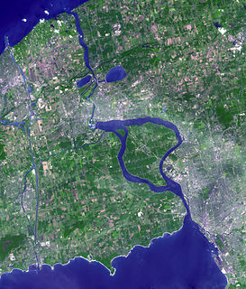
The Niagara River is a river that flows north from Lake Erie to Lake Ontario. It forms part of the border between the province of Ontario in Canada and the state of New York in the United States. There are differing theories as to the origin of the river's name. According to Iroquoian scholar Bruce Trigger, Niagara is derived from the name given to a branch of the locally residing native Neutral Confederacy, who are described as being called the Niagagarega people on several late-17th-century French maps of the area. According to George R. Stewart, it comes from the name of an Iroquois town called Ongniaahra, meaning "point of land cut in two".

The Humber River is a river in Southern Ontario, Canada. It is in the Great Lakes Basin, is a tributary of Lake Ontario and is one of two major rivers on either side of the city of Toronto, the other being the Don River to the east. It was designated a Canadian Heritage River on September 24, 1999.

Halton Hills is a town in the Regional Municipality of Halton, located in the northwestern end of the Greater Toronto Area, Ontario, Canada with a population of 61,161 (2016).

The Rouge River is a river in Markham, Pickering, Richmond Hill and Toronto in the Greater Toronto Area of Ontario, Canada. The river flows from the Oak Ridges Moraine to Lake Ontario at the eastern border of Toronto, and is the location of Rouge Park, the only national park in Canada within a municipality. At its southern end, the Rouge River is the boundary between Toronto and southwestern Pickering in the Regional Municipality of Durham.

The Nottawasaga River is a river in Simcoe County and Dufferin County in Central Ontario, Canada. It is part of the Great Lakes Basin, and is a tributary of Lake Huron. The river flows from the Orangeville Reservoir in the town of Orangeville, Dufferin County, through the Niagara Escarpment and the Minesing Wetlands, the latter a wetland of international significance, and empties into Nottawasaga Bay, an inlet of Georgian Bay on Lake Huron, at the town of Wasaga Beach, Simcoe County.
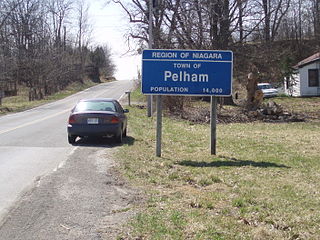
The Town of Pelham is located in the centre of Niagara Region in Ontario, Canada.

The Sauble River is a river in Bruce County and Grey County in southwestern Ontario, Canada that flows from its headwaters in the township of Chatsworth to Lake Huron at the community of Sauble Beach.
The Rankin River is a river in the town of South Bruce Peninsula, Bruce County in southwestern Ontario, Canada which flows from the east side of the Bruce Peninsula to join the Sauble River near Sauble Falls Provincial Park on the west side. The river is in the Lake Huron drainage basin and was named after Charles Rankin, who first surveyed the Bruce Peninsula.

The Welland River is a river in the Golden Horseshoe that passes through the Southern Ontario cities of Welland and Niagara Falls. It flows from its source just south of Hamilton, Ontario to meet the Niagara River.
The Maitland River is a river in Huron County, Perth County and Wellington County in Southwestern Ontario, Canada. The river is in the Great Lakes Basin and empties into Lake Huron at the town of Goderich. It is 150 kilometres (93 mi) long, and is named after Sir Peregrine Maitland, Lieutenant-Governor of Upper Canada from 1818 to 1828. It was formerly known as the Menesetung River.

King's Highway 406, commonly referred to as Highway 406, is a 400-series highway in the Canadian province of Ontario. The primary north-south route though the central portion of the Niagara Peninsula, Highway 406 connects Welland, Thorold and downtown St. Catharines to the Queen Elizabeth Way (QEW).
Lake Gibson is a lake near Thorold in the Regional Municipality of Niagara, Ontario, Canada. The lake is not natural, but rather was created as a reservoir for hydroelectric power generation at the Ontario Power Generation Decew Falls 1 and Decew Falls 2 generating stations. The lake was created by flooding the shallow valley of Beaverdams Creek. Lake Moodie is located to the northwest of Lake Gibson and is a smaller segment of the overall Lake Gibson system. Almost all of the water supply to these lakes comes from Lake Erie via the Welland Canal. The lakes suck part of the Twelve Mile Creek watershed.
St. Johns is an unincorporated rural community in Thorold, Niagara Region, Ontario, Canada.

Conservation Ontario is the umbrella organization which represents all of the conservation authorities in Ontario. This nonprofit organization was founded in 1980/81. Conservation Ontario is the network of 36 Conservation Authorities.
The Twenty Mile Creek is a minor waterway, located in the Niagara Peninsula, Ontario, Canada. The creek is named for the location of its mouth, twenty miles (32 km) west of the Niagara River along the Lake Ontario shoreline. The Indian name for the Twenty Mile Creek was the Kenachdaw, which translates to Lead River.

Twelve Mile Creek is a waterway located on the Niagara Peninsula in the Regional Municipality of Niagara in Southern Ontario, Canada. Its headwaters are located in the town of Pelham, encompassing some of the most unspoiled and natural areas of Niagara area. The creek's lower reaches flow through urban areas of Thorold and St. Catharines, and have been heavily altered by human activity for almost two centuries.

Beamer Memorial Conservation Area is located on the Niagara Escarpment in Grimsby, Ontario, Canada and is owned and operated by the Niagara Peninsula Conservation Authority. It is noted for being the best location on the Niagara Peninsula to observe the annual spring migration of raptors.
Sixteen Mile Creek is a stream in the municipalities of Lincoln, Pelham and West Lincoln, Regional Municipality of Niagara in Southern Ontario, Canada. It is part of the Great Lakes Basin and flows from the top of the Niagara Escarpment to Sixteen Mile Pond on Lake Ontario. The stream falls within the remit of the Niagara Peninsula Conservation Authority, whose 2012 watershed report card gave the stream watershed grades of D for both water quality and forest cover.
Kent Creek is a tributary of the Lynn River, one of the watersheds administered by the Long Point Region Conservation Authority. It is considered a cold-water stream, and hosts a population of Brook Trout. It drains 38.24 square kilometres (14.76 sq mi).
The Niagara Peninsula Conservation Authority is a conservation authority in the Canadian province of Ontario. It was established via the Conservation Authorities Act, and is a member authority of Conservation Ontario.
