
Tremadog is a village in the community of Porthmadog, in Gwynedd, north west Wales; about one mile (1.6 km) north of Porthmadog town centre. It was a planned settlement, founded by William Madocks, who bought the land in 1798. The centre of Tremadog was complete by 1811 and remains substantially unaltered. Tremadog hosted an unofficial National Eisteddfod event in 1872.

Bwlch is a small village and an electoral ward in the community of Cwmdu and District, Powys, south Wales. The settlement is strung out along the A40 road which crosses a low col above the Usk Valley at this point on its route between Brecon and Crickhowell.
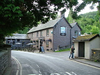
Talybont-on-Usk is a village and community in Powys, Wales, in the historic county of Brecknockshire. It lies on both the Caerfanell river and the Monmouthshire and Brecon Canal, about 1 mile (1.6 km) from the River Usk. In 2001, it had a population of 743, reducing to 719 at the 2011 census. The community includes the settlements of Llansantffraed, Scethrog, Aber Village, and Pencelli.

Nantgarw is a village in the county borough of Rhondda Cynon Taf, Wales, near Cardiff.
Allt-yr-yn is a suburb of the city of Newport, south-east Wales.
Cathedine is a small hamlet that lies between the Brecon Beacons and the Black Mountains, in Powys, Wales. It is an approximately 2 miles from Llangorse and 2 miles from Bwlch, in the community of Llangors.

Allt yr Esgair is a hill in the Brecon Beacons National Park in Powys, Wales. It is commonly referred to locally as simply 'The Allt'. The Welsh name signifies 'wooded slope of the ridge'. It takes the form of a northwest-southeast aligned ridge which rises to a height of 393m and which overlooks the valley of the River Usk to the west and south. To the northeast are panoramic views across Llangorse Lake to the Black Mountains There is a viewfinder on the summit erected as a monument to Eirene Lloyd White, Baroness White of Rhymney. It is a Marilyn with a prominence of 199 metres.
Nantgarw Colliery was a coal mine and later developed Coking coal works, located in the village on Nantgarw, Mid Glamorgan, Wales located just north of Cardiff.

Graigwen is the name of the large hill and the village or district located thereon, sited to the north of Pontypridd town centre and south of Glyncoch and Ynysybwl in the county borough of Rhondda Cynon Taf, Wales, and within the ancient parish of Llanwonno (Llanwynno). It falls within the Rhondda and Pontypridd Town electoral wards, and comprises the sub-districts of Pantygraigwen, Penygraigwen, the Whiterock Estate, and Lanwood. It is also bounded by the districts of Pwllgwaun and Hopkinstown.

Mynydd Cilfach-yr-encil attains a height of 445m at OS grid reference SO 079033 making it the high point of the broad ridge of high ground between Taff Vale and Cwm Bargod in the Valleys region of South Wales. It lies within the County Borough of Merthyr Tydfil.

Walterstone is a village and civil parish in Herefordshire, England, near the Welsh border and the Brecon Beacons National Park, 14 miles (23 km) south-west of Hereford. The parish had a population of 97 in the 2001 UK Census and is grouped with Craswall, Llanveynoe and Longtown to form Longtown Group Parish Council for administrative purposes.

Dwygyfylchi is a village in Conwy County Borough, Wales. It is part of the community of Penmaenmawr which has a population of 4,353. The electoral ward of Capelulo which includes Dwygyfylchi had a population of 1,485 in 2011. It forms part of the historic county of Caernarfonshire.

Raglan Barracks is a military installation at Barrack Hill in Allt-yr-yn in Newport, Wales.
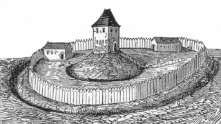
Tomen yr Allt was a Medieval motte and bailey defensive castle near Llanfyllin in Powys, Wales. "Tomen ar hallt" is modern Welsh for "mound on the wooded hillside."

Ridgeway is an area in Newport, Wales, in the electoral ward and community of Allt-yr-yn. It is well known for its ridge which overlooks Rogerstone and the nearby woodland areas. Ridgeway is at the end of the estate the main road breaks off onto the M4 motorway.
