
Interstate 195 (I-195) is an auxiliary Interstate Highway running a combined 44.55 miles (71.70 km) in the US states of Rhode Island and Massachusetts. It travels from a junction with I-95 in Providence, Rhode Island, east to a junction with I-495 and Massachusetts Route 25 in Wareham, Massachusetts. It runs east–west and passes through the cities of Fall River, Massachusetts, and New Bedford, Massachusetts. The portion of I-195 in East Providence is also known as the East Providence Expressway.

Route 10 is a numbered state highway connector in the U.S. state of Rhode Island, traveling along the Huntington Expressway, the first freeway in the state. It connects Route 12 on the Cranston–Providence city line with Interstate 95 (I-95), U.S. Route 6 (US 6), and Memorial Boulevard in downtown Providence, passing just east of the Olneyville area of Providence. It provides an alternate route to I-95 south of downtown, and connects it with the US 6 freeway west from Olneyville towards I-295 and Connecticut.

Route 114 is a 45.7-mile-long (73.5 km) numbered state highway in the U.S. state of Rhode Island. It connects the city of Newport to the city of Woonsocket. Route 114 was a major north–south artery for its entire length until the arrival of the Interstate Highway System. It is still a major commercial corridor on Aquidneck Island and in northern Rhode Island.
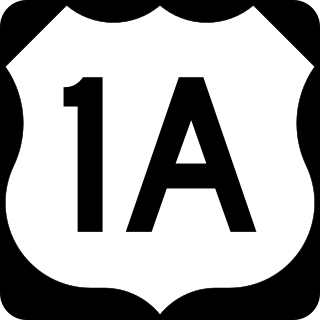
U.S. Route 1A (US 1A) is the name of several highways found in the United States.

The Henderson Bridge is a bridge in Rhode Island which spans the Seekonk River, and connects the East Side neighborhood of Providence with the Watchemoket and Phillipsdale neighborhoods of East Providence. After a major reconstruction, the bridge reopened to automobile traffic in phases from November 16 to 20, 2023. A new cycle path opened on November 27. A few weeks later, it was used as a detour during the emergency closure of the westbound half of the parallel Washington Bridge.

The East Side Railroad Tunnel is a former railroad tunnel that runs underneath the East Side of Providence, Rhode Island. The tunnel runs 5,080 feet (1,550 m), under College Hill, from Gano Street to just west of Benefit Street. It was opened on November 16, 1908, at a cost of $2 million. All rail service ceased through the tunnel in 1976 and has been abandoned since.

The Woonasquatucket River, sometimes called "the Woony", is a river in the U.S. state of Rhode Island. It flows approximately 15.8 miles (25.4 km) and drains a watershed of 130 km2 (50 sq mi).

Interstate 95 (I-95) is the main north–south Interstate Highway on the East Coast of the United States, running generally southwest–northeast through the US state of Rhode Island. It runs from the border with Connecticut near Westerly, through Warwick and Providence, and to the Massachusetts state line in Pawtucket. It has two auxiliary routes, both of which enter Massachusetts—I-195, a spur from Providence east to Cape Cod, and I-295, a western bypass of the Providence metropolitan area.

U.S. Route 6 (US 6) is a major east–west road in the U.S. state of Rhode Island. Nationally, the route continues west to Bishop, California, and east to Provincetown, Massachusetts. In western Rhode Island, it forms part of one of several routes between Hartford, Connecticut, and Providence and was planned to be replaced by Interstate 84 (I-84). The part of I-84 that was built, from I-295 to Olneyville, is now part of US 6. At Olneyville, US 6 joins Route 10 and heads east toward Downtown, Providence, where it turns south on I-95 and east on I-195. US 6 splits from I-195 in East Providence, crossing into Massachusetts on Warren Avenue. The whole route of US 6 is a state highway maintained by the Rhode Island Department of Transportation (RIDOT).

The Rhode Island city of Providence has a nearly 400-year history integral to that of the United States, including significance in the American Revolutionary War by providing leadership and fighting strength, quartering troops, and supplying goods to residents by circumventing the blockade of Newport. The city is also noted for the first bloodshed of the American Revolution in the Gaspée Affair. Additionally, Providence is notable for economic shifts, moving from trading to manufacturing. The decline of manufacturing devastated the city during the Great Depression, but the city eventually attained economic recovery through investment of public funds.

The Providence River is a tidal river in the U.S. state of Rhode Island. It flows approximately 8 miles (13 km). There are no dams along the river's length, although the Fox Point Hurricane Barrier is located south of downtown to protect the city of Providence from damaging tidal floods.

Route 152 is a state highway in the U.S. states of Rhode Island and Massachusetts. The highway begins at U.S. Route 1A and Route 114 in East Providence, Rhode Island. After crossing into Massachusetts, Route 152 runs 14.8821 miles (23.9504 km) through Seekonk, Attleboro, and North Attleboro to US 1 in Plainville.

Downtown is the central economic, political, and cultural district of the city of Providence, Rhode Island, United States. It is bounded on the east by Canal Street and the Providence River, to the north by Smith Street, to the west by Interstate 95, and to the south by Henderson Street. The highway serves as a physical barrier between the city's commercial core and neighborhoods of Federal Hill, West End, and Upper South Providence. Most of the downtown is listed on the National Register of Historic Places as the Downtown Providence Historic District.
The Jewelry District is a neighborhood of Providence, Rhode Island located just southeast of Downtown. The historical path of Interstate 195 delineates the neighborhood's northern border while Interstate 95 and the Providence River define its western, southern and eastern edges.
Albion is a village and historic district in Lincoln, Rhode Island, United States.

Providence is the capital and most populous city of the U.S. state of Rhode Island. The county seat of Providence County, it is one of the oldest cities in New England, founded in 1636 by Roger Williams, a Reformed Baptist theologian and religious exile from the Massachusetts Bay Colony. He named the area in honor of "God's merciful Providence" which he believed was responsible for revealing such a haven for him and his followers. The city developed as a busy port, as it is situated at the mouth of the Providence River at the head of Narragansett Bay.

The Providence, Warren and Bristol Railroad was a railroad in the state of Rhode Island that connected the city of Providence with Bristol, Rhode Island. The company was formed in 1854 by merging the Providence, Warren and Bristol Railroad Companies of Massachusetts and Rhode Island. The 14.1-mile line itself was completed on July 12, 1855.

The Providence Viaduct refers to the two 4-lane bridges in each direction of Interstate 95 (I-95) that passes through downtown Providence, Rhode Island, in the United States. The structure passes over the Woonasquatucket River and Amtrak lines. It also connects with Interstate 195, U.S. Route 6 (US 6), and Route 146. The bridge was built in 1964 and rehabilitated in 1992.
The following is a timeline of the history of the city of Providence, Rhode Island, United States.

The Michael S. Van Leesten Memorial Bridge is a footbridge crossing the Providence River located in the city of Providence, Rhode Island. The bridge connects Providence's Fox Point neighborhood to the city's Jewelry District. Originally known as the Providence River Pedestrian Bridge, in July 2020 it was renamed in honor of Michael S. Van Leesten.


