Crayne, Kentucky | |
|---|---|
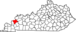
 Crayne Location within the state of Kentucky  Crayne Crayne (the United States) | |
| Coordinates: 37°16′14″N88°4′57″W / 37.27056°N 88.08250°W | |
| Country | United States |
| State | Kentucky |
| County | Crittenden |
| Area | |
• Total | 1.12 sq mi (2.90 km2) |
| • Land | 1.11 sq mi (2.89 km2) |
| • Water | 0.01 sq mi (0.01 km2) |
| Elevation | 640 ft (200 m) |
| Population (2020) | |
• Total | 161 |
| • Density | 144.39/sq mi (55.75/km2) |
| Time zone | UTC-6 (Central (CST)) |
| • Summer (DST) | UTC-5 (CDT) |
| ZIP codes | 42033 |
| FIPS code | 21-18190 |
| GNIS feature ID | 490310 [2] |
Crayne is a census-designated place and unincorporated community within Crittenden County, Kentucky, United States. As of the 2010 census it had a population of 173. [3]