The Rhinogydd are a range of mountains located east of Harlech in North Wales. The name Rhinogydd derives from the names of two of the more famous peaks, Rhinog Fawr and Rhinog Fach, although the greatest elevation in the range is reached by Y Llethr, 756 m.

Pen y Fan is the highest peak in south Wales, situated in the Brecon Beacons National Park. At 886 metres (2,907 ft) above sea-level, it is also the highest British peak south of Cadair Idris in Snowdonia. The twin summits of Pen y Fan and Corn Du at 873 m were formerly referred to as Cadair Arthur or 'Arthur's Seat'.

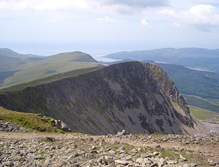
Aran Fawddwy is a mountain in southern Snowdonia, Wales, United Kingdom. It is the only peak in Wales outside North Snowdonia above 900m, and higher than anywhere in Great Britain outside Northern Snowdonia, the Scottish Highlands and the Lake District. The nearest urban centres to the mountain are Dinas Mawddwy to the south, Llanymawddwy to the southeast, Llanuwchllyn on the shores of Bala Lake to the north, and Rhydymain to the west. The nearest settlements with around 2,000 people are Bala and Dolgellau. On the eastern slopes of Aran Fawddwy is the small lake named Creiglyn Dyfi, the source of the River Dyfi. Its sister peak is Aran Benllyn at 885 metres (2,904 ft). There is also a middle peak- Erw y Ddafad-ddu.

Cadair Idris or Cader Idris is a mountain in Gwynedd, Wales, which lies at the southern end of the Snowdonia National Park near the town of Dolgellau. The peak, which is one of the most popular in Wales for walkers and hikers, is composed largely of Ordovician igneous rocks, with classic glacial erosion features such as cwms, moraines, striated rocks, and roches moutonnées.

Arenig Fawr is a mountain in Snowdonia, North Wales, close to Llyn Celyn reservoir, alongside the A4212 between Trawsfynydd and Bala.

Rhobell Fawr is an extinct volcano in the Arenig range within the Snowdonia National Park.

Maesglase is a mountain in Snowdonia, North Wales, situated approximately four miles to the south-west of Aran Fawddwy. It is the highest of the "Dyfi Hills".

Aran Benllyn is a subsidiary summit of Aran Fawddwy in southern Snowdonia, North Wales, Wales, United Kingdom. It is the second highest peak in the Aran mountain range.
Craig Cwm Amarch is not synonymous with Craig y Cau but names the headwall of Cwm Amarch on Cadair Idris in the Snowdonia National Park, in Gwynedd, north-west Wales.

Gau Graig is a subsidiary summit of Cadair Idris in the Snowdonia National Park, in Gwynedd, northwest Wales. It lies to the east of Mynydd Moel on a broad grassy plateau. It marks the eastern end of the Cadair Idris ridge.
Cyfrwy is a subsidiary summit of Cadair Idris in the Snowdonia National Park, in Gwynedd, northwest Wales. It lies to the west of Cadair Idris and is often climbed with Cadair Idris by taking the Pony Path.

Glasgwm is a mountain in Gwynedd, Wales forming part of the Aran range in southern Snowdonia. It is one of the three Marilyns that make up the range, the others being Aran Fawddwy and Esgeiriau Gwynion. To the west is Maesglase and the Dyfi hills, while to the south-west lies Cadair Idris. To the south lies the Plynlimon range. It is 779 metres (2,556 ft) high.

Waun-oer is a mountain in Snowdonia, North Wales, situated approximately four miles to the south-west of Aran Fawddwy. It is one of the peaks in the Dyfi hills, a subgroup of the Cadair Idris group. It is a top of Maesglase and the summit consists of a trig point that crowns an uneven grassy plateau. It is connected to Cribin Fawr to the east. To the north lies Cadair Idris, while Tarren y Gesail lies to the west.

Tarren y Gesail is a mountain in Snowdonia, North Wales. It is one of the Marilyns of the Cadair Idris group.

Tarrenhendre is a mountain in Snowdonia, North Wales. It is one of the Marilyns in the Cadair Idris group.

Pen y Brynfforchog is subsidiary summit of Glasgwm in North Wales forming part of the Aran range in southern Snowdonia.

Moel Emoel is a hill within the Snowdonia National Park in Gwynedd, North Wales.

The Dyfi hills are a range situated in the southernmost area of Snowdonia, bounded by the River Dyfi on the east and south sides, by the Afon Dulas on the west and the Afon Cerist to the north. They lie to the West of the Aran Fawddwy range, north-east of the Tarren y Gesail range and are a subgroup of the Cadair Idris group.

Pen Ty-Nant is a hill within the Snowdonia National Park in Gwynedd, North Wales.