The historic City of Cripple Creek is the Statutory City that is the county seat of Teller County, Colorado, United States. The city population was 1,155 at the 2020 United States Census. Cripple Creek is a former gold mining camp located 20 miles (32 km) southwest of Colorado Springs near the base of Pikes Peak. The Cripple Creek Historic District, which received National Historic Landmark status in 1961, includes part or all of the city and the surrounding area. The city is now a part of the Colorado Springs, CO Metropolitan Statistical Area and the Front Range Urban Corridor.
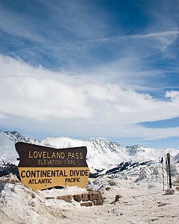
Loveland Pass is a high mountain pass in north-central Colorado, at an elevation of 11,990 feet (3,655 m) above sea level in the Rocky Mountains of the Western United States.

St. Vrain Creek is a tributary of the South Platte River, approximately 32.2 miles (51.8 km) long, in north central Colorado in the United States. It drains part of the foothills north of Boulder and the Colorado Piedmont area in the vicinity of Longmont.
Hoosier Pass is a high mountain pass in central Colorado, in the Rocky Mountains of the western United States. The name derives from Indiana, nicknamed the "Hoosier State," which was the original home of many pioneers.
Wild Horse Creek is a stream in the U.S. state of Colorado.

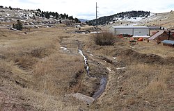
Goldfield is an unincorporated community and a census-designated place (CDP) located in and governed by Teller County, Colorado, United States. The CDP is a part of the Colorado Springs, CO Metropolitan Statistical Area. The population of the Goldfield CDP was 49 at the United States Census 2010. The Cripple Creek post office (Zip Code 80813) serves the area.
Stoner Creek is a stream in Dolores County, Colorado, in the United States.
Howard Creek is a stream in the U.S. state of Colorado.
Alder Creek is a stream entirely within Saguache County, Colorado.
Caddoa Creek is a stream in the U.S. state of Colorado.

Cebolla Creek is a stream in the U.S. state of Colorado, and is a tributary of the Gunnison River.
Deception Creek is a stream in the U.S. state of Colorado.

Dove Creek is a stream in the U.S. state of Colorado.
Granada Creek is a stream in the U.S. state of Colorado.

Leopard Creek is a stream located entirely within San Miguel County, Colorado.
Lay Creek is a stream in the U.S. state of Colorado.

Rifle Creek is a stream in Garfield County in the U.S. state of Colorado. Rifle Creek is a tributary to the Colorado River.

Timpas Creek is a stream in the U.S. state of Colorado.
Troublesome Creek is a stream in the U.S. state of Colorado. It is a tributary of the Colorado River.
Tungsten is a ghost town in Boulder County, in the U.S. state of Colorado. The former townsite is north of Middle Boulder Creek.