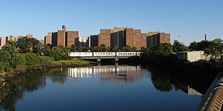
Coney Island Creek is a 1.8-mile-long (2.9 km) tidal inlet in Brooklyn, New York City. It was created from a series of streams and inlets by land filling and digging activities starting in the mid-18th century which, by the 19th century, became a 3-mile-long (4.8 km) continual strait and a partial mudflat connecting Gravesend Bay and Sheepshead Bay, separating Coney Island from the mainland. The strait was closed off in the early 20th century due to further land development and later construction projects. Today only the western half of Coney Island Creek exists.

The Belt Parkway is the name given to a series of controlled-access parkways that form a belt-like circle around the New York City boroughs of Brooklyn and Queens. The Belt Parkway comprises three of the four parkways in what is known as the Belt System: the Shore Parkway, the Southern Parkway, and the Laurelton Parkway. The three parkways in the Belt Parkway are a combined 25.29 miles (40.70 km) in length. The Cross Island Parkway makes up the fourth parkway in the system, but is signed separately.
The BMT West End Line is a line of the New York City Subway, serving the Brooklyn communities of Sunset Park, Borough Park, New Utrecht, Bensonhurst, Bath Beach and Coney Island. The D train operates local on the entire line at all times. Although there is a center express track and three express stations along the line, there is no regular express service.

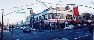
Bath Beach is a neighborhood in the New York City borough of Brooklyn, located at the southwestern edge of the borough on Gravesend Bay. The neighborhood borders Bensonhurst and New Utrecht to the northeast across 86th Street; Dyker Beach Park and Golf Course to the northwest across 14th Avenue; and Gravesend to the east across Stillwell Avenue.

Flatbush Avenue is a major avenue in the New York City Borough of Brooklyn. It runs from the Manhattan Bridge south-southeastward to Jamaica Bay, where it joins the Marine Parkway–Gil Hodges Memorial Bridge, which connects Brooklyn to the Rockaway Peninsula in Queens. The north end was extended from Fulton Street to the Manhattan Bridge as "Flatbush Avenue Extension".
The BMT Sea Beach Line is a rapid transit line of the BMT division of the New York City Subway, connecting the BMT Fourth Avenue Line at 59th Street via a four-track wide open cut to Coney Island in Brooklyn. It has at times hosted the fastest express service between Manhattan and Coney Island, since there are no express stations along the entire stretch, but now carries only local trains on the N service, which serves the entire line at all times. During rush hours, several W trains serve the line north of 86th Street.

Community boards of Brooklyn are New York City community boards in the borough of Brooklyn, which are the appointed advisory groups of the community districts that advise on land use and zoning, participate in the city budget process, and address service delivery in their district.

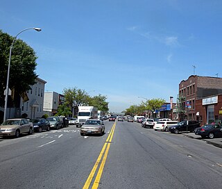
Bay Parkway is a 2.7-mile-long (7.82 km) boulevard in the west portion of the New York City borough of Brooklyn.
Kings Highway is a broad avenue that curves about the southern part of the Borough of Brooklyn in New York City. Its west end is at Bay Parkway and 78th Street. East of Ocean Avenue, the street is largely residential. It tracks eastward, then northeast, then north through Brooklyn and reaches East 98th Street in central Brooklyn. At that point, it flows into Howard Avenue to provide seamless access to Eastern Parkway, another major road in Brooklyn with side medians and service roads.

Coney Island Avenue is a road in the New York City borough of Brooklyn that runs north-south for a distance of roughly five miles, almost parallel to Ocean Parkway and Ocean Avenue. It begins at Brighton Beach Avenue in Coney Island and goes north to Park Circle at the southwest corner of Prospect Park, where it becomes Prospect Park Southwest. Near-parallel Ocean Parkway terminates five blocks south and three blocks west of that intersection, becoming the Prospect Expressway. Ocean Parkway originally extended north to Park Circle, where Coney Island Avenue meets Prospect Park, until construction of the Prospect Expressway replaced the northern half-mile of Ocean Parkway but included ramps to the edge of Prospect Park.
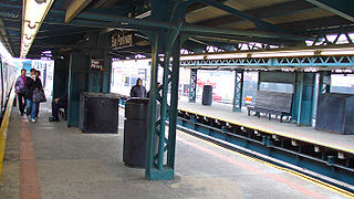
The Bay Parkway station is an express station on the BMT West End Line of the New York City Subway, located in Bensonhurst, Brooklyn at the intersection of Bay Parkway and 86th Street. The station is served by the D train at all times.

The B44 is a public transit line in Brooklyn, New York City, running mostly along Nostrand Avenue, as well as northbound on Rogers Avenue or New York Avenue and Bedford Avenue, between Sheepshead Bay and Williamsburg. Originally a streetcar line, it is now the B44 bus route, operated by the New York City Transit Authority.

The B63 is a bus route in Brooklyn, New York City, running mainly along Fifth Avenue and Atlantic Avenue between Fort Hamilton and Cobble Hill. Originally a streetcar line called the Fifth Avenue Line, it is now operated by the New York City Transit Authority as the Fifth/Atlantic Avenues bus.

The B6 constitutes a bus route between Bath Beach and East New York in Brooklyn, New York City. Originally operated by Brooklyn-Manhattan Transit, the route is operated by the MTA Regional Bus Operations under the New York City Transit Authority brand.
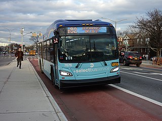
The B82 bus route constitutes a public transit line in central Brooklyn, New York City. It connects Starrett City in southeast Brooklyn with Coney Island on Brooklyn's southwestern coast. The B82 operates primarily via Kings Highway and Flatlands Avenue in southern Brooklyn. The route is operated by MTA Regional Bus Operations, under the New York City Bus and Select Bus Service brands.

The West End Line or New Utrecht Avenue Line was a surface transit line in Brooklyn, New York City, United States, running along New Utrecht Avenue and other streets between Coney Island and Sunset Park. Built by the Brooklyn, Bath and Coney Island Railroad as a steam line, it became a trolley line, along which elevated trains ran until the new elevated BMT West End Line opened. This route is no longer part of any bus line; its southern part was part of a bus route. In 2013, the B64 route to Coney Island was restored.
Stillwell Avenue is a major two-way north–south thoroughfare in southern Brooklyn and the central section of Coney Island. It is 2.4 miles (3.9 km) long and begins at a dead end at Riegelmann Boardwalk on Coney Island. The road goes north, leaving Coney Island, ending at Bay Parkway, where the road continues as the Bay Ridge Parkway. On December 11, 2008, it acquired the subsidiary name Polar Bear Club Walk, named for the Coney Island Polar Bear Club. The Stillwell Avenue/Surf Avenue intersection on Coney Island is the location of the Coney Island–Stillwell Avenue subway station, a major subway station in New York City.
Nostrand Avenue is a major street in Brooklyn, New York, that runs for 8 miles (13 km) north from Emmons Avenue in Sheepshead Bay to Flushing Avenue in Williamsburg, where it continues as Lee Avenue. It occupies the position of East 30th Street in the Brooklyn street grid. The street is named after the 17th century Dutch settler Gerret Noorstrandt.
Ocean Avenue is a major street in Brooklyn, New York that runs generally north-south and occupies the position of East 20th Street in the Brooklyn street grid, with East 19th Street to its west and East 21st Street to its east for most of its path. It runs east of and parallel to Ocean Parkway and Coney Island Avenue for most of its route. Except for a short stretch on the Manhattan Beach peninsula, Ocean Avenue starts in the south at Emmons Avenue in Sheepshead Bay just south of the Belt Parkway and continues north, ending at Flatbush Avenue at Willink Plaza after running for several blocks as the eastern edge of Prospect Park. A footbridge across Sheepshead Bay connects the two "Ocean Avenue" sections.
