
The Independent Subway System was a rapid transit rail system in New York City that is now part of the New York City Subway. It was first constructed as the Eighth Avenue Line in Manhattan in 1932. It was originally also known as the Independent City-Owned Subway System (ICOSS) or the Independent City-Owned Rapid Transit Railroad (ICORTR).
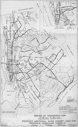
Since the opening of the original New York City Subway line in 1904, and throughout the subway's history, various official and planning agencies have proposed numerous extensions to the subway system. The first major expansion of the subway system was the Dual Contracts, a set of agreements between the City of New York and the IRT and the BRT. The system was expanded into the outer reaches of the Bronx, Brooklyn, and Queens, and it provided for the construction of important lines in Manhattan. This one expansion of the system provided for a majority of today's system.

The L 14th Street–Canarsie Local is a rapid transit service in the B Division of the New York City Subway. Its route emblem, or "bullet", is colored medium gray since it serves the BMT Canarsie Line.

Flatbush Avenue is a major avenue in the New York City Borough of Brooklyn. It runs from the Manhattan Bridge south-southeastward to Jamaica Bay, where it joins the Marine Parkway–Gil Hodges Memorial Bridge, which connects Brooklyn to the Rockaway Peninsula in Queens. The north end was extended from Fulton Street to the Manhattan Bridge as "Flatbush Avenue Extension".

Fulton Street is a long east–west street in northern Brooklyn, New York City. This street begins at the intersection of Adams Street and Joralemon Street in Brooklyn Heights, and runs eastward to East New York and Cypress Hills. At the border with Queens, Fulton Street becomes 91st Avenue, which ends at 84th Street in Woodhaven.
The Myrtle Avenue Line, also called the Myrtle Avenue Elevated, is a fully elevated line of the New York City Subway as part of the BMT division. The line is the last surviving remnant of one of the original Brooklyn elevated railroads. The remnant line operates as a spur branch from the Jamaica Line to Bushwick, Ridgewood, and Middle Village, terminating at its original eastern terminal across the street from Lutheran Cemetery. Until 1969, the line continued west into Downtown Brooklyn and, until 1944, over the Brooklyn Bridge to the Park Row Terminal in Manhattan.
The IND Fulton Street Line is a rapid transit line of the IND Division of the New York City Subway, running from the Cranberry Street Tunnel under the East River through central Brooklyn to a terminus in Ozone Park, Queens. The IND Rockaway Line branches from it just east of Rockaway Boulevard. The A train runs express during daytime hours and local at night on the underground portion of the line; it runs local on the elevated portion of the line at all times. The C train runs local on the underground portion of the line at all times except late nights.

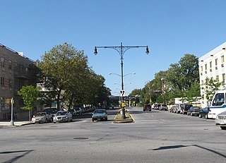
Myrtle Avenue is a 8.1-mile-long (13.0 km) street that runs from Duffield Street in Downtown Brooklyn to Jamaica Avenue in Richmond Hill, Queens, in New York City, United States. Myrtle is a main thoroughfare through the neighborhoods of Fort Greene, Clinton Hill, Bedford-Stuyvesant, Bushwick, Ridgewood, and Glendale.
DeKalb Avenue is a street in the New York City boroughs of Brooklyn and Queens.

The Myrtle–Wyckoff Avenues station is a New York City Subway station complex formed by the intersecting stations of the BMT Canarsie Line and the BMT Myrtle Avenue Line, served by the L and M trains at all times. It is located at Myrtle Avenue and Wyckoff Avenue in the Bushwick neighborhood of Brooklyn and the Ridgewood neighborhood of Queens. The complex is connected by a set of stairs and several elevators and escalators between the elevated and underground levels. The station was renovated completely from 2004 to 2008.

The B54 is a bus route on Myrtle Avenue in Brooklyn, New York City. The line travels between Downtown Brooklyn in the west and Myrtle–Wyckoff Avenues station in the east. The B54 operates from MTA New York City Bus's Fresh Pond Depot in Ridgewood, Queens. The route serves only the section of Myrtle Avenue within Brooklyn; the section within Queens is served by the Q55 bus.

The DeKalb Avenue Line is a public transit line in Brooklyn and Queens, New York City, running mostly along DeKalb Avenue, as well as eastbound on Lafayette Avenue, between Downtown Brooklyn and Ridgewood, Queens. Originally a streetcar line, it is now the B38 DeKalb/Lafayette Avenues bus route, operated by the New York City Transit Authority.

Flushing Avenue is a street running through northern Brooklyn and western Queens, beginning at Nassau Street in Fort Greene, Brooklyn, and ending at Grand Avenue in Maspeth. It divides the neighborhood of Williamsburg from Clinton Hill and East Williamsburg from Bushwick. After crossing the Queens border, the avenue serves as the dividing line between Ridgewood, Queens and West Maspeth. Flushing Avenue then terminates in Maspeth. Despite its name, however, the avenue does not extend to Flushing.

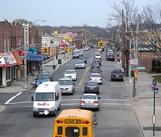
Jamaica Avenue is a major avenue in the New York City boroughs of Brooklyn and Queens, New York, in the United States. Jamaica Avenue's western end is at Broadway and Fulton Street, as a continuation of East New York Avenue, in Brooklyn's East New York neighborhood. Physically, East New York Avenue connects westbound to New York Avenue, where East New York Avenue changes names another time to Lincoln Road; Lincoln Road continues to Ocean Avenue in the west, where it ends. Its eastern end is at the city line in Bellerose, Queens, where it becomes Jericho Turnpike to serve the rest of Long Island. The section of Jamaica Avenue designated as New York State Route 25 runs from Braddock Avenue to the city line, where Jamaica Avenue becomes Jericho Turnpike.
Nostrand Avenue is a major street in Brooklyn, New York, that runs for 8 miles (13 km) north from Emmons Avenue in Sheepshead Bay to Flushing Avenue in Williamsburg, where it continues as Lee Avenue. It occupies the position of East 30th Street in the Brooklyn street grid. It is named after Gerret Noorstrandt whose family was one of the first families that settled in New Utrecht, Brooklyn, when New York was still a Dutch colony. Between 1790 and 1820, the Nostrand family owned approximately 43 enslaved people.
Metropolitan Avenue is a major east-west street in Queens and northern Brooklyn, New York City. Its western end is at the East River in Williamsburg, Brooklyn, and the eastern end at Jamaica Avenue in Jamaica, Queens. The avenue was constructed in 1816 as the Williamsburgh and Jamaica Turnpike, though previously it served as an Indian trail.

Broadway is an avenue in the New York City borough of Brooklyn that extends from the East River in the neighborhood of Williamsburg in a southeasterly direction to East New York for a length of 4.32 miles (6.95 km). It was named for the Broadway in Manhattan. The East New York terminus is a complicated intersection with East New York Avenue, Fulton Street, Jamaica Avenue, and Alabama Avenue. The BMT Jamaica Line of the New York City Subway runs on elevated tracks over Broadway from the Williamsburg Bridge to East New York on its way to Queens. Broadway forms the boundary between the neighborhoods of Bushwick, which lies above Broadway to the northeast, and Bedford–Stuyvesant, which is to the southwest.

