IND Fulton Street Line

Last updated

IND Fulton Street Line
NYCS-bull-trans-A-Std.svg NYCS-bull-trans-C-Std.svg
The IND Fulton Street Line is served by the A and C.
Overview
Owner City of New York
Termini
Stations22
Service
Type Rapid transit
System New York City Subway
Operator(s) New York City Transit Authority
Daily ridership102,615 [1]
History
Opened1915–1956
Technical
Number of tracks2-4
CharacterUnderground (Brooklyn)
Elevated (Queens)
Track gauge 4 ft 8+12 in (1,435 mm)
Electrification Direct Current traction
Route map

Contents

BSicon utCONTg.svg
BSicon utSTR.svg
BSicon utCONTg.svg
BSicon utKRWgl+l.svg
BSicon utKRWgr+r.svg
BSicon lACC-L.svg
BSicon utBHF-L.svg
BSicon lACC-R.svg
BSicon utBHF-R.svg
Jay Street–MetroTech
BSicon utdCONTgq.svg
BSicon utKRZto.svg
BSicon utKRZto.svg
BSicon utdCONTfq.svg
BSicon utBS2+l.svg
BSicon utBS2c4.svg
BSicon lHSTACC~F.svg
BSicon utBS2c1.svg
BSicon utBS2+r.svg
BSicon utSTR.svg
BSicon lHSTACC~G.svg
BSicon uxtKRWg+l.svg
BSicon ulCONTg@F.svg
BSicon utKRWr.svg
BSicon utSTR.svg
BSicon utBHF-L.svg
BSicon utBHF-R.svg
Hoyt–Schermerhorn Streets
BSicon utABZg+l.svg
BSicon utKRZto.svg
BSicon utSTRr.svg
BSicon utHST.svg
BSicon utHST.svg
Lafayette Avenue
BSicon utCONTf.svg
BSicon utHST.svg
Clinton–Washington Avenues
BSicon uhCONTgq.svg
BSicon uKACCeq.svg
BSicon utHSTACC.svg
Franklin Avenue
BSicon utBHF.svg
Nostrand Avenue
BSicon utHST.svg
Kingston–Throop Avenues
BSicon utACC.svg
Utica Avenue
BSicon utHST.svg
Ralph Avenue
BSicon utHST.svg
Rockaway Avenue
BSicon uhCONTgq.svg
BSicon utBHF.svg
BSicon uhSTRq.svg
BSicon uhCONTfq.svg
Broadway Junction
BSicon tCONTgq.svg
BSicon tSTRq.svg
BSicon utSTR.svg
BSicon tCONTfq.svg
BSicon uhCONTgq.svg
BSicon utSTR.svg
BSicon uhSTRq.svg
BSicon uhCONTfq.svg
BSicon utHST.svg
Liberty Avenue
BSicon utHST.svg
Van Siclen Avenue
BSicon utHST.svg
Shepherd Avenue
BSicon utACC.svg
Euclid Avenue
BSicon PORTALl.svg
BSicon uKDSTaq.svg
BSicon utBS2l.svg
BSicon utABZr+r.svg
BSicon utBS2c3.svg
BSicon exlENDE@Gq.svg
BSicon lKRZo+L.svg
BSicon utSTR~L.svg
BSicon uextSTRq.svg
BSicon lKRZo+R.svg
BSicon utSTR~R.svg
BSicon uetABZgr.svg
provision for extension
BSicon utdSTRc2.svg
BSicon utdSTR.svg
BSicon ulvHST@G-.svg
BSicon utdSTR3.svg
Grant Avenue
BSicon utdABZg+1.svg
BSicon utcSTRc4.svg
BSicon uexhCONTg.svg
BSicon utKRWl.svg
BSicon hPORTALr.svg
BSicon uxhKRWg+r.svg
BSicon uhHST.svg
80th Street
BSicon uhHST.svg
88th Street
BSicon uhHST.svg
Rockaway Boulevard
BSicon lhSTRa@fq.svg
BSicon uCONTgq.svg
BSicon uhABZgr.svg
BSicon uhHST.svg
104th Street
BSicon uhHST.svg
111th Street
BSicon uhKACCe.svg
Ozone Park–Lefferts Boulevard
Legend

BSicon utBHF.svg
Express station
BSicon utHST.svg
Local station
BSicon uetHST.svg
Closed station

The IND Fulton Street Line is a rapid transit line of the IND Division of the New York City Subway, running from the Cranberry Street Tunnel under the East River through central Brooklyn to a terminus in Ozone Park, Queens. The IND Rockaway Line branches from it just east of Rockaway Boulevard. The A train runs express during daytime hours and local at night on the underground portion of the line; it runs local on the elevated portion of the line at all times. The C train runs local on the underground portion of the line at all times except late nights.

The line runs primarily along Fulton Street, Pitkin Avenue, and Liberty Avenue. The underground portion, which constitutes the majority of the line, was built for the city-owned Independent Subway System (IND), opening between 1936 and 1956. The elevated portion in Queens was originally part of the Brooklyn–Manhattan Transit Corporation (BMT)'s Fulton Street elevated line; the Elevated in Brooklyn was closed and demolished in stages with the opening of the subway line.

Description and service

The following services use part or all of the IND Fulton Street Line: [2]

ServiceBetween
 Time period Hoyt–
Schermerhorn Sts

Euclid Ave
Euclid Ave
Rockaway Boulevard
Rockaway Boulevard
Ozone Park–Lefferts Blvd
NYCS-bull-trans-A-Std.svg All except nightsexpresslocal
Late nightslocalshuttle
NYCS-bull-trans-C-Std.svg All except nightslocalno service
Late nightsno service

Under Fulton Street, the line is mainly single level, except at Nostrand Avenue, where the express tracks are on the upper level and the local tracks are on the lower level. [3] During the subway line's construction in the late 1930s and early 1940s, the old, now-demolished BMT Fulton Street Elevated (which the IND line replaced) had to be supported.

The stations along Liberty Avenue in Queens, from 80th Street–Hudson Street through Ozone Park–Lefferts Boulevard, as well as the current three-track elevated structure, were built for the elevated Fulton Street Line in 1915 as part of the BMT's portion of the Dual Contracts. This was the only section of the Fulton El that was built specifically to handle steel subway cars, as opposed to lighter wooden elevated cars. [4]

The current service pattern along the line is one of the newest in the New York City Subway system. Prior to December 1988, express service was only provided during rush hours, and before 1999, all trains ran local on weekends and weekday evenings after 9:00 pm. Since May 2, 1999, A trains run express along the line and C trains run local except during late nights, when A trains make all stops.

Route

Entering Brooklyn via the Cranberry Street Tunnel as a two-track line, the IND Eighth Avenue Line travels east on Cranberry Street, then south on Jay Street. It becomes the Fulton Street Line at an interlocking north of Jay Street–MetroTech while briefly running parallel with the IND Culver Line. It turns away from the Culver Line onto Schermerhorn Street to the six-track Hoyt–Schermerhorn Streets station, which it shares with the Brooklyn–Queens Crosstown Line. The local tracks are unused at Hoyt-Schermerhorn Streets, but connect to the abandoned Court Street station which is now the site of the New York City Transit Museum. At this point, the line becomes a four-track system until Euclid Avenue. [3]

The line continues east under Schermerhorn Street to the intersections of Third Avenue and Flatbush Avenue, across them onto Lafayette Avenue and then finally onto Fulton Street until Broadway Junction. [3]

After Broadway Junction, the line leaves Fulton Street via Truxton Street, crosses Broadway, curves through a corner of the East New York Yard, crosses Jamaica Avenue and then south on Pennsylvania Avenue. It then turns east onto Pitkin Avenue until Euclid Avenue station. East of Euclid Avenue there are track connections to Pitkin Yard, and from either the express or local tracks to the two-track line towards Grant Avenue station. The four mainline trackways continue east on Pitkin Avenue, disused, and end at approximately Elderts Lane. [3] [5]

Past Grant Avenue, the line joins the former Fulton Street elevated via a ramp as it enters Queens, swinging somewhat north until it is over Liberty Avenue. [3] [6] [7] Here, it becomes a three-track line, with the center track coming from Pitkin Yard. Just past Rockaway Boulevard, the IND Rockaway Line branches southward while the Fulton Street Line continues over Liberty Avenue to its terminus at Lefferts Boulevard. [3] [6] [8]

History

The Fulton Street subway was the city-owned Independent System (IND)'s main line from Downtown Brooklyn to southern Queens. [9] Along with the IND Eighth Avenue Line, it was also alternately known as the Washington Heights−East New York Line. [10] The subway was built to replace the elevated Fulton Street Elevated, which ran above Fulton Street from Boerum Place to Van Sinderen Avenue, south along Van Sinderen Avenue to Pitkin Avenue, down Pitkin Avenue to Euclid Avenue, and up Euclid Avenue, where it turned east on Liberty Avenue. As in Manhattan, the older elevated tracks were seen as depressing real estate values. The subway was designed to follow the elevated line as close as possible. It was routed along Schermerhorn Street due to the presence of the IRT subway already below Fulton Street in downtown Brooklyn and along Pennsylvania Avenue in East New York so that wider curves could be built, allowing faster speeds. The local tracks were always designed to terminate in downtown Brooklyn as local elevated trains would terminate at the Sands Street station. The groundbreaking for the line was held on April 16, 1929, at Fulton Street and Arlington Place, near the future Nostrand Avenue station. [11] The line was opened from Jay Street to Rockaway Avenue on April 9, 1936, including the stub terminal at Court Street. [12] [13]

To allow the subway line to be built, the following streets were widened from 60 to 80 feet (18 to 24 m): Jay Street between Nassau Street to Fulton Street, Smith Street between Fulton Street and Atlantic Avenue, and Schermerhorn Street between Smith Street and Nevins Street. The land acquired to widen the streets was valued at $1.75 million. [14]

Further construction was delayed by funding problems due to the Great Depression in the 1930s. [5] This was temporarily solved by federal Works Progress Administration funding starting in 1936. The portion continuing from east of Rockaway Avenue along Pennsylvania and Pitkin Avenues to Crystal Street began construction in 1938. [10] [15] The next portion east from Crystal Street to around Grant Avenue, including the Euclid Avenue terminal and the Pitkin Yard, began construction in 1940. [15] [16] The progress lasted only a few years, as all work on the last portions in Brooklyn was stopped by December 1942 shortly after the United States entered World War II, with Broadway−East New York complete but not in operation due to lack of signal equipment, and the remaining stations to Euclid Avenue as unfinished shells. [5] [10] [15] [17] [18]

The Court Street station was closed on June 1, 1946, due to low ridership and because of its close proximity to the Hoyt–Schermerhorn Streets station. [17] [19] After World War II ended, workers and materials became available for public use again. The badly needed extension to the more efficient terminal at Broadway−East New York (the current Broadway Junction station) opened on December 30, 1946. [5] [20]

The extension of the Fulton Street Line, the completion of which had been delayed due to war priorities, was finished by funds obtained by Mayor William O'Dwyer and was placed in operation on November 28, 1948, running along Pennsylvania Avenue and Pitkin Avenue to Euclid Avenue near the Queens border. Forty additional R10 cars were placed into service for the extension. The cost of the extension was about $46.5 million. It included the construction of the new Pitkin Avenue Storage Yard, which could accommodate 585 subway cars on 40 storage tracks. [4] [5] [10] [20] [21] Because these stations were completed later than the rest of the line, they received different design features than other IND stations, including different wall tiles and fluorescent lighting. [5] [10] [22]

The Fulton Street express tracks were not used in regular service until October 24, 1949. A trains began running express during rush hours to Broadway–East New York, with E trains extended to provide local service. [23] The express reduced travel time by five minutes. [24]

In 1953, the platforms were lengthened at Ralph Avenue and Broadway–East New York to 660 feet (200 m) to allow E trains to run eleven car trains. The E began running eleven car trains during rush hours on September 8, 1953. The extra train car increased the total carrying capacity by 4,000 passengers. The lengthening project cost $400,000. [25] [26] [27]

In late 1952, the Board of Transportation began construction on a connection between the IND and both the Fulton El and the Rockaway Beach Branch of the Long Island Rail Road, which included a new underground station at Grant Avenue. [28] [29] [30] [31] The connection from the 80th Street elevated station to the rest of the BMT Fulton Elevated was severed on April 26, 1956, and the IND was extended east (track direction south) from Euclid Avenue via the intermediate station at Grant Avenue, and a connecting ramp (known as the Grant Avenue ramp). [4] [6] [32] The new service to Lefferts Boulevard began three days later. [4] [6] [8] [33] On June 28, 1956, the connection to the IND Rockaway Line east of Rockaway Boulevard was opened. [4] [8] [34] [35] [36] [37]

The 2015–2019 Metropolitan Transportation Authority Capital Plan called for the Fulton Street Line's Clinton–Washington Avenues, Kingston–Throop Avenues, and Van Siclen Avenue stations, along with 30 others, to undergo a complete overhaul as part of the Enhanced Station Initiative. Updates would include cellular service, Wi-Fi, USB charging stations, interactive service advisories and maps, improved signage, and improved station lighting. [38] [39] However, in April 2018, it was announced that cost overruns had forced the MTA to reduce the number of subway stations included in the program from 33 stations to 20. The stations to be renovated along the IND Fulton Street Line were among the 13 stations without funding, which will be pushed back to the 2020–2024 Capital Plan. [40]

Second System planned route

Early in the planning of the subway, the city considered recapturing parts of the BMT Jamaica Line, [41] which had been built under the Dual Contracts. This would have created two branches of the Fulton Street Subway east of Broadway Junction. Bellmouths were built into the outer walls of the subway tunnel just east of the Broadway Junction station for a future connection. [3]

The extension of the IND Fulton Street Line would have included a station at Cross Bay Boulevard in Ozone Park. Cross Bay Bl Pitkin Av td 15.jpg
The extension of the IND Fulton Street Line would have included a station at Cross Bay Boulevard in Ozone Park.

The IND Fulton Street Line was supposed to be extended farther east into Queens as part of the IND Second System, via an extension of the Fulton Elevated or a new subway. The line would have gone as far as Springfield Boulevard in Queens Village or 229th Street in Cambria Heights, both near the Nassau County border. The line would have also had a spur to the Rockaways. [5] [9] [42] [43] [44]

The 1929 Second System plan suggested recapturing and extending the Fulton elevated along Liberty, Brinkerhoff and Hollis Avenues to Springfield Boulevard, near Hempstead Turnpike, Belmont Park, and the Queens Village LIRR Station. [5] [9] [43] The 1939 plan, meanwhile, proposed extending the subway along Pitkin Avenue to Cross Bay Boulevard in South Ozone Park, then along Linden Boulevard to Cambria Heights near the Cross Island Parkway. A spur would have branched off east of Cross Bay Boulevard, turning south to join with the former Rockaway Beach Branch of the Long Island Rail Road (now the IND Rockaway Line). [5] [42] [44] This extended Fulton Street Line would have also facilitated service from the planned Second Avenue Subway via a river tunnel from Lower Manhattan to the then-terminal station at Court Street. [42] [44] [45]

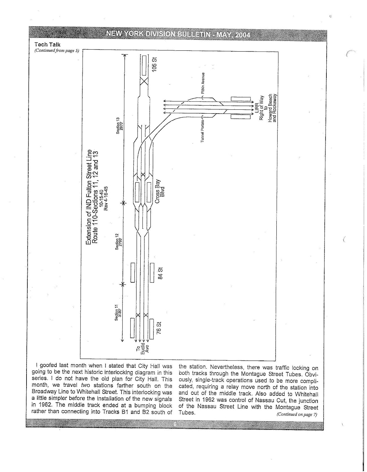
In a 1940 plan, which was revised in 1945, the IND Fulton Street Line would connect to the IND Rockaway Line in a similar manner to the 1939 plan, via an extension of the subway under Pitkin Avenue. The line, east of Euclid Avenue, would be 4 tracks, with local stations at 76th Street and 84th Street, and an express station at Cross Bay Boulevard. At Cross Bay Boulevard, a flying junction would let the local tracks cross over to the inside and the express tracks cross over to the outside. The layout would be similar to that of Manhattan's 168th Street station. East of Cross Bay Boulevard, another flying junction would bring a two-track branch over the line to a pair of portals north of Aqueduct–North Conduit Avenue station. Meanwhile, the Fulton Street Line's four tracks would merge into two tracks, and end at 105th Street (today's Aqueduct Racetrack), where a scissors crossover would be present just west of the station. Crossovers would also be located between the local and express pair of tracks east of 76th Street, and between the two express tracks east of Cross Bay Boulevard. [46]

Currently the line ends at Lefferts Boulevard in Ozone Park (the former end of the Fulton El), and only the Rockaway extension was completed. [6] [8] The mainline tracks that go past the Euclid Avenue station were to be part of a 4-track line to Cambria Heights. [5]

Station listing

Station service legend
NYCS-SSI-alltimes.svg Stops all times
NYCS-SSI-allexceptnights.svg Stops all times except late nights
NYCS-SSI-nightsonly.svg Stops late nights only
NYCS-SSI-rushpeak.svg Stops rush hours in the peak direction only
Time period details
Wheelchair symbol.svg Station is compliant with the Americans with Disabilities Act
Wheelchair symbol.svg  Station is compliant with the Americans with Disabilities Act
in the indicated direction only
Wheelchair symbol.svg  
Aiga elevator.svg Elevator access to mezzanine only
Neighborhood
(approximate)
Wheelchair symbol.svg StationTracksServicesOpenedTransfers and notes
Brooklyn
Begins as a continuation of the IND Eighth Avenue Line express tracks ( A   NYCS-SSI-alltimes.svg C   NYCS-SSI-allexceptnights.svg );
with connecting tracks to the IND Sixth Avenue Line local tracks (no regular service)
Downtown Brooklyn Wheelchair symbol.svg Jay Street–MetroTech express A   NYCS-SSI-alltimes.svg C   NYCS-SSI-allexceptnights.svg February 1, 1933 IND Culver Line ( F   NYCS-SSI-alltimes.svg <F> NYCS-SSI-rushpeak.svg )
BMT Fourth Avenue Line ( N   NYCS-SSI-nightsonly.svg R   NYCS-SSI-alltimes.svg W   NYCS-SSI-rushonly.svg )
Local tracks begin
Wheelchair symbol.svg Court Street localApril 9, 1936Closed 1946, reopened 1976 as the New York Transit Museum
Local tracks continue east from Court Street; Express tracks continue south then east from Jay Street–MetroTech
Aiga elevator.svg Hoyt–Schermerhorn Streets all A   NYCS-SSI-alltimes.svg C   NYCS-SSI-allexceptnights.svg April 9, 1936 IND Crosstown Line ( G   NYCS-SSI-alltimes.svg )
Local tracks, and platforms between local and express tracks, unused
Fort Greene Lafayette Avenue local A   NYCS-SSI-nightsonly.svg C   NYCS-SSI-allexceptnights.svg April 9, 1936
Clinton Hill Clinton–Washington Avenues local A   NYCS-SSI-nightsonly.svg C   NYCS-SSI-allexceptnights.svg April 9, 1936
Bedford–Stuyvesant Wheelchair symbol.svg Franklin Avenue local A   NYCS-SSI-nightsonly.svg C   NYCS-SSI-allexceptnights.svg April 9, 1936 BMT Franklin Avenue Line ( S   NYCS-SSI-alltimes.svg )
Nostrand Avenue all A   NYCS-SSI-alltimes.svg C   NYCS-SSI-allexceptnights.svg April 9, 1936local tracks on lower level, express tracks on upper level
B44 Select Bus Service
Kingston–Throop Avenues local A   NYCS-SSI-nightsonly.svg C   NYCS-SSI-allexceptnights.svg April 9, 1936
Wheelchair symbol.svg Utica Avenue all A   NYCS-SSI-alltimes.svg C   NYCS-SSI-allexceptnights.svg April 9, 1936 B46 Select Bus Service
Ralph Avenue local A   NYCS-SSI-nightsonly.svg C   NYCS-SSI-allexceptnights.svg April 9, 1936
Rockaway Avenue local A   NYCS-SSI-nightsonly.svg C   NYCS-SSI-allexceptnights.svg April 9, 1936
East New York Broadway Junction all A   NYCS-SSI-alltimes.svg C   NYCS-SSI-allexceptnights.svg December 30, 1946 BMT Canarsie Line ( L   NYCS-SSI-alltimes.svg )
BMT Jamaica Line ( J   NYCS-SSI-alltimes.svg Z   NYCS-SSI-rushpeak.svg )
originally Broadway-East New York
Liberty Avenue local A   NYCS-SSI-nightsonly.svg C   NYCS-SSI-allexceptnights.svg November 28, 1948
Van Siclen Avenue local A   NYCS-SSI-nightsonly.svg C   NYCS-SSI-allexceptnights.svg November 28, 1948
Shepherd Avenue local A   NYCS-SSI-nightsonly.svg C   NYCS-SSI-allexceptnights.svg November 28, 1948
Wheelchair symbol.svg Euclid Avenue all A   NYCS-SSI-alltimes.svg C   NYCS-SSI-allexceptnights.svg November 28, 1948
Connecting tracks to Pitkin Yard and Grant Avenue spurs; mainline tracks dead-end
City Line Grant Avenue all A   NYCS-SSI-alltimes.svg April 29, 1956
Queens
Single express track begins from Pitkin Yard (no regular service)
Ozone Park 80th Street local A   NYCS-SSI-alltimes.svg September 25, 1915 [47]
88th Street local A   NYCS-SSI-alltimes.svg September 25, 1915 [47]
Rockaway Boulevard local A   NYCS-SSI-alltimes.svg September 25, 1915 [47] Q52/Q53 Select Bus Service
IND Rockaway Line splits ( A   NYCS-SSI-alltimes.svg )
104th Street local A   NYCS-SSI-alltimes.svg September 25, 1915 [47]
Richmond Hill 111th Street local A   NYCS-SSI-alltimes.svg September 25, 1915 [47]
Wheelchair symbol.svg Ozone Park–Lefferts Boulevard all A   NYCS-SSI-alltimes.svg September 25, 1915 [47] Q10 bus to JFK Airport

Related Research Articles

<span class="mw-page-title-main">A (New York City Subway service)</span> New York City Subway service

The A Eighth Avenue Express is a rapid transit service in the B Division of the New York City Subway. Its route emblem, or "bullet", is colored blue since it is a part of the IND Eighth Avenue Line in Manhattan.

<span class="mw-page-title-main">E (New York City Subway service)</span> New York City Subway service

The E Eighth Avenue Local is a rapid transit service in the B Division of the New York City Subway. Its route emblem, or "bullet", is blue since it uses the IND Eighth Avenue Line in Manhattan.

<span class="mw-page-title-main">Independent Subway System</span> Defunct subway operator in New York City

The Independent Subway System was a rapid transit rail system in New York City that is now part of the New York City Subway. It was first constructed as the Eighth Avenue Line in Manhattan in 1932. It was originally also known as the Independent City-Owned Subway System (ICOSS) or the Independent City-Owned Rapid Transit Railroad (ICORTR).

<span class="mw-page-title-main">Proposed expansion of the New York City Subway</span>

Since the opening of the original New York City Subway line in 1904, and throughout the subway's history, various official and planning agencies have proposed numerous extensions to the subway system. The first major expansion of the subway system was the Dual Contracts, a set of agreements between the City of New York and the IRT and the BRT. The system was expanded into the outer reaches of the Bronx, Brooklyn, and Queens, and it provided for the construction of important lines in Manhattan. This one expansion of the system provided for a majority of today's system.

<span class="mw-page-title-main">Rockaway Boulevard station</span> New York City Subway station in Queens

The Rockaway Boulevard station is a station on the IND Fulton Street Line of the New York City Subway. Located at the intersection of Rockaway Boulevard, Woodhaven and Cross Bay Boulevards, and Liberty Avenue in Ozone Park, Queens, it is served by the A train at all times.

<span class="mw-page-title-main">Euclid Avenue station (IND Fulton Street Line)</span> New York City Subway station in Brooklyn

The Euclid Avenue station is an express station on the IND Fulton Street Line of the New York City Subway, located at the intersection of Euclid and Pitkin Avenues in East New York, Brooklyn. It is served by the A train at all times and is the southern terminal for the C train at all times except nights. During nights, this is the northern terminal for the Lefferts Boulevard shuttle train from Ozone Park, Queens.

<span class="mw-page-title-main">Liberty Avenue station</span> New York City Subway station in Brooklyn

The Liberty Avenue station is a local station on the IND Fulton Street Line of the New York City Subway, located at the intersection of Liberty and Pennsylvania Avenues in East New York, Brooklyn. It is served by the C train at all times except nights, when the A train takes over service.

<span class="mw-page-title-main">Van Siclen Avenue station (IND Fulton Street Line)</span> New York City Subway station in Brooklyn

The Van Siclen Avenue station is a local station on the IND Fulton Street Line of the New York City Subway. Located at the intersection of Van Siclen and Pitkin Avenues in the East New York neighborhood of Brooklyn, it is served by the C train at all times except nights, when the A train takes over service.

<span class="mw-page-title-main">Shepherd Avenue station</span> New York City Subway station in Brooklyn

The Shepherd Avenue station is a local station on the IND Fulton Street Line of the New York City Subway. Located at the intersection of Shepherd and Pitkin Avenues in the East New York neighborhood of Brooklyn, it is served by the C train at all times except nights, when the A train takes over service.

<span class="mw-page-title-main">80th Street station (IND Fulton Street Line)</span> New York City Subway station in Queens

The 80th Street station is a station on the IND Fulton Street Line of the New York City Subway. Located on Liberty Avenue at 80th Street in Ozone Park, Queens, it is served by the A train at all times.

<span class="mw-page-title-main">Grant Avenue station (IND Fulton Street Line)</span> New York City Subway station in Brooklyn

The Grant Avenue station is a station on the IND Fulton Street Line of the New York City Subway. Located at Grant Avenue just north of Pitkin Avenue in City Line, Brooklyn, near the border between the boroughs of Brooklyn and Queens, it is served by the A train at all times. The station is the line's easternmost stop in Brooklyn; the Fulton Street Line continues east into Queens via the Fulton Street Elevated.

<span class="mw-page-title-main">88th Street station</span> New York City Subway station in Queens

The 88th Street station is a station on the IND Fulton Street Line of the New York City Subway. Located on Liberty Avenue at 88th Street in Ozone Park, Queens, it is served by the A train at all times.

<span class="mw-page-title-main">111th Street station (IND Fulton Street Line)</span> New York City Subway station in Queens

The 111th Street station is a station on the IND Fulton Street Line of the New York City Subway, located on Liberty Avenue at 111th Street in Richmond Hill, Queens. The station is served by the A train at all times.

<span class="mw-page-title-main">104th Street station (IND Fulton Street Line)</span> New York City Subway station in Queens

The 104th Street station is a station on the IND Fulton Street Line of the New York City Subway, located on Liberty Avenue at 104th Street in Ozone Park, Queens. The station is served by the Lefferts Boulevard branch of the A train at all times.

<span class="mw-page-title-main">Ozone Park–Lefferts Boulevard station</span> New York City Subway station in Queens

The Ozone Park–Lefferts Boulevard station is an elevated terminal station on the IND Fulton Street Line of the New York City Subway, located at the intersection of Lefferts Boulevard and Liberty Avenue in Queens. It serves as the terminus of the A route's Lefferts Boulevard branch. Despite its name, the station is not actually located in Ozone Park, but rather in the adjacent neighborhood of South Richmond Hill.

<span class="mw-page-title-main">Broadway Junction station</span> New York City Subway station complex in Brooklyn

The Broadway Junction station is a New York City Subway station complex shared by the elevated BMT Canarsie Line and BMT Jamaica Line, and the underground IND Fulton Street Line. It was also served by trains of the Fulton Street Elevated until that line closed in 1956. It is located roughly at the intersection of Broadway, Fulton Street and Van Sinderen Avenue at the border of Bedford–Stuyvesant and East New York, Brooklyn. The complex is served by the A, J, and L trains at all times; the C train at all times except late nights; and the Z train during rush hours in the peak direction only.

The IND Rockaway Line is a rapid transit line of the IND Division of the New York City Subway, operating in Queens. It branches from the IND Fulton Street Line at Rockaway Boulevard, extending over the Jamaica Bay, into the Rockaways. At its southern end in the Rockaways, the line has two branches: one traveling east to Far Rockaway–Mott Avenue and one traveling west to Rockaway Park–Beach 116th Street. The A train serves the line on the Far Rockaway branch, as well as on the section north of Hammels Wye. The Rockaway Park Shuttle runs between Broad Channel and Rockaway Park. Five rush hour A trains provide service between Rockaway Park and Manhattan in the peak direction.

<span class="mw-page-title-main">Fulton Street Line (elevated)</span> Former New York City rapid transit line

The Fulton Street Line, also called the Fulton Street Elevated or Kings County Line, was an elevated rail line mostly in Brooklyn, New York City, United States. It ran above Fulton Street from Fulton Ferry, Brooklyn, in Downtown Brooklyn east to East New York, and then south on Van Sinderen Avenue (southbound) and Snediker Avenue (northbound), east on Pitkin Avenue, north on Euclid Avenue, and east on Liberty Avenue to Ozone Park, Queens.

References

  1. "Annual Subway Ridership (2017–2022)". Metropolitan Transportation Authority. 2022. Retrieved November 8, 2023.
  2. "Subway Service Guide" (PDF). Metropolitan Transportation Authority. September 2019. Retrieved September 22, 2019.
  3. 1 2 3 4 5 6 7 Dougherty, Peter (2006) [2002]. Tracks of the New York City Subway 2006 (3rd ed.). Dougherty. OCLC   49777633 via Google Books.
  4. 1 2 3 4 5 Sparberg, Andrew J. (October 2014). From a Nickel to a Token: The Journey from Board of Transportation to MTA. Fordham University Press. ISBN   978-0-8232-6190-1.
  5. 1 2 3 4 5 6 7 8 9 10 Raskin, Joseph B. (2013). The Routes Not Taken: A Trip Through New York City's Unbuilt Subway System. New York, New York: Fordham University Press. doi:10.5422/fordham/9780823253692.001.0001. ISBN   978-0-82325-369-2.
  6. 1 2 3 4 5 "First Leg of Rockaways Transit Opened at Cost of $10,154,702" (PDF). The New York Times . April 30, 1956. Retrieved June 29, 2015.
  7. "MTA Neighborhood Maps: neighborhood". Metropolitan Transportation Authority. 2018. Retrieved October 1, 2018.
  8. 1 2 3 4 Freeman, Ira Henry (June 28, 1956). "Rockaway Trains to Operate Today" (PDF). The New York Times . Retrieved June 29, 2015.
  9. 1 2 3 Duffus, R.L. (September 22, 1929). "Our Great Subway Network Spreads Wider; New Plans of Board of Transportation Involve the Building of More Than One Hundred Miles of Additional Rapid Transit Routes for New York" (PDF). The New York Times . Retrieved August 19, 2015.
  10. 1 2 3 4 5 "Trains Roll on $47,000,000 Fulton St. Subway Extension". Brooklyn Daily Eagle . November 29, 1948. p. 2. Retrieved October 9, 2015 via Newspapers.com.
  11. "New Fulton Street Subway Officially Started as Byrne Turns Earth; Ground is Broken For Subway Line Along Fulton St.; Byrne Turns First Spade of Arlington Pl. Earth as Merchants Applaud". Brooklyn Daily Eagle . April 17, 1929. p. 4. Retrieved August 28, 2016 via Newspapers.com.
  12. "Two Subway Links Start Wednesday". The New York Times . April 6, 1936. p. 23. Retrieved October 7, 2011.
  13. "New Subway Link Opened By Mayor; He Tells 15,000 in Brooklyn It Will Be Extended to Queens When Red Tape Is Cut". The New York Times. April 9, 1936. ISSN   0362-4331 . Retrieved August 15, 2016.
  14. "Transit Board Land Ceded To Boroughs; New Street Areas, Valued at $10,000,000, Are in Manhattan, Brooklyn and the Bronx. Acquired In Condemnation Widening of Thoroughfares for Subways Also Has Increased Real Estate Values". The New York Times. January 28, 1932. Retrieved June 28, 2018.
  15. 1 2 3 Linder, Bernard (February 2006). "Fulton Street Subway". New York Division Bulletin. Electric Railroader's Association. 49 (2): 2. Retrieved August 27, 2016.
  16. "Subway Contract Given to Boro Firm". Brooklyn Daily Eagle . September 12, 1940. p. 2. Retrieved August 27, 2016 via Newspapers.com.
  17. 1 2 Blauvelt, Paul (June 9, 1946). "Shortages Snarl $50,000,000 Tube Links". Brooklyn Daily Eagle . p. 21. Retrieved October 9, 2015 via Newspapers.com.
  18. Kramer, Frederick A. (1990). Building the Independent Subway. Quadrant Press. ISBN   9780915276509.
  19. Foley, A.J. (1946). "Sign for the Closing of the Court Street Station, 1946 ; IND Crosstown Line". New York Transit Museum. Retrieved August 28, 2016.
  20. 1 2 Report for the three and one-half years ending June 30, 1949. New York City Board of Transportation. 1949. hdl:2027/mdp.39015023094926.
  21. "Fulton Subway Stations Open After All-Night 'Dry Runs'". Brooklyn Daily Eagle . November 28, 1948. Archived from the original on October 28, 2016. Retrieved October 9, 2015 via Newspapers.com.
  22. "Last Word in Subways and Cars for Boro". Brooklyn Daily Eagle . November 23, 1948. p. 8. Retrieved October 9, 2015 via Newspapers.com.
  23. "IND Faster Service Will Start Sunday" (PDF). New York Times. October 20, 1949. Retrieved February 20, 2016.
  24. "Improving Subway Service". New York Daily News. October 1, 1949. Retrieved November 5, 2018.
  25. Ingalls, Leonard (August 28, 1953). "2 Subway Lines to Add Cars, Another to Speed Up Service" (PDF). New York Times. Retrieved January 25, 2016.
  26. Bennett, Charles G. (November 20, 1949). "Transit Platforms on Lines in Queens to be Lengthened" (PDF). The New York Times . Retrieved July 16, 2016.
  27. Noonan, Dan (March 6, 1951). "Transit Board to Add 1 Car to Fulton St. IND Trains: 11-Car Units Will East Rush Hour Jam in Boro". Brooklyn Daily Eagle . p. 5. Retrieved July 16, 2016 via Newspapers.com.
  28. "Cashmore Hails Slum Clearance in Downtown Section". Brooklyn Eagle . Fultonhistory.com. October 16, 1952. p. 10. Retrieved August 15, 2016.
  29. Noonan, Dan (August 13, 1954). "Asks Funds for New Boro Criminal Courts Building: Plan To Construct It at Smith and Atlantic". Brooklyn Eagle . Fultonhistory.com . Retrieved August 15, 2016.
  30. "$7,000,000 Signal Job To Be Let In February: City Approves $1,000,000 Contracts For Station And Sub-Station in Broad Channel And For The Rehabilitation Of The Liberty Avenue Line". Wave of Long Island . Fultonhistory.com. December 23, 1954. p. 1. Retrieved July 22, 2016.
  31. "$7,000,000 Signal Job To Be Let In February: City Approves $1,000,000 Contracts For Station And Sub-Station in Broad Channel And For The Rehabilitation Of The Liberty Avenue Line" (PDF). Wave of Long Island . Fultonhistory.com. December 23, 1954. p. 7. Retrieved July 22, 2016.
  32. "Architectural Rendering of Grant Avenue Control Building: IND Fulton Line". New York Transit Museum. August 11, 1954. Retrieved August 25, 2016.
  33. Cunningham, Joseph; DeHart, Leonard O. (1993). A History of the New York City Subway System. J. Schmidt, R. Giglio, and K. Lang.
  34. "First Train On Rockaway Line Runs This Afternoon". Wave of Long Island . Fultonhistory.com. June 28, 1956. p. 1. Retrieved August 16, 2016.
  35. "First Train On Rockaway Line Runs This Afternoon". Wave of Long Island . Fultonhistory.com. June 28, 1956. p. 6. Retrieved August 16, 2016.
  36. "TA's New Line To Rockaways Begins Today: Fifty Piece Band To Play as Special Train Makes First Run". The Leader-Observer. Fultonhistory.com. June 28, 1956. p. 1. Retrieved August 16, 2016.
  37. "To Rockaways: Beach Trains In Operation". Greenpoint Weekly Star. Fultonhistory.com. June 29, 1956. p. 2. Retrieved August 16, 2016.
  38. "MTA Will Completely Close 30 Subway Stations For Months-Long "Revamp"". Gothamist. Archived from the original on August 1, 2016. Retrieved July 18, 2016.
  39. "MTAStations" (PDF). governor.ny.gov. Government of the State of New York. Retrieved July 18, 2016.
  40. Berger, Paul (April 3, 2018). "New York Subway Cuts Back Plans to Renovate Stations". Wall Street Journal. ISSN   0099-9660 . Retrieved April 3, 2018.
  41. "Route of Tri-Boro Loop Subway System". Brooklyn Daily Eagle . April 12, 1927. p. 3 via Newspapers.com.
  42. 1 2 3 Roger P. Roess; Gene Sansone (August 23, 2012). The Wheels That Drove New York: A History of the New York City Transit System. Springer Science & Business Media. pp. 416–417. ISBN   978-3-642-30484-2.
  43. 1 2 Board of Transportation of the City of New York Engineering Department, Proposed Additional Rapid Transit Lines And Proposed Vehicular Tunnel, dated August 23, 1929
  44. 1 2 3 Project for Expanded Rapid Transit Facilities, New York City Transit System, dated July 5, 1939
  45. Jaffe, Alfred (December 6, 1946). "Borough Subway Relief Still 2 or 3 Years Off". Brooklyn Daily Eagle . pp. 1, 5. Retrieved October 9, 2015 via Newspapers.com.
  46. Track diagram of the revised plan
  47. 1 2 3 4 5 6 "New Elevated Line Opened for Queens" (PDF). The New York Times. September 26, 1915. Retrieved September 28, 2007.
Template:Attached KML/IND Fulton Street Line
KML is from Wikidata