IRT Nostrand Avenue Line

Last updated

IRT Nostrand Avenue Line
NYCS-bull-trans-2-Std.svg NYCS-bull-trans-5-Std.svg
The 2 and 5 trains serve the entire IRT Nostrand Avenue Line.
Overview
Owner City of New York
Termini
Stations7
Service
Type Rapid transit
System New York City Subway
Operator(s) New York City Transit Authority
Daily ridership35,175 [1]
History
OpenedAugust 23, 1920 [2]
Technical
Number of tracks2
CharacterUnderground
Track gauge 4 ft 8+12 in (1,435 mm)
Electrification 600V DC third rail
Route map

Contents

BSicon utCONTgq.svg
BSicon utABZq+r.svg
BSicon utCONTfq.svg
BSicon utHST.svg
President Street–Medgar Evers College
BSicon utHST.svg
Sterling Street
BSicon utHST.svg
Winthrop Street
BSicon utHSTACC.svg
Church Avenue
BSicon utHST.svg
Beverly Road
BSicon utHST.svg
Newkirk Avenue–Little Haiti
BSicon utHSTACC.svg
Flatbush Avenue–Brooklyn College
BSicon uextENDEe.svg
Provision for future expansion

The IRT Nostrand Avenue Line is a rapid transit line of the A Division of the New York City Subway running under Nostrand Avenue in the New York City borough of Brooklyn. It is served by the 2 train at all times and is also served by the 5 train during the daytime on weekdays.

History

The Dual Contracts, which were signed on March 19, 1913, were contracts for the construction and/or rehabilitation and operation of rapid transit lines in the City of New York. The contracts were "dual" in that they were signed between the City and two separate private companies (the Interborough Rapid Transit Company and the Brooklyn Rapid Transit Company), all working together to make the construction of the Dual Contracts possible. The Dual Contracts promised the construction of several lines in Brooklyn. As part of Contract 3, the IRT agreed to build a subway line along Nostrand Avenue in Brooklyn. [3] [4] [5]

The line was supposed to extend to Coney Island. [6] The construction of the subway along Nostrand Avenue spurred real estate development in the surrounding areas. [7] In September 1917, the line was projected to open at the end of 1918. [5]

The Nostrand Avenue Line opened on August 23, 1920 at 12:40 a.m. [2] [8]

Proposed expansion

The line was planned to be extended to Marine Park, Brooklyn (at what is now Kings Plaza) under either Utica Avenue, using a brand-new line, or Nostrand Avenue and Flatbush Avenue. There were also alternate plans for the Nostrand Avenue Line to continue down Nostrand Avenue to Sheepshead Bay. [9]

In December 1918, the New York Public Service Commission considered constructing a yard for the line near its terminal, and possibly acquiring trackage rights on the Manhattan Beach Branch of the Long Island Rail Road so service could run to Manhattan Beach and Brighton Beach, if the line were electrified. [10]

In January 1919, the Public Service Commission decided that the Nostrand Avenue Line should be extended to Coney Island using the Manhattan Beach Branch. The extension would have meant that passengers wishing to get to Coney Island would not have to pay the double fare that was required to get there via the Brooklyn Rapid Transit lines. Previously, the construction of a yard south of Flatbush Avenue was considered, and the yard could be built in conjunction with the new extension. The Manhattan Beach Branch would have had to been electrified. The connection was estimated to cost $250,000. Two additional tracks would have been built along the Manhattan Beach right-of-way so that the other tracks could be used for freight. With the additional costs of the tracks the project would have cost $950,000. [11]

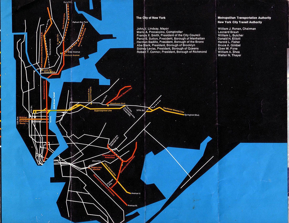
The Nostrand Avenue line was planned to be extended in 1929 as part of the IND Second System. The line would have been extended as a subway to Kings Highway, and then as an elevated line to Avenue S at the cost of $7.4 million. South of Avenue S the line would continue to Voohries Avenue on a four-track structure shared with the proposed Utica Avenue Line for $3.2 million. [12]

In 1939, the IRT Nostrand Avenue Line was planned to be extended to Voorhies Avenue in Sheepshead Bay as a subway to Avenue T and an elevated from there to Voorhies Avenue. [13] In 1946, the New York City Board of Transportation issued a $1 billion plan to extend subway service to the farthest reaches of the outer boroughs, and as part of the plan the line was again projected to extend to Voorhies Avenue. [14]

On September 13, 1951, the Board of Estimate approved a plan put forth by the Board of Transportation that would cost $500 million. As part of the plan the Nostrand Avenue Line was to be extended to Voorhies Avenue in Sheepshead Bay. [15] [16]

In March 1954, the Transit Authority issued a $658 million construction program including the extension of the Nostrand Avenue Line to Avenue U, which would have cost $51.7 million. [17] [18]

The Nostrand Avenue Line was once again slated to be extended further south in 1968 as part of the newly created Metropolitan Transportation Authority's Program for Action. This was to have been several extensions to serve the then-burgeoning areas of Mill Basin and Spring Creek. [19] The Rogers Junction on the IRT Eastern Parkway Line was a serious traffic bottleneck during the rush hours due to the IRT Nostrand Avenue Line tracks' at-grade junctions with the bi-level IRT Eastern Parkway Line. [19] [20] [21] The Rogers Junction would have to be reconstructed with flying junctions to increase capacity for several extensions. The initial plan had the IRT Nostrand Avenue Line would be extended past Flatbush Avenue – Brooklyn College along Flatbush Avenue to a new modern terminal at Avenue U at Kings Plaza. This extension was projected to cost $60 million. Other plans had the line extended along Nostrand Avenue from Avenue H, where the exiting tunnel ends, to Sheepshead Bay at Avenue W or Voorhies Avenue; [19] [20] [22] [23] this second plan had been proposed as part of the line's original construction. [24] The Nostrand Avenue plan, Route 29–C, which was approved by the Board of Estimate on June 3, 1969, would have had three stations added at Kings Highway, Avenue R, and Avenue W, with a storage yard constructed south of Avenue W. [22] [23] [24] [25] [26] [27] [28] The construction of either extension would have reduced delays and improved operational efficiency because Flatbush Avenue would not need to be a terminal any longer. [19]

In the summer of 1972, the IRT Nostrand Avenue Line extension to Avenue W was being designed. [20] [24] By November 1974, the MTA projected that by 1993, the Nostrand Avenue extension would be open. [20] Due to the 1975–76 fiscal crisis that affected the city, most of the remaining projects did not have funding, so they were declined. Expected to be completed by the mid-1970s and early 1980s, [29] [30] lines for the Program for Action had to be reduced or canceled altogether due to the 1970s fiscal crisis. [24]

In 1968, and again in 1989, the MTA gave consideration to extending the Nostrand Avenue Line approximately 1,000 feet (300 m) beyond the Flatbush Avenue station to provide room for turnaround facilities to eliminate the operational restrictions caused by the current layout. [31]

In October 2008, the Regional Plan Association in the report Tomorrow's Transit suggested that the Nostrand Avenue Line be extended two stops to Kings Highway as a way to improve travel times and reliability for subway service on the Brooklyn IRT. [32]

In August 2016, it was reported that the MTA was looking into an extension of the IRT Nostrand Avenue Line along Flatbush Avenue to Marine Park, which would allow trains to serve Kings Plaza. [33]

Extent and service

All services serve the entire line and make all stops.

 Time period
weekdays until 8:45 pmevenings, weekends, and late nights
NYCS-bull-trans-2-Std.svg service
NYCS-bull-trans-5-Std.svg serviceno service

Route description

The two tracks split off from the local tracks of the IRT Eastern Parkway Line and diverge away in the vicinity of Rogers Avenue at the Rogers Avenue Junction, turning south onto Nostrand Avenue to/from the Nostrand Avenue Line. Running beneath Nostrand Avenue, the line serves the neighborhoods of southern Crown Heights, Prospect Lefferts Gardens, Flatbush, East Flatbush, and the Brooklyn College area. The line's final station is Flatbush Avenue–Brooklyn College, where there is an unusual terminal setup. It is the only terminal station in the subway system at the end of a physical line that does not have an island platform, and it was built with two side platforms and two tracks to allow for a planned, but not carried out extension of the IRT Nostrand Avenue Line south towards Voorhies Avenue in Sheepshead Bay. [34] The platforms are connected at the south end just past the bumper blocks (forming a "U" shape), mitigating what is otherwise an inefficient terminal design. This terminal setup is inefficient, and combined with the Rogers Avenue Junction's also-inefficient design (see below), this limits capacity on the line. Therefore, some rush hour 2 and 5 trains run via the IRT New Lots Line. [35] [36]

The IRT Nostrand Avenue Line tunnels continue beyond the bumper blocks at Flatbush Avenue and Nostrand Avenue. They extend for several hundred feet to Avenue H. [37] Up until about 2006, you could see the cemented over gratings extending down Nostrand Avenue. When a new building went up, the grates were removed. Prior to the building of the exit at the south end of the station, there was only a temporary wooden ramp connecting the platforms and the tunnels were actually visible to passengers. [38] [39]

Another factor limiting capacity on the line is the set up of the Rogers Avenue Junction, where trains can diverge from the IRT Eastern Parkway Line to the IRT Nostrand Avenue Line or continue on Eastern Parkway. Rogers Avenue Junction was built when the Nostrand Avenue Line was built, and it only connected the IRT Eastern Parkway Line local tracks to the Nostrand Avenue Line. From west to east between the Franklin Avenue station and the junction, the northbound local track descends to a lower level directly below the southbound local track. Then, the northbound express track, which is still on the upper level at this point, descends to the lower level directly below the southbound express track, creating a dual level two-over-two track layout. [40]

At the junction, a switch on the upper level allows southbound 5 express trains to change to the local track, and a corresponding switch on the lower level allows 5 trains on the northbound local track to change to the express track. Directly to the east, all of the mainline tracks shift slightly to the north, and the Nostrand Avenue Line splits from the local tracks and head south. There is a closed tower at the south end of the southbound platform at the Franklin Avenue station. [40]

This junction is a severe traffic bottleneck during rush hours, and rebuilding it would require massive construction including the tearing up of Eastern Parkway. [41] In 1968, as part of the Program for Action, a rebuilding of the junction was planned in order to alleviate congestion. [19] However, financial troubles caused the plan to be dropped. [42]

Station listing

Station service legend
NYCS-SSI-alltimes.svg Stops all times
NYCS-SSI-weekdaysonly.svg Stops weekdays during the day
Time period details
Wheelchair symbol.svg Station is compliant with the Americans with Disabilities Act
Wheelchair symbol.svg  Station is compliant with the Americans with Disabilities Act
in the indicated direction only
Wheelchair symbol.svg  
Aiga elevator.svg Elevator access to mezzanine only
Neighborhood
(approximate)
Wheelchair symbol.svg StationServicesOpenedTransfers and notes
Crown Heights Begins as split from IRT Eastern Parkway Line local tracks ( 2   NYCS-SSI-alltimes.svg 5   NYCS-SSI-weekdaysonly.svg )
President Street–Medgar Evers College 2   NYCS-SSI-alltimes.svg 5   NYCS-SSI-weekdaysonly.svg August 23, 1920 [2]
Prospect Lefferts Gardens Sterling Street 2   NYCS-SSI-alltimes.svg 5   NYCS-SSI-weekdaysonly.svg August 23, 1920 [2] B44 Select Bus Service
Winthrop Street 2   NYCS-SSI-alltimes.svg 5   NYCS-SSI-weekdaysonly.svg August 23, 1920 [2] B44 Select Bus Service
East Flatbush Wheelchair symbol.svg Church Avenue 2   NYCS-SSI-alltimes.svg 5   NYCS-SSI-weekdaysonly.svg August 23, 1920 [2] B44 Select Bus Service
Beverly Road 2   NYCS-SSI-alltimes.svg 5   NYCS-SSI-weekdaysonly.svg August 23, 1920 [2]
Newkirk Avenue–Little Haiti 2   NYCS-SSI-alltimes.svg 5   NYCS-SSI-weekdaysonly.svg August 23, 1920 [2] B44 Select Bus Service
Wheelchair symbol.svg Flatbush Avenue–Brooklyn College 2   NYCS-SSI-alltimes.svg 5   NYCS-SSI-weekdaysonly.svg August 23, 1920 [2] B44 Select Bus Service
Provision for future expansion

Related Research Articles

<span class="mw-page-title-main">Proposed expansion of the New York City Subway</span>

Since the opening of the original New York City Subway line in 1904, and throughout the subway's history, various official and planning agencies have proposed numerous extensions to the subway system. The first major expansion of the subway system was the Dual Contracts, a set of agreements between the City of New York and the IRT and the BRT. The system was expanded into the outer reaches of the Bronx, Brooklyn, and Queens, and it provided for the construction of important lines in Manhattan. This one expansion of the system provided for a majority of today's system.

<span class="mw-page-title-main">Dual Contracts</span> Transit contracts in New York City

The Dual Contracts, also known as the Dual Subway System, were contracts for the construction and/or rehabilitation and operation of rapid transit lines in the City of New York. The contracts were signed on March 19, 1913, by the Interborough Rapid Transit Company and the Brooklyn Rapid Transit Company. As part of the Dual Contracts, the IRT and BRT would build or upgrade several subway lines in New York City, then operate them for 49 years.

<span class="mw-page-title-main">Bergen Street station (IRT Eastern Parkway Line)</span> New York City Subway station in Brooklyn

The Bergen Street station is a local station on the IRT Eastern Parkway Line of the New York City Subway, located at Bergen Street and Flatbush Avenue in Park Slope, Brooklyn. It is served by the 2 train at all times, the 3 train at all times except late nights, and the 4 train during late nights.

<span class="mw-page-title-main">Grand Army Plaza station</span> New York City Subway station in Brooklyn

The Grand Army Plaza station is a local station on the IRT Eastern Parkway Line of the New York City Subway. It is located in Park Slope, Brooklyn, underneath Flatbush Avenue at its intersection with Plaza Street West and St. Johns Place, on the northwest side of Grand Army Plaza. It is served by the 2 train at all times, the 3 train at all times except late nights, and the 4 train during late nights.

<span class="mw-page-title-main">Eastern Parkway–Brooklyn Museum station</span> New York City Subway station in Brooklyn

The Eastern Parkway–Brooklyn Museum station is a local station on the IRT Eastern Parkway Line of the New York City Subway. Located at the intersection of Washington Avenue and Eastern Parkway in Brooklyn adjacent to the Brooklyn Museum, it is served by the 2 train at all times, the 3 train at all times except late nights, and the 4 train during late nights.

<span class="mw-page-title-main">Nostrand Avenue station (IRT Eastern Parkway Line)</span> New York City Subway station in Brooklyn

The Nostrand Avenue station is a local station on the IRT Eastern Parkway Line of the New York City Subway. Located at the intersection of Nostrand Avenue and Eastern Parkway in Crown Heights, Brooklyn, it is served by the 3 train at all times except late nights and the 4 train during late nights. There is also limited rush hour 2 and 5 services here.

<span class="mw-page-title-main">Kingston Avenue station</span> New York City Subway station in Brooklyn

The Kingston Avenue station is a local station on the IRT Eastern Parkway Line of the New York City Subway. Located at the intersection of Kingston Avenue and Eastern Parkway in Crown Heights, Brooklyn, it is served by the 3 train at all times except late nights and the 4 train during late nights. There is also limited rush hour 2 and 5 service here.

<span class="mw-page-title-main">Crown Heights–Utica Avenue station</span> New York City Subway station in Brooklyn

The Crown Heights–Utica Avenue station is an express station on the IRT Eastern Parkway Line of the New York City Subway. Located under Eastern Parkway near Utica Avenue in Crown Heights, Brooklyn, it is served by the 4 train at all times and the 3 train at all times except late nights. There is also limited rush hour 2 and 5 services here.

<span class="mw-page-title-main">President Street–Medgar Evers College station</span> New York City Subway station in Brooklyn

The President Street–Medgar Evers College station is a station on the IRT Nostrand Avenue Line of the New York City Subway. Located at the intersection of President Street and Nostrand Avenue in Brooklyn, the station is served by the 2 train at all times and the 5 train on weekdays.

<span class="mw-page-title-main">Sterling Street station</span> New York City Subway station in Brooklyn

The Sterling Street station is a station on the IRT Nostrand Avenue Line of the New York City Subway. Located in Prospect Lefferts Gardens, Brooklyn at the intersection of Sterling Street and Nostrand Avenue, the station is served by the 2 train at all times and the 5 train on weekdays.

<span class="mw-page-title-main">Winthrop Street station</span> New York City Subway station in Brooklyn

The Winthrop Street station is a station on the IRT Nostrand Avenue Line of the New York City Subway, located in Brooklyn at the intersection of Winthrop Street and Nostrand Avenue. The station is served by the 2 train at all times and the 5 train on weekdays.

<span class="mw-page-title-main">Beverly Road station</span> New York City Subway station in Brooklyn

The Beverly Road station is a station on the IRT Nostrand Avenue Line of the New York City Subway. It is located at the intersection of Beverley Road and Nostrand Avenue straddling the East Flatbush and Flatbush communities. The station is served by the 2 train at all times and the 5 train on weekdays.

<span class="mw-page-title-main">Newkirk Avenue–Little Haiti station</span> New York City Subway station in Brooklyn

The Newkirk Avenue–Little Haiti station is a station on the IRT Nostrand Avenue Line of the New York City Subway. Located at the intersection of Newkirk and Nostrand Avenues in Brooklyn, the station is served by the 2 train at all times and the 5 train on weekdays.

<span class="mw-page-title-main">Flatbush Avenue–Brooklyn College station</span> New York City Subway station in Brooklyn

The Flatbush Avenue–Brooklyn College station is the southern terminal station on the IRT Nostrand Avenue Line of the New York City Subway. It is located at the intersection of Flatbush and Nostrand Avenues in Flatbush, Brooklyn, locally called "The Junction". The station is served by the 2 train at all times and the 5 train on weekdays. It is also the closest subway station to Brooklyn College and Midwood High School.

<span class="mw-page-title-main">Seventh Avenue station (BMT Brighton Line)</span> New York City Subway station in Brooklyn

The Seventh Avenue station is a station on the BMT Brighton Line of the New York City Subway, located at the intersection of Seventh Avenue, Park Place and Flatbush Avenue in Park Slope and Prospect Heights, Brooklyn. The station is served by the Q train at all times and by the B train on weekdays only.

<span class="mw-page-title-main">Church Avenue station (IRT Nostrand Avenue Line)</span> New York City Subway station in Brooklyn

The Church Avenue station is a station on the IRT Nostrand Avenue Line of the New York City Subway. Located at the intersection of Church and Nostrand Avenues straddling the East Flatbush and Flatbush communities. The station is served by the 2 train at all times and the 5 train on weekdays.

<span class="mw-page-title-main">Franklin Avenue/Botanic Garden station</span> New York City Subway station complex in Brooklyn

The Franklin Avenue/Botanic Garden station is a New York City Subway station complex shared by the IRT Eastern Parkway Line and the BMT Franklin Avenue Line. Located at the intersection of Franklin Avenue and Eastern Parkway in Brooklyn, the complex consists of two distinct stations, connected by a passageway within fare control, and is named for its proximity to the Brooklyn Botanic Garden. The Eastern Parkway Line station is served by the 2 and 4 trains at all times, the 3 train at all times except late nights, and the 5 train on weekdays only. The Franklin Avenue Line station is served by Franklin Avenue Shuttle (S) at all times.

<span class="mw-page-title-main">Utica Avenue</span> Avenue in Brooklyn, New York

Utica Avenue is a major avenue in Brooklyn, New York City, New York, United States. It is one of several named for the city of Utica in Upstate New York. It runs north–south and occupies the position of East 50th Street in the Brooklyn street grid, with East 49th Street to its west and East 51st Street to its east for most of its path. The south end of Utica Avenue is at Flatbush Avenue; its north end is at Fulton Street, beyond which it is continued by Malcolm X Boulevard in Bedford–Stuyvesant. Malcolm X Boulevard continues to Broadway, where it terminates on Broadway between Lawton Street and Hart Street.

The IRT Eastern Parkway Line is one of the lines of the A Division of the New York City Subway. Built for the Interborough Rapid Transit Company (IRT), it stretches from Downtown Brooklyn south along Flatbush Avenue and east along Eastern Parkway to Crown Heights. After passing Utica Avenue, the line rises onto an elevated structure and becomes the New Lots Line to the end at New Lots Avenue in East New York, Brooklyn. The west end of the Eastern Parkway Line is at the Joralemon Street Tunnel under the East River.

References

  1. "Annual Subway Ridership (2017–2022)". Metropolitan Transportation Authority. 2022. Retrieved November 8, 2023.
  2. 1 2 3 4 5 6 7 8 9 "Brooklyn Tube Extensions Open: I.R.T. Begins Service on Eastern Parkway and Nostrand Avenue Lines" (PDF). New York Times. August 23, 1920. Retrieved February 28, 2010.
  3. "Terms and Conditions of Dual System Contracts". nycsubway.org. Retrieved February 16, 2015.
  4. "The Dual System of Rapid Transit (1912)". nycsubway.org.
  5. 1 2 "Most Recent Map of the Dual Subway System WhIch Shows How Brooklyn Borough Is Favored In New Transit Lines". Brooklyn Daily Eagle. September 9, 1917. Retrieved August 23, 2016 via Brooklyn Newspapers.
  6. "For Nostrand Ave. Subway. Flatbush Committee Will Try to Wake Up the Public Service Commission". Brooklyn Daily Eagle. May 27, 1910. Retrieved August 23, 2016 via Brooklyn Newspapers.
  7. "Big Eastern Parkway Deal". Brooklyn Daily Eagle. July 1, 1915. Retrieved August 23, 2016 via Brooklyn Newspapers.
  8. "More Interborough Service for Brooklyn 2 New Lines". pudl.princeton.edu. Interborough Rapid Transit Company. August 23, 1920. Retrieved September 19, 2016.
  9. "Transit Outlook Bright in Brooklyn - First Branch Lines on Assessment Plan Likely to be Built in That Borough". The New York Times. March 6, 1910. ISSN   0362-4331 . Retrieved August 9, 2016.
  10. Proceedings of the New York State Public Service Commission, First District State of New York Volume VXII, From July 1 to December 31, 1918 (With Index). New York State Public Service Commission. 1918. p. 1806.
  11. "Nostrand Ave Tube Extension to C.I. Decided on by P.S.C. Manhattan and Brighton Beaches to Be Connected With Interborough Subway System". Brooklyn Daily Eagle. January 19, 1919. Retrieved August 23, 2016 via Brooklyn Newspapers.
  12. "100 MILES OF SUBWAY IN NEW CITY PROJECT; 52 OF THEM IN QUEENS" (PDF). The New York Times. September 16, 1929. Retrieved January 16, 2018.
  13. nycsubway.org—History of the Independent Subway
  14. "Borough Subway Relief Still 2 to 3 Years Off". Brooklyn Daily Eagle. Newspapers.com. December 6, 1946. pp.  1, 5.
  15. Crowell, Paul (September 14, 1951). "$500,000,000 Voted For 2d Ave. Subway By Estimate Board: Program Including Connections to Existing Lines Depends on Public's Exemption of Bonds: Offer to L.I.R.R. Backed: Authorization Comes After Quill Admits That He Cannot Support 'Steal' Charge" (PDF). The New York Times. Retrieved January 25, 2016.
  16. "Board of Transportation - 1951". Thejoekorner.com. Archived from the original on February 24, 2021. Retrieved March 25, 2014.
  17. "Assurance of Nostrand Avenue Spur Is a Great Victory for Brooklyn". Brooklyn Daily Eagle. Newspapers.com. January 17, 1954. Retrieved August 19, 2015.
  18. "Improvements That Are Planned for Subways" (PDF). The New York Times. March 24, 1954. Retrieved February 8, 2016.
  19. 1 2 3 4 5 "Full text of "Metropolitan transportation, a program for action. Report to Nelson A. Rockefeller, Governor of New York."". Internet Archive. November 7, 1967. Retrieved October 1, 2015.
  20. 1 2 3 4 Feinman, Mark. "The New York Transit Authority in the 1970s". nycsubway.org. Retrieved April 23, 2015.
  21. "www.nycsubway.org: New York City Subway Track Maps". www.nycsubway.org. October 9, 2015. Retrieved October 9, 2015.
  22. 1 2 "Regional Transportation Program". Metropolitan Transportation Authority. 1969. Retrieved July 26, 2016.
  23. 1 2 King, Seth S. (September 21, 1968). "City Approves 2d Ave. Subway And 11 Other New Transit Lines; A 2D Ave Subway Approved by City". The New York Times . Retrieved October 3, 2015.
  24. 1 2 3 4 Raskin, Joseph B. (2013). The Routes Not Taken: A Trip Through New York City's Unbuilt Subway System. New York, New York: Fordham University Press. doi:10.5422/fordham/9780823253692.001.0001. ISBN   978-0-82325-369-2.
  25. Erlitz, Jeffrey (June 2004). "Tech Talk". New York Division Bulletin. Electric Railroader's Association. 47 (6): 8–9. Retrieved July 26, 2016.
  26. "1968 NYCTA Expansion Plans (Picture)". Second Avenue Sagas. Retrieved September 14, 2016.
  27. "A Record $250-Million Is Asked for Transit Expansion Here" (PDF). The New York Times . November 5, 1968. Retrieved October 2, 2015.
  28. Prial, Frank J. (October 31, 1971). "Brooklyn Bemoans Its Ancient Subways" (PDF). The New York Times . Retrieved September 16, 2015.
  29. "New Line May Get Double Trackage: Transit Unit Shift on Queens Super-Express" (PDF). The New York Times . February 21, 1971. Retrieved September 26, 2015.
  30. Burks, Edward C. (October 24, 1973). "Work Begun on Queens Subway Extension" (PDF). The New York Times . Retrieved September 26, 2015.
  31. Feinman, Mark S. "The New York Transit Authority in the 1980s". nycsubway.org. Retrieved September 16, 2012.
  32. "Tomorrow's Transit New Mobility for the Region's Urban Core" (PDF). rpa.org. Regional Plan Association. October 2008. Retrieved August 23, 2016.
  33. "MTA looks into possible new subway line to Marine Park". news12.com. News 12 Brooklyn. August 8, 2016. Archived from the original on August 12, 2016. Retrieved August 9, 2016.
  34. "Station: Flatbush Avenue (IRT Brooklyn Line)". nycsubway.org. Retrieved September 17, 2012.
  35. "2Subway Timetable, Effective June 26, 2022". Metropolitan Transportation Authority . Retrieved August 26, 2023.
  36. "5Subway Timetable, Effective June 26, 2022". Metropolitan Transportation Authority . Retrieved August 26, 2023.
  37. "Number One Transportation Progress An Interim Report". thejoekorner.com. Metropolitan Transportation Authority. December 1968. Retrieved August 19, 2016.
  38. Fischler, Stan (January 1, 2000). The Subway: A Trip Through Time on New York's Rapid Transit. H & M Productions. p. 163. ISBN   9781882608232.
  39. "A history of futility for Utica, Nostrand extension plans". Second Ave. Sagas. September 7, 2010. Retrieved April 26, 2016.
  40. 1 2 "www.nycsubway.org: New York City Subway Track Maps". www.nycsubway.org. October 9, 2015. Retrieved October 9, 2015.
  41. "Tomorrow's Transit New Mobility for the Region's Urban Core" (PDF). rpa.org. Regional Plan Association. October 2008. Retrieved August 15, 2016.
  42. "www.nycsubway.org".
Template:Attached KML/IRT Nostrand Avenue Line
KML is from Wikidata