Bay Ridge Branch

Last updated

Bay Ridge Branch
Bay Ridge Branch 14th Av jeh.JPG
Looking west from 14th Avenue in Borough Park, Brooklyn
Overview
StatusActive
Owner Long Island Rail Road
Locale Brooklyn and Queens, New York City
Termini
Stations17 (all former)
Service
Type Freight
System Long Island Rail Road
Operator(s) New York and Atlantic Railway
History
Opened1876 (1876) [1]
Completed1883 (1883) [2]
Passenger service ended1924 (1924) [3]
Electrification installed1927 (1927) [4]
Electrification removed1968 (1968)
Technical
Number of tracks1–4
Track gauge 4 ft 8+12 in (1,435 mm) standard gauge
Route map

Contents

BSicon CONTg.svg
BSicon uKACCa.svg
BSicon STR.svg
BSicon dCONTgq.svg
BSicon umKRZo.svg
BSicon cSTRq.svg
BSicon dKRZo.svg
BSicon ABZq+lr.svg
BSicon cSTRq.svg
BSicon dCONTfq.svg
BSicon uSTR.svg
BSicon SHI3g+l.svg
BSicon vSHI3r-.svg
BSicon uCONTf.svg
BSicon STR.svg
BSicon eHST.svg
BSicon eHST.svg
Cypress Avenue
BSicon dSTR.svg
BSicon utdCONTg.svg
BSicon exCONTgq.svg
BSicon edABZg+r.svg
BSicon utdSTR.svg
BSicon edHST.svg
BSicon utdSTRe.svg
Cooper Avenue Junction
BSicon dGRZq.svg
BSicon dGRZq.svg
BSicon dSTR.svg
BSicon dGRZq.svg
BSicon udSTR.svg
BSicon dSTR.svg
BSicon udHST.svg
Wilson Avenue
BSicon tdSTRa.svg
BSicon utdSTRa.svg
East New York Tunnels
BSicon etdHST.svg
BSicon utdHST.svg
Bushwick Avenue–Aberdeen Street
BSicon uCONTgq.svg
BSicon udSTRq.svg
BSicon tdSTR.svg
BSicon udKRZu.svg
BSicon uCONTfq.svg
BSicon tdSTR.svg
BSicon udHST.svg
Broadway Junction
BSicon utCONTgq.svg
BSicon utdSTRq.svg
BSicon tdSTR.svg
BSicon utdSTRq.svg
BSicon udSTR.svg
BSicon utCONTfq.svg
BSicon CONTgq.svg
BSicon dHSTq.svg
BSicon tdSTR.svg
BSicon umdKRZo.svg
BSicon CONTfq.svg
BSicon tdSTRe.svg
BSicon udHST.svg
Atlantic Avenue
BSicon dSTR.svg
BSicon udHST.svg
Sutter Avenue
BSicon dSTR.svg
BSicon udHST.svg
Livonia Avenue
BSicon uCONTgq.svg
BSicon udABZq+r.svg
BSicon mdKRZu.svg
BSicon udKRZu.svg
BSicon uCONTfq.svg
BSicon uSTR~L.svg
BSicon STR.svg
BSicon lMKRZ3+1u.svg
BSicon uSTR3h+1h.svg
BSicon uSTR~L.svg
BSicon uSTR~R.svg
BSicon uSTR~R.svg
BSicon udSTR.svg
BSicon vUSTxr.svg
BSicon udSTR.svg
BSicon udSTR.svg
BSicon edHST.svg
BSicon udHST.svg
New Lots Avenue
BSicon dRP4q.svg
BSicon udSKRZ-G4hl.svg
BSicon dSKRZ-G4h.svg
BSicon udSKRZ-G4hr.svg
BSicon dRP4q.svg
BSicon udSTR.svg
BSicon dSTR.svg
BSicon udCONTf.svg
BSicon udKDSTe.svg
BSicon dDST.svg
Linden Shops
BSicon eHST.svg
Rugby
BSicon eHST.svg
Kouwenhoven
BSicon eHST.svg
Vanderveer Park
BSicon eHST.svg
Kings County Central Junction
BSicon eHST.svg
Ocean Avenue
BSicon uCONTgq.svg
BSicon ehHSTae.svg
BSicon uSTRq.svg
BSicon uCONTfq.svg
BSicon dRP4q.svg
BSicon hSKRZ-G4hu.svg
BSicon dRP4q.svg
BSicon uCONTgq.svg
BSicon ehHSTae.svg
BSicon uSTRq.svg
BSicon uCONTfq.svg
BSicon STR.svg
BSicon uSTR+l.svg
BSicon udCONTfq.svg
BSicon uCONTgq.svg
BSicon ehHSTae.svg
BSicon uSTRq.svg
BSicon uehHSTae.svg
BSicon uSTRq.svg
BSicon udCONTfq.svg
BSicon STR.svg
BSicon uHST.svg
BSicon uSTRc2.svg
BSicon STR.svg
BSicon uHST3.svg
BSicon utSTRc2.svg
BSicon utUWu3.svg
BSicon mKRZ3+1u.svg
BSicon uSTRc4.svg
BSicon utdCONTgq.svg
BSicon utABZq1.svg
BSicon utSTRc4.svg
BSicon mKRZt.svg
BSicon utCONTfq.svg
BSicon dRP4q.svg
BSicon hSKRZ-G4haeo.svg
BSicon dRP4q.svg
BSicon exlHST.svg
BSicon TUNNEL1.svg
Third Avenue
BSicon CONTgq.svg
BSicon ABZgr.svg
BSicon eHST.svg
Bay Ridge
BSicon YRD.svg
65th Street Yard
BSicon WASSERq.svg
BSicon MASKc.svg
BSicon WASSERq.svg
BSicon BOOT.svg
BSicon STR.svg
BSicon WASSERq.svg
NYNJ car floats
across Hudson River
BSicon YRD.svg
BSicon lCONTf@G.svg

The Bay Ridge Branch is a rail line owned by the Long Island Rail Road (LIRR) and operated by the New York and Atlantic Railway in New York City. It is the longest freight-only line of the LIRR, connecting the Montauk Branch and CSX Transportation's Fremont Secondary (to the Hell Gate Bridge) at Glendale, Queens with the Upper New York Bay at Bay Ridge, Brooklyn.

Car float service provided by New York New Jersey Rail operates between Greenville Yard at Greenville, Jersey City and the 65th Street Yard at the Bay Ridge end of the line. [5]

History

Early history

The first part of the line was opened by the New York, Bay Ridge and Jamaica Railroad in 1876, from Bay Ridge to the crossing of the Brooklyn, Bath and Coney Island Railroad near New Utrecht. [1]

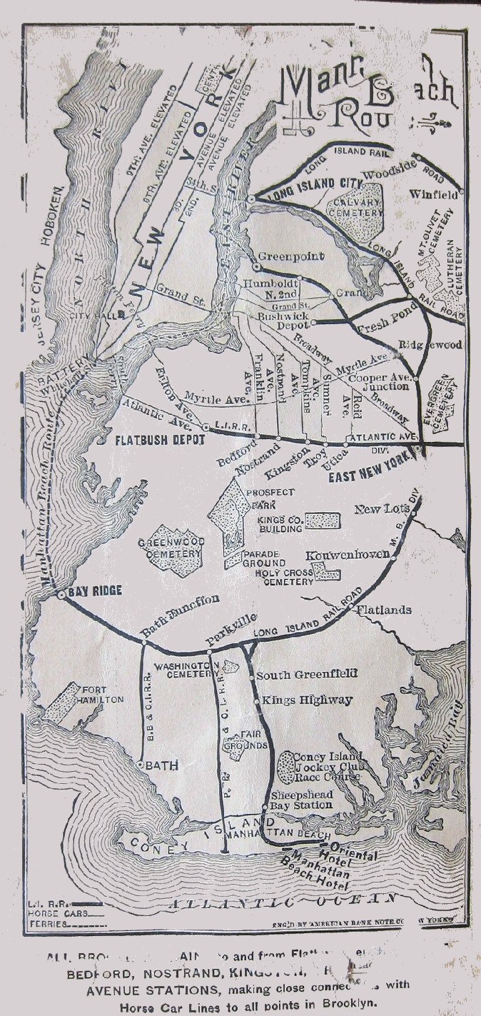
An extension from New Utrecht east and northeast to New Lots opened in 1877, and at the same time the New York and Manhattan Beach Railway opened the line from New Lots north to East New York. [6] An extension north from East New York to Cooper Avenue (and then northwest to Greenpoint, later the Evergreen Branch) opened in 1878, [7] and the Long Island City and Manhattan Beach Railroad (incorporated February 24, 1883, merged with the New York and Manhattan Beach and New York, Bay Ridge and Jamaica into the New York, Brooklyn and Manhattan Beach Railway August 27, 1885) built from Cooper Avenue north to the Montauk Branch at Glendale in 1883. [2]

Decline

Passenger service on the line ended in 1924. [3] The entire line was electrified, starting on July 8, 1927, for New York, New Haven and Hartford Railroad freight trains coming off the New York Connecting Railroad (Hell Gate Bridge). [4] Electric operation ended on December 31, 1968. [8]

Recent years

On June 4, 1999, Mayor Rudy Giuliani announced that New York City reached an agreement to open and operate the 65th Street Yard with the New York and Atlantic Railway, which would use it as an intermodal facility to expand its customer base. The takeover of Conrail by Norfolk Southern Railway and CSX Transportation was expected to significantly increase rail freight movement into New York City. The yard was completely renovated by the New York City Economic Development Corporation. The NYCEDC also began work on a two-year Cross Harbor Freight Movement Study to evaluate options for a freight tunnel. [9]

BR LIRR E fr 5 Av jeh.JPG
Triple track sharing an open cut with BMT Sea Beach Line (left)
Bay Ridge Branch Ralph Ave jeh.JPG
Crossing Ralph Avenue

Proposals

A proposed Cross-Harbor Rail Tunnel from New Jersey to Brooklyn would use the Bay Ridge Branch to reach the rest of Long Island, with the line upgraded to double-stack clearances. The state is conducting an environmental review of the project. [10]

Another proposal would have the New York City Subway use the tracks to link Brooklyn, Queens, and the Bronx via the Hell Gate Bridge. [11] In 1996 the Regional Plan Association conducted a study to determine the feasibility of the rail link. [12] Based on Paris's RER commuter rail system, the Triboro RX proposal would create a loop around the city. It was first proposed by the Regional Plan Association in 1996. The proposed line, discussion of which was revived in 2012, would connect to all non-shuttle subway services. [13] Obstacles for the proposal include the proposed Cross-Harbor Rail Tunnel, the lack of electrification on the line, and the single-tracking in some parts of the line. Additionally, there is debate on where the line's northern terminus would be: some, including MoveNY, [14] call for it to end at Hunts Point, [11] while others suggest it end at Yankee Stadium. [13]

Interborough Express

In mid-October 2019, the MTA announced that it would study the feasibility of restoring passenger service on the Bay Ridge Branch between Bay Ridge and Astoria, a portion of the proposed Triboro RX route. [15] On January 23, 2020, the MTA Board awarded a $1.3 million contract to study the feasibility of restoring passenger service to this section to AECOM. [16] In November 2021, Acting MTA Chairman and CEO Janno Lieber said that money from Infrastructure Investment and Jobs Act could be used to fund the completion of the Bay Ridge Branch project. [17]

In early January 2022, as part of her State of the State address, New York governor Kathy Hochul announced that the state would move forward with the Bay Ridge Branch Line by conducting an environmental study on the Interborough Express, a 14-mile (23 km) corridor using the existing Bay Ridge Branch from Bay Ridge, Brooklyn, to Jackson Heights, Queens. [18] The study would consider whether the line should be heavy rail (rapid transit or regional rail), light rail, or bus rapid transit. [19] [20] End-to-end travel times are expected to be 40 minutes, and weekday ridership is initially projected to be 74,000 to 88,000. The route would connect up to 17 subway lines and the Long Island Rail Road. A feasibility study was also completed on January 20, 2022. [21] [22] [23] Governor Hochul also announced that she had directed the Port Authority of New York and New Jersey to complete an environmental review for the Cross-Harbor Rail Tunnel for freight. [24] Hochul announced in her January 2023 address that the project would proceed as a light rail corridor. [25] Reasons for the light rail choice include faster service, easier construction—mostly fitting in existing right of way with a short on street segment, availability of off-the-shelf rolling stock and a lower overall cost, estimated at $5.5 billion, or about $48,000 per expected daily rider. The proposed headway is 5 minutes during peak hours and 10 minutes at other times. Freight use would continue, requiring separated tracks. [10]

Former stations

The following passenger stations once existed on the line: [26]

StationDate openedDate closedNotes
Bay Ridge1893May 14, 1924Connection to 65th Street Yard
Third AvenueJune 2, 1883May 14, 1924
Brooklyn, Bath and Coney Island Railroad CrossingJune 2, 18831894Crossing with the Brooklyn, Bath and Coney Island Railroad
ParkvilleJune 2, 18831884Connection to the Prospect Park and Coney Island Railroad [27]
Manhattan Beach Junction18841915Former junction with the Manhattan Beach Branch
Ocean AvenueJuly 18, 1877May 14, 1924
Kings County Central JunctionJune 29, 1878late 1878
Vanderveer Park1878May 14, 1924Originally named Flatlands
KouwenhovenJuly 18, 1877May 14, 1924
Rugby1888May 14, 1924Originally named Ford's Corners
New Lots RoadJuly 18, 18771897
East New York July 18, 1877May 14, 1924Junction with Atlantic Branch, originally named Manhattan Crossing
Fulton Street1914May 14, 1924
Bushwick AvenueJuly 18, 1877May 14, 1924Originally Central Avenue
Central AvenueJune 2, 18831884
Cooper Avenue JunctionJune 2, 18831894Junction with Evergreen Branch
Cypress Avenue1888May 14, 1924Originally named Dummy Crossing, then Ridgewood
Myrtle Avenue1893May 14, 1924At the intersection with Fresh Pond Road, track continues north as the New York Connecting Railroad and connects west/east to the Lower Montauk Branch
Fresh Pond 18691998 [28] Originally named Bushwick Junction (Lower Montauk Branch)

See also

Related Research Articles

<span class="mw-page-title-main">Long Island Rail Road</span> Commuter rail system on Long Island, New York

The Long Island Rail Road, often abbreviated as the LIRR, is a commuter rail system in the southeastern part of the U.S. state of New York, stretching from Manhattan to the eastern tip of Suffolk County on Long Island. With an average weekday ridership of 354,800 passengers in 2016, it is the busiest commuter railroad in North America. It is also one of the world's few commuter systems that runs 24/7 year-round. It is publicly owned by the Metropolitan Transportation Authority, which refers to it as MTA Long Island Rail Road. In 2022, the system had a ridership of 70,342,700, or about 253,800 per weekday as of the second quarter of 2023.

<span class="mw-page-title-main">Proposed expansion of the New York City Subway</span>

Since the opening of the original New York City Subway line in 1904, and throughout the subway's history, various official and planning agencies have proposed numerous extensions to the subway system. The first major expansion of the subway system was the Dual Contracts, a set of agreements between the City of New York and the IRT and the BRT. The system was expanded into the outer reaches of the Bronx, Brooklyn, and Queens, and it provided for the construction of important lines in Manhattan. This one expansion of the system provided for a majority of today's system.

<span class="mw-page-title-main">Brooklyn Rapid Transit Company</span> Former transit holding company in New York City

The Brooklyn Rapid Transit Company (BRT) was a public transit holding company formed in 1896 to acquire and consolidate railway lines in Brooklyn and Queens, New York City, United States. It was a prominent corporation and industry leader using the single-letter symbol B on the New York Stock Exchange.

<span class="mw-page-title-main">New York Connecting Railroad</span> Freight rail line in New York City

The New York Connecting Railroad or NYCR is a rail line in the borough of Queens in New York City. It links New York City and Long Island by rail directly to the North American mainland. Amtrak, CSX, Canadian Pacific Kansas City, Providence and Worcester Railroad and New York and Atlantic Railway (NYAR) currently use the line. It runs from the Hell Gate Bridge over the East River to Fresh Pond Junction yard in Glendale in Queens. It was completed in 1917. Amtrak uses the northernmost section of the line from Sunnyside Junction in the Woodside section of Queens to the Hell Gate Bridge into the Bronx from which it follows the line north to Boston.

<span class="mw-page-title-main">South Brooklyn Railway</span> Railroad in New York City

East Side Access (ESA) is a public works project in New York City that extended the Long Island Rail Road (LIRR) two miles from its Main Line in Queens to the new Grand Central Madison station under Grand Central Terminal on Manhattan's East Side. The Metropolitan Transportation Authority (MTA) project was originally scheduled to open in 2009 but was delayed by more than a decade. The new station and tunnels opened with limited service to Jamaica station in Queens on January 25, 2023, and full service began on February 27, 2023. The estimated cost of the project rose nearly threefold from US$3.5 billion to US$11.1 billion as of April 2018, making it one of the world's most expensive underground rail-construction projects.

The Lower Manhattan–Jamaica/JFK Transportation Project was a proposed public works project in New York City, New York, that would use the Long Island Rail Road's Atlantic Branch and a new tunnel under the East River to connect a new train station near or at the World Trade Center Transportation Hub site with John F. Kennedy International Airport and Jamaica station on the LIRR. It would allow for a one-seat, 36-minute-long ride between JFK Airport and Lower Manhattan, cut commuting times from Long Island by up to 40% and reduce crowding on the IRT Broadway–Seventh Avenue Line, IRT Lexington Avenue Line, IND Eighth Avenue Line, and BMT Broadway Line in Manhattan.

<span class="mw-page-title-main">Montauk Branch</span> Long Island Rail Road branch

The Montauk Branch is a rail line owned and operated by the Long Island Rail Road in the U.S. state of New York. The line runs the length of Long Island, 115 miles (185 km) from Long Island City to Montauk. However, in LIRR maps and schedules for public use, the term Montauk Branch refers to the line east of Babylon; service from Jamaica to Babylon is covered by separate Babylon Branch schedules, while the line west of Jamaica is currently unused for passenger service. A select number of Montauk Branch trains operate via the Main Line during peak hours.

<span class="mw-page-title-main">Long Beach Branch</span> Long Island Rail Road branch

The Long Beach Branch is an electrified rail line and service owned and operated by the Long Island Rail Road in the U.S. state of New York. The branch begins at Valley Interlocking, just east of Valley Stream station, where it merges with the Far Rockaway Branch to continue west as the Atlantic Branch. East from there the Long Beach Branch parallels the Montauk Branch to Lynbrook station, where it turns south toward Long Beach station. Trains operating on the Long Beach Branch continue west of Valley Stream via the Atlantic Branch to Jamaica station, with most continuing on to Grand Central or Penn Station in Midtown Manhattan. In 2018, the branch recorded an annual ridership of 4,849,085 based on ticket sales, down 1% from 2017.

The IND Rockaway Line is a rapid transit line of the IND Division of the New York City Subway, operating in Queens. It branches from the IND Fulton Street Line at Rockaway Boulevard, extending over the Jamaica Bay, into the Rockaways. At its southern end in the Rockaways, the line has two branches: one traveling east to Far Rockaway–Mott Avenue and one traveling west to Rockaway Park–Beach 116th Street. The A train serves the line on the Far Rockaway branch, as well as on the section north of Hammels Wye. The Rockaway Park Shuttle runs between Broad Channel and Rockaway Park. Five rush hour A trains provide service between Rockaway Park and Manhattan in the peak direction.

<span class="mw-page-title-main">Main Line (Long Island Rail Road)</span> Long Island Rail Road branch

The Main Line is a rail line owned and operated by the Long Island Rail Road in the U.S. state of New York. It begins as a two-track line at Long Island City station in Long Island City, Queens, and runs along the middle of Long Island about 95 miles (153 km) to Greenport station in Greenport, Suffolk County. At Harold Interlocking approximately one mile east of Long Island City, the tracks from the East River Tunnels and 63rd Street Tunnel into Manhattan intersect with the Main Line, which most trains use rather than continuing to Long Island City station.

The Long Island Rail Road is a railroad owned by the Metropolitan Transportation Authority in the U.S. state of New York. It is the oldest United States railroad still operating under its original name and charter. It consolidated several other companies in the late 19th century. The Pennsylvania Railroad owned the Long Island Rail Road for the majority of the 20th century and sold it to the State in 1966.

<span class="mw-page-title-main">Rockaway Beach Branch</span> Former Long Island Rail Road branch (closed 1962)

The Rockaway Beach Branch was a rail line owned and operated by the Long Island Rail Road in Queens, New York City, United States. The line left the Main Line at Whitepot Junction in Rego Park heading south via Ozone Park and across Jamaica Bay to Hammels in the Rockaways, turning west there to a terminal at Rockaway Park. Along the way it connected with the Montauk Branch near Glendale, the Atlantic Branch near Woodhaven, and the Far Rockaway Branch at Hammels.

<span class="mw-page-title-main">Transportation on Long Island</span> Overview of transportation on Long Island

Nearly every major type of transportation serves Long Island, including three major airports, railroads and subways, and several major highways. The New York City Subway only serves the New York City boroughs of Brooklyn and Queens. There are historic and modern bridges, recreational and commuter trails, and ferries, that connect the boroughs of Queens and Brooklyn to Manhattan, the south shore with Fire Island and Long Island's north shore and east end with the state of Connecticut.

<span class="mw-page-title-main">Evergreen Branch</span> Former Long Island Rail Road branch

The Evergreen Branch was a branch of the Long Island Rail Road (LIRR) that ran in Brooklyn and part of Queens in New York City. The line, at its fullest extent, ran between Greenpoint, Brooklyn and Ridgewood, Queens. The line consisted of two leased portions. The first portion, between Greenpoint and Jefferson Street, was leased from the Glendale and East River Railroad. The second portion, from Jefferson Street to Ridgewood, was leased from the Brooklyn and Rockaway Beach Railroad Company, and was known as the Evergreen Branch, a name later extended to the rest of the line.

<span class="mw-page-title-main">Staten Island Tunnel</span> Abandoned and incomplete subway tunnel in New York City

The Staten Island Tunnel is an abandoned, incomplete railway/subway tunnel in New York City. It was intended to connect railways on Staten Island to the BMT Fourth Avenue Line of the New York City Subway, in Brooklyn, via a new crossing under the Narrows. Planned to extend 10,400 feet (3,200 m), the tunnel would have been among the world's longest at the time of its planning, in the late 19th and early 20th centuries.

<span class="mw-page-title-main">AirTrain LaGuardia</span> Unbuilt people mover system at LaGuardia Airport in New York City

AirTrain LaGuardia was a proposed 1.5-mile-long (2.4 km) people mover system and elevated railway in New York City, United States, that would provide service to LaGuardia Airport in Queens. It would have connected with the New York City Subway and Long Island Rail Road (LIRR) in Willets Point, similar to how the existing AirTrain JFK system connects John F. Kennedy International Airport’s six terminals to the LIRR in southern Queens at Jamaica station and to the subway at both Sutphin Boulevard–Archer Avenue–JFK Airport station and Howard Beach-JFK Airport station; and how the existing AirTrain Newark station connects Newark Liberty International Airport’s three terminals to NJ Transit Rail Operations and Amtrak at a dedicated station.

<span class="mw-page-title-main">Program for Action</span> New York City Subway expansion program (1968–1989)

Metropolitan Transportation: A Program for Action, also known as simply the Program for Action, the Grand Design, or the New Routes Program, was a proposal in the mid-1960s for a large expansion of mass transit in New York City, created under then-Mayor John Lindsay. Originally published on February 29, 1968, the Program for Action was one of the most ambitious expansion plans in the history of the New York City Subway. The plan called for 50 miles (80 km) of tracks to be constructed, and more than 80% of the new trackage was to be built in the borough of Queens. The $2.9 billion plan also called for improvements to other modes of mass transit, such as the present-day Long Island Rail Road and Metro-North Railroad commuter rail systems, and further integration between mass transit and the New York City-area airport system.

The Interborough Express (IBX) is a proposed 14-mile (22.5 km) light rail line in New York City. As proposed, the line would use the existing right-of-way from the Bay Ridge Branch and Fremont Secondary to connect Bay Ridge, Brooklyn and Jackson Heights, Queens, but operate on its own separate tracks. Near the All Faiths Cemetery in Queens, IBX would operate on the street. As of 2023 the Metropolitan Transportation Authority (MTA) estimated that the project would be operational in 2027.

References

  1. 1 2 "PRR Chronology, 1876" (PDF). (116  KiB), April 2005 Edition
  2. 1 2 Interstate Commerce Commission, Valuation Report, New York, Brooklyn and Manhattan Beach Archived June 26, 2002, at archive.today
  3. 1 2 "INVENTORY OF DECKING OPPORTUNITIES OVER TRANSPORTATION PROPERTIES Final Report: 6.2: TRANSIT AND RAILROAD OPEN CUTS: BROOKLYN" (PDF). nyc.gov . New York City Department of City Planning. September 2008. Archived from the original (PDF) on March 4, 2016. Retrieved October 25, 2015.
  4. 1 2 "PRR Chronology, 1927" (PDF). (100  KiB), July 2004 Edition
  5. Braden, Dustin (July 6, 2016). "US ports set to receive millions to improve freight fluidity". Journal of Commerce.
  6. "PRR Chronology, 1877" (PDF). (156  KiB), April 2005 Edition
  7. "PRR Chronology, 1878" (PDF). (126  KiB), June 2006 Edition
  8. "LONG DARK ROAD. The Bay Ridge LIRR branch - Forgotten New York". forgotten-ny.com. March 29, 2009. Retrieved November 5, 2018.
  9. "Mayor Announces Agreement With New York & Atlantic Railway To Reactivate Brooklyn Rail Yard". www.nyc.gov (Press release). Mayor's Press Office. June 4, 1999. Retrieved January 9, 2022.
  10. 1 2 Luczak, Marybeth (January 11, 2023). "Light Rail Selected for New York's Interborough Express Project". Railway Age.
  11. 1 2 Wishnia, Steven (August 22, 2013). "How About A Subway Linking Brooklyn, Queens & The Bronx WITHOUT Manhattan?". Gothamist. Archived from the original on August 21, 2013. Retrieved August 22, 2013.
  12. "Third Regional Plan Summary". Regional Plan Association. May 1, 1996. Archived from the original on July 28, 2013.
  13. 1 2 Rubinstein, Dana (April 25, 2012). "The surprising return of the three-borough 'X line' subway". Capital New York. Archived from the original on March 25, 2014. Retrieved March 25, 2014.
  14. MoveNY home page
  15. Rivoli, Dan (October 15, 2019). "Advocates Push to Revive Three Old Rail Lines in City". NY1. Retrieved October 16, 2019.
  16. Offenhartz, Jake (January 23, 2020). "The MTA Is Considering A New Train Line Connecting Bay Ridge To Astoria". Gothamist. Retrieved January 9, 2022.
  17. Levy, Kayla (November 12, 2021). "Federal Money Could Finance Astoria To Brooklyn Train: MTA Brass". Astoria-Long Island City, NY Patch. Retrieved January 9, 2022.
  18. WABC (January 5, 2022). "Proposed transit line would connect Brooklyn, Queens to 17 subway lines, LIRR". ABC7 New York. Retrieved January 6, 2022.
  19. Chung, Jen (January 5, 2022). "Hochul Promises "Inter-Borough Express" Rail Service To Connect Brooklyn And Queens". Gothamist. Retrieved January 6, 2022.
  20. Geberer, Raanan (January 5, 2022). "Hochul's new 'Interborough' proposal would link Brooklyn, Queens with rail service". Brooklyn Eagle. Retrieved January 6, 2022.
  21. Gold, Michael (January 20, 2022). "Transit Line Connecting Brooklyn and Queens Moves Step Closer to Reality". The New York Times. ISSN   0362-4331 . Retrieved January 21, 2022.
  22. Duggan, Kevin (January 20, 2022). "Hochul unveils more details about Interborough Express in new study". amNewYork. Retrieved January 21, 2022.
  23. Interborough Express (IBX)—Feasibility Study and Alternatives Analysis, Interim Report, MTA, January 2022
  24. "Interborough Express". mta.info. Metropolitan Transportation Authority. January 5, 2021. Archived from the original on January 9, 2022. Retrieved January 9, 2022.
  25. Martinez, Jose (January 10, 2023). "Hochul Calls MTA 'Lifeblood' of New York, but Transit Plans Lack Meat". The City. Retrieved January 11, 2023.
  26. "Bay Ridge line". lirrhistory.com. Archived from the original on January 26, 2000.{{cite web}}: CS1 maint: unfit URL (link)
  27. Manhattan Beach Division Timetable; June 1884 (TrainsAreFun)
  28. Sengupta, Somini (March 15, 1998). "End of the Line for L.I.R.R.'s 10 Loneliest Stops". The New York Times. Retrieved December 24, 2007.
Template:Attached KML/Bay Ridge Branch
KML is not from Wikidata