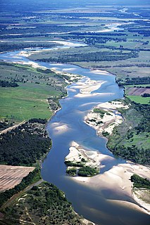
The Sabine River is a river, 510 miles (820 km) long, in the Southern U.S. states of Texas and Louisiana. In its lower course, it forms part of the boundary between the two states and empties into Sabine Lake, an estuary of the Gulf of Mexico. Over the first half of the 19th century, the river formed part of the Spanish–American, Mexican–American, and Texan–American international boundaries. The upper reaches of the river flow through the prairie country of northeast Texas. Along much of its lower reaches, it flows through the pine forests along the Texas–Louisiana border, and the bayou country near the Gulf Coast.

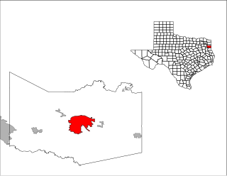
Waskom is a city in Harrison County, Texas, United States. It lies about 20 miles (32 km) east of the county seat, Marshall, on U.S. Route 80. To the east is Shreveport, Louisiana. The population was 2,160 at the 2010 census.

The Atchafalaya River is a 137-mile-long (220 km) distributary of the Mississippi River and Red River in south central Louisiana in the United States. It flows south, just west of the Mississippi River, and is the fifth largest river in North America, by discharge. The name "Atchafalaya" comes from Choctaw for "long river", from hachcha, "river", and falaya, "long".

The Calcasieu River is a river on the Gulf Coast in southwestern Louisiana. Approximately 200 miles (320 km) long, it drains a largely rural area of forests and bayou country, meandering southward to the Gulf of Mexico. The name "Calcasieu" comes from the Indian Atakapa language katkosh, for "eagle", and yok, "to cry".

Bayou Lafourche, originally called Chetimachas River or La Fourche des Chetimaches,, is a 106-mile-long (171 km) bayou in southeastern Louisiana, United States, that flows into the Gulf of Mexico. The bayou is flanked by Louisiana Highway 1 on the west and Louisiana Highway 308 on the east, and is known as "the longest Main Street in the world." It flows through parts of Ascension, Assumption, and Lafourche parishes. Today, approximately 300,000 Louisiana residents drink water drawn from the bayou.

The Atchafalaya Basin, or Atchafalaya Swamp, is the largest wetland and swamp in the United States. Located in south central Louisiana, it is a combination of wetlands and river delta area where the Atchafalaya River and the Gulf of Mexico converge. The river stretches from near Simmesport in the north through parts of eight parishes to the Morgan City southern area.

The Vermilion River is a 70.0-mile-long (112.7 km) bayou in southern Louisiana in the United States. It is formed on the common boundary of Lafayette and St. Martin parishes by a confluence of small bayous flowing from St. Landry Parish, and flows generally southward through Lafayette and Vermilion parishes, past the cities of Lafayette and Abbeville. At the port of Intracoastal City, the Gulf Intracoastal Waterway crosses the river before the latter flows into Vermilion Bay, an inlet of the Gulf of Mexico. The river originates at Bayou Fusilier, which is fed by Bayou Teche; winds its way through Lafayette Parish; and drains into the Vermilion Bay below Vermilion Parish.

Louisiana Highway 1 (LA 1) is a state highway in Louisiana. At 431.88 miles (695.04 km), it is the longest numbered highway of any class in Louisiana. It runs diagonally across the state, connecting the oil and gas fields near the island of Grand Isle with the northwest corner of the state, north of Shreveport.
The Little River is a 96-mile-long (154 km) tributary of the Ouachita (Black) River in central Louisiana in the United States. Via the Ouachita and Red rivers, it is part of the watershed of the Mississippi River. According to the Geographic Names Information System, the Little River has also been known historically as "Bayou Des Nacitoches," "Catahoula Bayou," and "Catahoula River."
Castor Creek or Bayou Castor is a 103-mile-long (166 km) tributary of the Little River in north-central Louisiana in the United States. Via the Little, Ouachita and Red rivers, it is part of the watershed of the Mississippi River.
Island Bayou is a 46.0-mile-long (74.0 km) tributary of the Red River in Oklahoma.

Bayou Plaquemine Brulé is a waterway in the Mermentau River basin of south Louisiana. The bayou is 58 miles (93 km) long and is navigable for 19 miles (31 km) of its lower course.
Big Cypress Creek is an 86-mile-long (138 km) river in Texas. It is part of the Red River watershed, with its water eventually flowing to the Atchafalaya River through the Atchafalaya Basin and entering the Gulf of Mexico.
Big Sandy Creek is a 58.0-mile-long (93.3 km) tributary of the Sabine River in Franklin, Wood and Upshur counties in northeastern Texas.
Black Bayou is a 66.6-mile-long (107.2 km) river in Texas and Louisiana. It is a tributary of Twelvemile Bayou, which feeds Cross Bayou and consequently the Red River and the Mississippi River. It rises in Cass County, Texas, 7 miles (11 km) north of Atlanta, and flows south past Atlanta, then southeast into Caddo Parish, Louisiana. It continues southeast until reaching the Red River floodplain, then curves south and southwest to its confluence with the outlet of Caddo Lake, where Twelvemile Bayou is formed.
Black Cypress Bayou is a 23.3-mile-long (37.5 km) river in Texas. It is a tributary of Big Cypress Bayou and is part of the Red River watershed.
Pecan Bayou is a 52.5-mile-long (84.5 km) tributary of the Red River in Texas. It is located entirely in Red River County, flowing west to east in a course north of Clarksville.

The Little Satilla River is a 28.4-mile-long (45.7 km) freshwater tributary of the Satilla River in the U.S. state of Georgia. It should not be confused with the tidal Little Satilla River that is 20 miles (32 km) to the southeast and is an inlet of the Atlantic Ocean.

Dorcheat Bayou, also known as Bayou Dorcheat, formerly Bayou Dauchite, is a 115-mile-long (185 km) stream in the US that extends from Nevada County in southwestern Arkansas through Columbia County and into Webster Parish in northwestern Louisiana before emptying into Lake Bistineau east of the village of Doyline. To its south, Lake Bistineau joins Loggy Bayou to form a continuous passage of water into the Red River. Sometimes called the "heart of Webster Parish", Dorcheat is known for its "unending bounty of sights and sound" of nature.
Loggy Bayou is a 17.3-mile-long (27.8 km) stream in northwestern Louisiana which connects Lake Bistineau with the Red River. Bistineau is the reservoir of Dorcheat Bayou, which flows 115 miles (185 km) southward from Nevada County, Arkansas, into Webster Parish. Loggy Bayou flows through south Bossier Parish, west of Ringgold, in a southerly direction through Bienville Parish, and into Red River Parish, where north of Coushatta it joins the Red River, a tributary of the Mississippi.