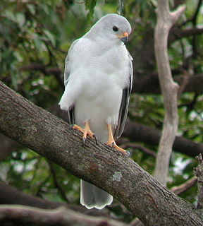
Macrotis, known as bilbies or rabbit-bandicoots, is a genus of desert-dwelling marsupial omnivores; they are members of the order Peramelemorphia. At the time of European colonisation of Australia, there were two species. The lesser bilby became extinct in the 1950s; the greater bilby survives but remains endangered. It is currently listed as a vulnerable species. It is on average 55 cm (22 in) long, excluding the tail, which is usually around 29 cm (11 in) long. Its fur is usually grey or white, it has a long pointy nose and very long ears, hence earning its nick-name, the rabbit-eared bandicoot.

The Texas Blackland Prairies are a temperate grassland ecoregion located in Texas that runs roughly 300 miles (480 km) from the Red River in North Texas to San Antonio in the south. The prairie was named after its rich, dark soil.

Bhadra Wildlife Sanctuary is a protected area and a tiger reserve as part of Project Tiger, located 23 km (14 mi) south of Bhadravathi town and 38 km (24 mi) northwest of Chikkamagaluru town in Karnataka state, India Bhadra sanctuary has a wide range of flora and fauna and is a popular place for day outings. The 1,875 m (6,152 ft) above MSL Hebbe Giri is the highest peak in the sanctuary.

Newhaven Sanctuary, once known as Newhaven station, lies 363 kilometres (226 mi) north-west of Alice Springs at the junction of three distinct bioregions: the Great Sandy Desert, MacDonnell Ranges and Burt Plain in the Northern Territory of Australia.

The Ohlanga River is a river in KwaZulu-Natal, South Africa, which empties into the Indian Ocean just north of Umhlanga, KwaZulu-Natal, north of Durban. The river has extensive reed beds in the estuary at its mouth, which is only 7 km further southwest from the mouth of the Mdloti River. Presently this river is part of the Mvoti to Umzimkulu Water Management Area.
Wongalara Sanctuary is a nature reserve in the Top End of the Northern Territory of Australia.

Mornington Sanctuary, formerly Mornington Station, is a 3,582 km2 (1,383 sq mi) nature reserve in the Kimberley region of north-west Western Australia. It contains the Mornington Wilderness Camp and is owned and managed by the Australian Wildlife Conservancy (AWC). It lies in the Pentecost subregion of the Central Kimberley Bioregion.

The Game & Wildlife Conservation Trust is a British charitable organisation promoting game and wildlife management as an essential part of nature conservation, whilst working very closely with the shooting and hunting community. For over 75 years the Trust has been conducting scientific research to understand why there have been declines in species such as the grey partridge, black grouse, water vole, corn bunting and brown hare.
The Australian Wildlife Conservancy (AWC) is an Australian independent, non-profit organisation, working to conserve threatened wildlife and ecosystems in Australia. This is principally achieved through the acquisition of extensive areas of land on which to establish conservation reserves or by entering into partnerships with government and Indigenous groups to manage landscapes for effective conservation. AWC currently manage 28 sanctuaries for wildlife conservation that cover over 4.8 million hectares of land across Australia.
Brooklyn Sanctuary is a 600 km2 (232 sq mi) nature reserve in north-east Queensland, Australia, less than 100 km (62 mi) north-west of Cairns. It is owned and managed by the Australian Wildlife Conservancy by which it was acquired in 2004. It is located on the boundary of the Wet Tropics bioregion and Einasleigh Uplands bioregion on the Mount Carbine Tableland. The landscape varies widely from rugged, rainforested peaks of up to 1,200 m altitude, with an annual rainfall of 4,000 mm, to drier lowland plains in the upper reaches of the Mitchell River with less than 900 mm. It is important for the conservation of upland endemic species. Part of the property is inscribed on the World Heritage List.
Mount Zero-Taravale Sanctuary is a 600 km² nature reserve in north-east Queensland, Australia, 60 km north-west of Townsville. It is owned and managed by the Australian Wildlife Conservancy (AWC). It is located on the boundary of the Wet Tropics bioregion and Einasleigh Uplands bioregion, adjacent to the Wet Tropics World Heritage Area. The property varies in altitude from 350 m in the south-west to 1,050 m in the north-east, and in landform from rugged mountains to a broad alluvial valley. The vegetation includes rainforest, grassy eucalypt woodlands and open Hoop Pine woodlands. Annual rainfall varies from 900 mm in the southern section to 1300 mm in the north-east.
Karakamia Sanctuary is a 2.75 km² nature reserve in south-west Western Australia, 4 km from Chidlow and 50 km north-east of Perth. It is located within the Jarrah forest of the Darling Scarp and is owned and managed by the Australian Wildlife Conservancy (AWC).

Mount Gibson Sanctuary is a 1,305-square-kilometre (504 sq mi) nature reserve on the northern edge of the Wheatbelt and the southern margin of uncleared rangeland country, 350 kilometres (220 mi) north-east of Perth in mid-west Western Australia. The nearest large town is Dalwallinu. It is in the Avon-Wheatbelt Bioregion and is owned and managed by the Australian Wildlife Conservancy (AWC).

Kalamurina Sanctuary is a nature reserve in arid north-eastern South Australia.

Scotia Sanctuary is a 650 km2 (250 sq mi) nature reserve in the south-western plains of New South Wales, Australia, adjacent to the border with South Australia. It is located in the Murray Mallee subregion of the Murray-Darling Depression Bioregion, 150 km (93 mi) south of the city of Broken Hill. It is owned and managed by the Australian Wildlife Conservancy (AWC).
Yookamurra Sanctuary is a 50 km2 nature reserve in the Murraylands region of South Australia, between the eastern slopes of the Mount Lofty Ranges and the Murray River, 24 km north-east of the town of Sedan. It is owned and managed by the Australian Wildlife Conservancy (AWC).

For the cattle station in the channel country of Queensland, see Marion Downs Station

Piccaninny Plains Wildlife Sanctuary is a 1700 km² nature reserve on the Cape York Peninsula of Far North Queensland, Australia. A former cattle station adjacent to Mungkan Kandju National Park, it is managed by the Australian Wildlife Conservancy (AWC). It is jointly owned by The Tony and Lisette Lewis Foundation and the Australian Wildlife Conservancy, by which it was purchased in 2008.

Bowra Sanctuary is a 140 km2 nature reserve near Cunnamulla in South West Queensland, Australia. It lies in the Mulga Lands bioregion on the Warrego River plains, in the catchment of the Warrego and Paroo Rivers. It is owned and managed by the Australian Wildlife Conservancy (AWC).