
Wongalara
Location in Northern Territory
Wongalara Sanctuary is a nature reserve in the Top End of the Northern Territory of Australia.
Wongalara Sanctuary is a nature reserve in the Top End of the Northern Territory of Australia.
It is a pastoral lease on the southern border of Arnhem Land, and is 120 kilometres (75 mi) south-east of Kakadu National Park. The sanctuary shares a boundary with Mainoru Station and vacant crown land to the north, Mountain Valley Station to the west, Lonesome Dove and Big River Stations to the south and Urapunga Aboriginal land trust to the south and South-East Arnhem Land Indigenous Protected Area to the east and southeast. [1]
The sanctuary occupies an area of 1,910 square kilometres (737 sq mi), [2] it is owned and managed by the Australian Wildlife Conservancy (AWC), which acquired it in 2007 following a public fundraising campaign and assistance from the Australian Government in the form of a grant of A$2.1 million from its National Reserve System Program. [3] The Mainoru River, Jalbot River and Wilton River all flow through the area. The nearest major road to the sanctuary is the Central Arnhem Road which cuts through neighbouring properties to the north and east. [1]
The landscape of Wongalara includes spinifex-covered ranges, sandstone plateaus and escarpments, eucalypt forests and woodlands, patches of monsoon rainforest and wetlands. The Wilton River flows through the reserve. [3] The dominant vegetation is low open savannah woodland. [2]
Threatened or significant animal species recorded from Wongalara include the northern masked owl, [4] Gouldian finch, crested shrike-tit, hooded parrot, red goshawk, northern quoll, kakadu dunnart and freshwater crocodile. [3] Scientists come to the sanctuary during the dry season to trap and study mammals and conduct other research projects. [5] By 2013 a 1,000 square kilometres (386 sq mi) section of the property has been fenced to protect wildlife from feral pests. Feral cattle, buffalo, horses and pigs have all been excluded from the property. These animals all compete with natives for food and destroy the landscape and thin the vegetation. The cost of the 160 kilometres (99 mi) fence is A$500,000 with plans to fence the entire property creating the largest feral herbivore-free area in Australia. [6] [7]
The protected areas of the Northern Territory consists of protected areas managed by the governments of the Northern Territory and Australia and private organisations with a reported total area of 335,527 square kilometres (129,548 sq mi) being 24.8% of the total area of the Northern Territory of Australia.

Kakadu National Park is a protected area in the Northern Territory of Australia, 171 km (106 mi) southeast of Darwin. It is a World Heritage Site. Kakadu is also gazetted as a locality, covering the same area as the national park, with 313 people recorded living there in the 2016 Australian census.

The Top End of Australia's Northern Territory is a geographical region encompassing the northernmost section of the Northern Territory, which aside from the Cape York Peninsula is the northernmost part of the Australian continent. It covers a rather vaguely defined area of about 245,000 km² behind the northern coast from the Northern Territory capital of Darwin across to Arnhem Land with the Indian Ocean on the west, the Arafura Sea to the north, and the Gulf of Carpentaria to the east, and with the almost waterless semi-arid interior of Australia to the south, beyond the huge Kakadu National Park.

Arnhem Land is a historical region of the Northern Territory of Australia, with the term still in use. It is located in the north-eastern corner of the territory and is around 500 km (310 mi) from the territory capital, Darwin. In 1623, Dutch East India Company captain Willem Joosten van Colster sailed into the Gulf of Carpentaria and Cape Arnhem is named after his ship, the Arnhem, which itself was named after the city of Arnhem in the Netherlands.
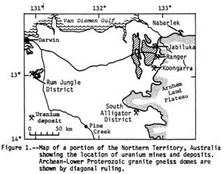
Alligator Rivers is the name of an area in an Arnhem Land region of the Northern Territory of Australia, containing three rivers, the East, West, and South Alligator Rivers. It is regarded as one of the richest biological regions in Australia, with part of the region in the Kakadu National Park. It is an Important Bird Area (IBA), lying to the east of the Adelaide and Mary River Floodplains IBA. It also contains mineral deposits, especially uranium, and the Ranger Uranium Mine is located there. The area is also rich in Australian Aboriginal art, with 1500 sites. The Kakadu National Park is one of the few World Heritage sites on the list because of both its natural and human heritage values. They were explored by Lieutenant Phillip Parker King in 1820, who named them in the mistaken belief that the crocodiles in the estuaries were alligators.

Gunbalanya is an Aboriginal Australian town in west Arnhem Land in the Northern Territory of Australia, about 300 kilometres (190 mi) east of Darwin. The main language spoken in the community is Kunwinjku. At the 2021 Australian census, Gunbalanya had a population of 1,177.

The western quoll is Western Australia's largest endemic mammalian carnivore. One of the many marsupial mammals native to Australia, it is also known as the chuditch. The species is currently classed as near-threatened.
Newhaven Wildlife Sanctuary, once a cattle station known as Newhaven Station is an Australian nature reserve. It lies around 300–400 kilometres (186–249 mi) north-west of Alice Springs in the Northern Territory of Australia. It is jointly operated by Birds Australia and the Australian Wildlife Conservancy.
The Australian Wildlife Conservancy (AWC) is an Australian independent, nonprofit organisation, working to conserve threatened wildlife and ecosystems in Australia. This is principally achieved through the acquisition of extensive areas of land on which to establish conservation reserves ("sanctuaries") or by entering into partnerships with government, Indigenous groups, and private landholders to manage landscapes for effective conservation. AWC is the largest private owner and manager of land for conservation in Australia, currently managing 31 sanctuaries and partnership sites for wildlife conservation that cover over 6.5 million hectares of land across Australia.
Karakamia Sanctuary is a 2.75 km2 nature reserve in south-west Western Australia, 4 km from Chidlow and 50 km north-east of Perth. It is located within the jarrah forest of the Darling Scarp and is owned and managed by the Australian Wildlife Conservancy (AWC).

Mount Gibson Sanctuary is a 1,305-square-kilometre (504 sq mi) nature reserve on the northern edge of the Wheatbelt and the southern margin of uncleared rangeland country, 350 kilometres (220 mi) north-east of Perth in mid-west Western Australia. The nearest large town is Dalwallinu. It is in the Avon-Wheatbelt Bioregion and is owned and managed by the Australian Wildlife Conservancy (AWC).
Kalamurina Sanctuary is a nature reserve in arid north-eastern South Australia. The land was established as a sheep station sometime before 1994 and then a cattle station until the early 2000s, called Kalamurina Station. It occupies 6,700 square kilometres (2,587 sq mi).

Marion Downs Sanctuary, a former cattle station, is a 2,890 square kilometres (1,116 sq mi) nature reserve in the Kimberley region of north-west Western Australia.
Pungalina-Seven Emu Sanctuary is a 3060 km2 private protected area in the Northern Territory of Australia. It is managed by the Australian Wildlife Conservancy (AWC) which purchased Pungalina Station in 2009, with some assistance from the Wildlife Australia Fund. It adjoins the Gulf of Carpentaria near the border with Queensland, lying in the Gulf Coastal bioregion. The reserve is bordered by Calvert Hills and Wollogorang Stations to the south and east. The nearest town is Borroloola, 150 km to the west.
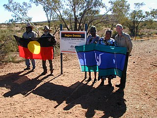
Angas Downs Indigenous Protected Area (IPA) is an Aboriginal Australian-owned 320,500-hectare (1,237 sq mi) pastoral lease, within the MacDonnell Shire area, 300 kilometres (190 mi) south-west of Alice Springs, Northern Territory, 135 kilometres (84 mi) east from Uluṟu-Kata Tjuṯa National Park, 100 kilometres (62 mi) south-east of Kings Canyon/Watarrka National Park and 40 kilometres (25 mi) from Mount Ebenezer Roadhouse on the Lasseter Highway. The property is a pastoral lease held by the Imanpa Development Association.
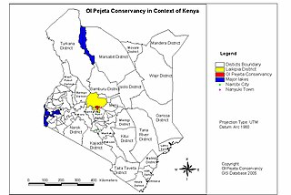
The Ol Pejeta Conservancy is a 360 km2 (140 sq mi) not-for-profit wildlife conservancy in Central Kenya's Laikipia County. It is situated on the equator west of Nanyuki, between the foothills of the Aberdares and Mount Kenya. The Ol Pejeta Conservancy works to conserve wildlife, provide a sanctuary for great apes, and generate income through wildlife tourism and complementary enterprises for re-investment in conservation and community development.
Charnley River–Artesian Range Wildlife Sanctuary is a protected area covering about 3,000 square kilometres (1,200 sq mi) in the Kimberley region of Western Australia. It is situated about 205 kilometres (127 mi) east of Derby and 287 kilometres (178 mi) north west of Halls Creek, and is accessed via the Gibb River Road. It is named after the Charnley River that flows through the property.
Tanumbirini Station is a pastoral lease on formerly what were Kotandji lands that operates as a cattle station in Northern Territory of Australia.
Wollogorang Station is a pastoral lease that operates as a cattle station straddling the border the Northern Territory and Queensland.
Amungee Mungee Station is a pastoral lease that operates as a cattle station in the Northern Territory of Australia.