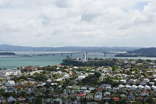
Devonport is a harbourside suburb of Auckland, New Zealand. It is located on the North Shore, at the southern end of the Devonport Peninsula that runs southeast from near Lake Pupuke in Takapuna, forming the northern side of the Waitematā Harbour. East of Devonport lies North Head, the northern promontory guarding the mouth of the harbour.

Mount Victoria is a suburb of central Wellington, New Zealand, named after the 196 metres (643 ft) hill Mount Victoria to the east. Mount Victoria's residential area is on its north-western slopes.

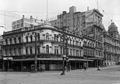
Queen Street is the major commercial thoroughfare in the Auckland CBD, Auckland, New Zealand's main population centre. The northern end is at Queens Wharf on the Auckland waterfront, adjacent to the Britomart Transport Centre and the Downtown Ferry Terminal. The road is close to straight, the southern end being almost three kilometres away in a south-southwesterly direction on the Karangahape Road ridge, close to the residential suburbs in the interior of the Auckland isthmus.

Waitematā Harbour is the main access by sea to Auckland, New Zealand. For this reason it is often referred to as Auckland Harbour, despite the fact that it is one of two harbours adjoining the city. The harbour forms the northern and eastern coasts of the Auckland isthmus and is crossed by the Auckland Harbour Bridge. It is matched on the southern side of the city by the shallower waters of the Manukau Harbour.

Onehunga is a suburb of Auckland in New Zealand and the location of the Port of Onehunga, the city's small port on the Manukau Harbour. It is eight kilometres south of the city centre, close to the volcanic cone of Maungakiekie / One Tree Hill.

Remuera is an affluent suburb in Auckland, New Zealand. It is located four kilometres southeast of the city centre. Remuera is characterised by many large houses, often Edwardian or mid 20th century. A prime example of a "leafy" suburb, Remuera is noted for its quiet tree lined streets. The suburb has numerous green spaces, most obvious of which is Ōhinerau / Mount Hobson – a volcanic cone with views from the top overlooking Waitematā Harbour and Rangitoto.

Viaduct Harbour, formerly known as Viaduct Basin, is a former commercial harbour on the Auckland waterfront that has been turned into a development of mostly upscale apartments, office space and restaurants. It is located on the site of a formerly run-down area of the Freemans Bay / Auckland CBD waterfront in Auckland, New Zealand. As a centre of activity of the 2000 America's Cup hosted by the Royal New Zealand Yacht Squadron, as well as the 2022 Rally New Zealand, the precinct enjoyed considerable popularity with locals and foreign visitors.

Waitematā railway station, commonly known as Britomart railway station or Britomart Transport Centre, is the public transport hub in the central business district of Auckland and the northern terminus of the North Island Main Trunk railway line. It combines a railway station in a former Edwardian post office, extended with expansive modernist architectural elements, with a bus interchange. It is at the foot of Queen Street, the main commercial thoroughfare of the CBD, with the main ferry terminal just across Quay Street.

Mechanics Bay is a reclaimed bay on the Waitematā Harbour in Auckland, New Zealand. It is also the name of the area of the former bay that is now mainly occupied by commercial and port facilities. Sometimes the bay formed between Tāmaki Drive and the western reclamation edge of Fergusson Container Terminal is also referred to as Mechanics Bay.
Stanley Point is a small suburb located on the North Shore of Auckland, New Zealand. It is located near Devonport, another suburb. It is mostly residential. The Devonport Naval Base lies to the east of the bay on the south side of the Stanley Bay peninsula and is connected to storage facilities on the north side at Ngataringa Bay by a tunnel.

Opua is a locality in the Bay of Islands, in the sub-tropical Northland Region of New Zealand. It is notable as the first port for overseas yachts arriving in the country after crossing the Pacific Ocean. In the original 1870s plans for the town, it was named Newport. The town of Paihia is nearby, and the small settlement of Te Haumi is in between.

Commercial Bay was a historic bay on the southern side of the Waitematā Harbour that defined the original extent of the Auckland waterfront in Auckland, New Zealand. Today, the name Commercial Bay refers the heavily developed area around lower Queen Street and Viaduct Harbour.

The Wynyard Quarter is a reclaimed piece of land on the Waitematā Harbour at the western edge of the Auckland waterfront, New Zealand.

The Auckland Central Business District (CBD), or Auckland city centre, is the geographical and economic heart of the Auckland metropolitan area. It is the area in which Auckland was established in 1840, by William Hobson on land gifted by mana whenuahapū Ngāti Whātua Ōrākei. It is New Zealand's leading financial hub, and the centre of the country's economy; the GDP of the Auckland Region was NZD$139 billion in the year ending September 2023.
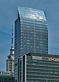
Commercial Bay Shopping Centre is a shopping centre in the Auckland CBD, Auckland, New Zealand. It is situated at 11–19 Customs Street West between Lower Albert Street and the Britomart Transport Centre, and opened in 2020.
Point Britomart was a headland in the Waitematā Harbour, in Auckland, New Zealand. Located between Commercial Bay and Official Bay, the point was later quarried away to produce fill for land reclamation in Mechanics Bay, and almost no physical trace remains at street level in what is today an area of the Auckland CBD and the Auckland waterfront.

Hobson Street is the major street in Auckland, New Zealand. It lies on the western side of Queen Street. It is a commercial and high-rise residential street, and provides access to the Auckland Northern Motorway going south, and the Northwest Motorway going west. For most of its length it is one-way. One block to the west is Nelson Street, which is one-way in the other direction and provides access to the central city for traffic exiting from the motorways. One block to the east is Albert Street, part of Mayoral Drive, and Vincent Street. The area encompassed by these streets is called Hobson Ridge by Statistics New Zealand.

Quay Street is the northernmost street in the Auckland CBD, New Zealand. The Auckland Ferry Terminal, which has ferries running to Devonport, Waiheke Island, and other places in Waitematā Harbour; the Hilton Auckland hotel; and Ports of Auckland are on the north side of the street. The Britomart Transport Centre, Queen Elizabeth Square and Grand Mercure Auckland hotel are on the south side.

Shortland Street was the initial commercial street of Auckland and remains a key financial and legal centre for Auckland city. It runs east from Queen Street up to Princes Street, providing a connection from the business district to the Auckland High Court and University of Auckland.

Anzac Avenue is a street in Auckland, New Zealand's most populous city. It was constructed between 1914 and 1919 to link Beach Road to Symonds Street, and was named as a memorial to the troops who died in the Gallipoli campaign.