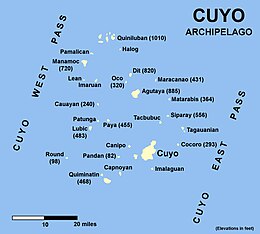
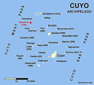
The Cuyo Archipelago or Cuyo Islands, is a group of about 45 islands lying to the northeast of the Philippines island of Palawan.[1] It lies south of Mindoro and between Northern Palawan and Panay. It is centered on the largest island of the archipelago, Cuyo Island, with an area of 22 square miles (57km2) and is about 9 miles (14km) long.
The 45 islands and islets of the archipelago form a total land area of 50 square miles (130km2).[2] Cuyo is divided into two island groups. To the north is the Quiniluban group. To the south is the Cuyo group, where the centers of the three municipalities namely Cuyo, Agutaya, and Magsaysay are located.
Geologically, the islands are related to the main island of Palawan. They are positioned on the western edge of the Luzon Arc.[2] Cuyo island is volcanic. The northern islands of Quiniluban seem to be uplifted coral atolls, although the heights of some of the peaks strongly suggest volcanic uplift. There have been plans before to establish the Cuyo Archipelago as a separate province from Palawan, just like what happened when Batanes became independent from Cagayan province.[2] Many other islands of the group are purely corallian.[2]
Cuyo is divided in three municipalities, namely Cuyo, Agutaya, and Magsaysay:
Palawan, officially the Province of Palawan, is an archipelagic province of the Philippines that is located in the region of Mimaropa. It is the largest province in the country in terms of total area of jurisdiction. Its capital is the city of Puerto Princesa, but the city is governed independently from the province as a highly urbanized city.
The Sulu Sea is a body of water in the southwestern area of the Philippines, separated from the South China Sea in the northwest by Palawan and from the Celebes Sea in the southeast by the Sulu Archipelago. Borneo is found to the southwest and Visayas to the northeast.
Busuanga, officially the Municipality of Busuanga, is a 3rd class municipality in the province of Palawan, Philippines. According to the 2015 census, it has a population of 22,046 people.
Coron, officially the Municipality of Coron, is a 1st class municipality in the province of Palawan, Philippines. According to the 2015 census, it has a population of 51,803 people.
Lubang Island is the largest island in the Lubang Group of Islands, an archipelago which lies to the northwest of the northern end of Mindoro in the Philippines. The Lubang Islands are about 150 kilometres (93 mi) southwest of Manila. There are seven islands in the group. The island is divided into two municipalities. The largest settlement is the town of Lubang, the northwest end of the island. Its town center is about 8 miles (13 km) northwest of Tilik Port, the only safe anchorage on Lubang Island. The southeastern half of the island is covered by the Municipality of Looc. The Lubang island group, which constitutes all the seven islands, are geographically distinct from any landmass, making it biologically unique - and endangered at the same time. The islands are under consideration to be set aside as a UNESCO tentative site.
Ratagnon is a regional language spoken by the Ratagnon people, an indigenous group from Occidental Mindoro. It is a part of the Bisayan language family and is closely related to other Philippine languages. Its speakers are shifting to Tagalog, and it is nearly extinct.
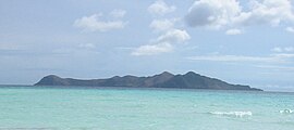
Manamoc is an island-barangay in the Sulu Sea, in the northeastern part of the province of Palawan in the Philippines. It is a part of the Quiniluban group of islands of the Cuyo Archipelago between the islands of Palawan and Panay.
Culion, officially the Municipality of Culion, is a 3rd class municipality in the province of Palawan, Philippines. According to the 2015 census, it has a population of 20,139 people.
Agutaya, officially the Municipality of Agutaya, is a 5th class municipality in the province of Palawan, Philippines. According to the 2015 census, it has a population of 12,545 people.
Cagayancillo, officially the Municipality of Cagayancillo, is a 6th class municipality in the province of Palawan, Philippines. According to the 2015 census, it has a population of 6,285 people.
Cuyo, officially the Municipality of Cuyo, is a 4th class municipality in the province of Palawan, Philippines. According to the 2015 census, it has a population of 22,360 people.
Magsaysay, officially the Municipality of Magsaysay, is a 5th class municipality in the province of Palawan, Philippines. According to the 2015 census, it has a population of 12,196 people.
San Vicente, officially the Municipality of San Vicente, is a 1st class municipality in the province of Palawan, Philippines. According to the 2015 census, it has a population of 31,232 people.
The Agutaynen language is spoken on Agutaya Island in the province of Palawan in the Philippines.
The legislative districts of Palawan are the representations of the province of Palawan and the highly urbanized city of Puerto Princesa in the various national legislatures of the Philippines. The province and the city are currently represented in the lower house of the Congress of the Philippines through their first, second, and third congressional districts.
Cuyo Airport is an airport serving the municipalities of Magsaysay, Cuyo, and Agutaya. It is located within the boundaries of Barangay Lucbuan and Emilod in the town of Magsaysay in the main island of Cuyo Island. It is one of several airports in Palawan, the other being Puerto Princesa Airport, Cesar Lim Rodriguez Airport, El Nido Airport and Francisco Reyes Airport in the municipality of Busuanga. It is classified as a feeder airport by the Civil Aviation Authority of the Philippines, a body of the Department of Transportation that is responsible for the operations of not only this airport but also of all other airports in the Philippines except the major international airports.
The Philippine Mobile Belt is a complex portion of the tectonic boundary between the Eurasian Plate and the Philippine Sea Plate, comprising most of the country of the Philippines. It includes two subduction zones, the Manila Trench to the west and the Philippine Trench to the east, as well as the Philippine Fault System. Within the Belt, a number of crustal blocks or microplates which have been shorn off the adjoining major plates are undergoing massive deformation.
The Quiniluban Group is a group of islands in Palawan Province of the Philippines situated between the islands of Palawan and Panay in the Sulu Sea. The group is the northernmost in the Cuyo Archipelago, consisting of several islands and rocks. The easternmost of which is a circular group of islands surrounded by reef about 6 nautical miles in diameter. The largest of the circular group is Quiniluban Island. The island group also includes the upscale resort island of Pamican located about 5.6 nautical miles southwest of the circular group, and Manamoc Island located 3.0 nautical miles further southwest of Pamilacan.
A plebiscite will be held on March 13, 2021 regarding the approval of Republic Act No. 11259 which proposed dividing of Palawan in the Philippines into three separate provinces; Palawan del Norte, Palawan del Sur, and Palawan Oriental. The plebiscite was originally scheduled to take place on May 11, 2020 but was postponed due to quarantine measures implemented in response to the COVID-19 pandemic in the Philippines.
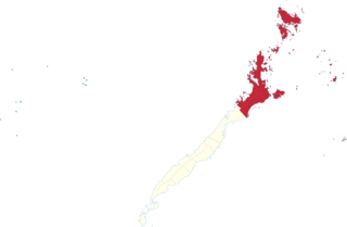
Palawan's 1st congressional district is one of the three congressional districts of the Philippines in the province of Palawan. It has been represented in the House of Representatives since 1987. The district encompasses the northern portion of Palawan Island including the Calamianes, Cuyo and Kalayaan island chains. It consists of the municipalities of Agutaya, Araceli, Busuanga, Cagayancillo, Coron, Culion, Cuyo, Dumaran, El Nido, Kalayaan, Linapacan, Magsaysay, Roxas, San Vicente and Taytay. The district is currently represented in the 18th Congress by Franz Josef Alvarez of the National Unity Party (NUP).
This page is based on this Wikipedia article Text is available under the CC BY-SA 4.0 license; additional terms may apply. Images, videos and audio are available under their respective licenses.