
Below is a timeline of the 2007 North Indian Ocean cyclone season, documenting major events with regards to tropical cyclone formation, strengthening, weakening, landfall, extratropical transition, as well as dissipation. The 2007 North Indian Ocean cyclone season was an ongoing event in the annual cycle of tropical cyclone formation.

The 2002 North Indian Ocean cyclone season was a below average season in terms of tropical cyclone formation. The season had no official bounds, but most storms formed in either May or after October. No depressions or storms formed during the monsoon season from July to September, the first such instance on record. There are two main seas in the North Indian Ocean – the Bay of Bengal to the east of the Indian subcontinent – and the Arabian Sea to the west of India. The official Regional Specialized Meteorological Centre in this basin is the India Meteorological Department (IMD), while the Joint Typhoon Warning Center (JTWC) releases unofficial advisories. An average of four to six storms form in the North Indian Ocean every season with peaks in May and November. Cyclones occurring between the meridians 45°E and 100°E are included in the season by the IMD.

The 2000 North Indian Ocean cyclone season was fairly quiet compared to its predecessor, with all of the activity originating in the Bay of Bengal. The basin comprises the Indian Ocean north of the equator, with warnings issued by the India Meteorological Department (IMD) in New Delhi. There were six depressions throughout the year, of which five intensified into cyclonic storms – tropical cyclones with winds of 65 mph (105 km/h) sustained over 3 minutes. Two of the storms strengthened into a Very Severe Cyclonic Storm, which has winds of at least 120 km/h (75 mph), equivalent to a minimal hurricane. The Joint Typhoon Warning Center (JTWC) also tracked storms in the basin on an unofficial basis, estimating winds sustained over 1 minute.

The 1994 North Indian Ocean cyclone season was a below-average year in which eight tropical cyclones affected seven countries bordering the North Indian Ocean. The India Meteorological Department tracks all tropical cyclones in the basin, north of the equator. The first system developed on March 21 in the Bay of Bengal, the first March storm in the basin since 1938. The second storm was the most powerful cyclone of the season, attaining maximum sustained winds of 215 km/h (135 mph) in the northern Bay of Bengal. Making landfall near the border of Bangladesh and Myanmar, the cyclone killed 350 people and left US$125 million in damage.

The 2009 North Indian Ocean cyclone season was an event in the annual cycle of tropical cyclone formation. The North Indian Ocean cyclone season has no official bounds, but cyclones tend to form between April and December, with peaks in May and November. These dates conventionally delimit the period of each year when most tropical cyclones form in the northern Indian Ocean.

The 2010 North Indian Ocean cyclone season was the one of the most active tropical cyclone season in the North Indian Ocean since 1998. The season saw 8 depressions and 5 named storms forming in the region.
This is a timeline of the 2009 North Indian Ocean cyclone season, which contains details of when a depression forms, strengthens, weakens, makes landfalls, and dissipates during the 2009 North Indian Ocean cyclone season. It also includes information from post-storm analysis by the Joint Typhoon Warning Center (JTWC), and the India Meteorological Department (IMD) who run the Regional Specialized Meteorological Center in New Delhi, India. RSMC New Delhi's area of responsibility is officially between 45°E and 100E which is east of the Horn of Africa and west of the Malay Peninsula. There are two main seas within the North Indian Ocean, the Arabian Sea and the Bay of Bengal. For storms, these are abbreviated as BOB and ARB by the IMD.

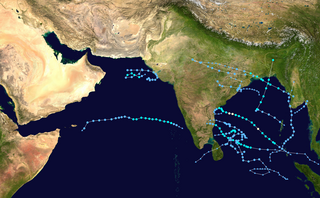
The 2011 North Indian Ocean cyclone season was the least active tropical cyclone season in the North Indian Ocean since 1993. Only two cyclonic storms formed, below the average of four to six. The North Indian Ocean cyclone season has no official bounds, but cyclones tend to form between April and December, with peaks in May and November. These dates conventionally delimit the period of each year when most tropical cyclones form in the northern Indian Ocean. The scope of this article is limited to the Indian Ocean in the Northern Hemisphere, east of the Horn of Africa and west of the Malay Peninsula. There are two main seas in the North Indian Ocean — the Arabian Sea to the west of the Indian subcontinent, abbreviated ARB by the India Meteorological Department (IMD); and the Bay of Bengal to the east, abbreviated BOB by the IMD.

The 2013 North Indian Ocean cyclone season was an event in the annual cycle of tropical cyclone formation, in which tropical cyclones formed in the North Indian Ocean and Arabian Sea. The season had no official bounds, but cyclones typically formed between May and December, with the peak from October to November. These dates conventionally delimit the period of each year when most tropical cyclones form in the northern Indian Ocean.

The 2014 North Indian Ocean cyclone season was an event in the annual cycle of tropical cyclone formation. The season included two very severe cyclonic storms, both in October, and one other named cyclonic storm, classified according to the tropical cyclone intensity scale of the India Meteorological Department. Cyclone Hudhud is estimated to have caused US$3.58 billion in damage across eastern India, and more than 120 deaths.

Extremely Severe Cyclonic Storm Phailin was the most intense tropical cyclone to make landfall in India since the 1999 Odisha cyclone until Cyclone Amphan hit West Bengal in May 2020. The system was first noted as a tropical depression on October 4, 2013 within the Gulf of Thailand, to the west of Phnom Penh in Cambodia. Over the next few days, it moved westwards within an area of low to moderate vertical wind shear, before as it passed over the Malay Peninsula, it moved out of the Western Pacific Basin on October 6. It emerged into the Andaman Sea during the next day and moved west-northwest into an improving environment for further development before the system was named Phailin on October 9, after it had developed into a cyclonic storm and passed over the Andaman and Nicobar Islands into the Bay of Bengal.

The 2015 North Indian Ocean cyclone season was an event in the annual cycle of tropical cyclone formation. The North Indian Ocean cyclone season has no official bounds, but cyclones tend to form between months of April and December, with the peak from May to November. These dates conventionally delimit the period of each year when most tropical cyclones form in the northern Indian Ocean.

The 2016 North Indian Ocean cyclone season was an event in the annual cycle of tropical cyclone formation. It was the deadliest season since 2010, killing more than 400 people. The season was an average one, seeing four named storms, with one further intensifying into a very severe cyclonic storm. The first named storm, Roanu, developed on 19 May while the season's last named storm, Vardah, dissipated on 18 December. The North Indian Ocean cyclone season has no official bounds, but cyclones tend to form between April and December, with the two peaks in May and November. These dates conventionally delimit the period of each year when most tropical cyclones form in the northern Indian Ocean.

The 2017 North Indian Ocean cyclone season was a below average yet deadly season in the annual cycle of tropical cyclone formation. This season produced only three named storms, of which one only intensified into a very severe cyclonic storm. The North Indian Ocean cyclone season has no official bounds but cyclones tend to form between April and December with the two peaks in May and November. These dates conventionally delimit the period of each year when most tropical cyclones form in the northern Indian Ocean. The season began with the formation Cyclone Maarutha on April 15 and ended with the dissipation of a deep depression on December 9.

The 2019 North Indian Ocean cyclone season was the most active North Indian Ocean cyclone season on record, in terms of cyclonic storms, however the 1992 season was more active according to the Joint Typhoon Warning Center. The season featured 12 depressions, 11 deep depressions, 8 cyclonic storms, 6 severe cyclonic storms, 6 very severe cyclonic storms, 3 extremely severe cyclonic storms, and 1 super cyclonic storm, Kyarr, the first since Cyclone Gonu in 2007. Additionally, it was also the third-costliest season recorded in the North Indian Ocean, only behind the 2020 and 2008 seasons.

The 2020 North Indian Ocean cyclone season was the costliest North Indian Ocean cyclone season on record, mostly due to Cyclone Amphan. The North Indian Ocean cyclone season has no official bounds, but cyclones tend to form between April and November, with peaks in late April to May and October to November. These dates conventionally delimit the period of each year when most tropical cyclones form in the northern Indian Ocean. The season began on May 16 with the designation of Depression BOB 01 in the Bay of Bengal, which later became Amphan. Cyclone Amphan was the strongest storm in the Bay of Bengal in 21 years and would break Nargis of 2008's record as the costliest storm in the North Indian Ocean. The season concluded with the dissipation of Cyclone Burevi on December 5. Overall, the season was slightly above average, seeing the development of five cyclonic storms.

Cyclonic Storm Maarutha was the first tropical cyclone to make landfall in Myanmar in April. The first tropical cyclone and named storm of the 2017 North Indian Ocean cyclone season, Maarutha was a relatively short-lived and weak system, nonetheless causing notable damage in Myanmar. Maarutha formed from an area of low pressure over the southern Bay of Bengal on April 15. The next morning, RSMC New Delhi upgraded the low-pressure area to a Depression and designated it as BOB 01.
The 2022 North Indian Ocean cyclone season is an ongoing event in the annual cycle of tropical cyclone formation. The North Indian Ocean cyclone season has no official bounds, but cyclones tend to form between April and December, with the peak from May to November. These dates conventionally delimit the period of each year when most tropical cyclones form in the northern Indian Ocean.

2000 South Indian Cyclone was the strongest, most intense tropical cyclone of the fairly-quiet 2000 North Indian Ocean cyclone season. The fifth cyclone, and the fourth named storm, Extremely Severe Cyclonic Storm BOB 05 started as an upper-level low over the Andaman Sea on November 24. On early November 26, the group of thunderstorms was classified as a depression by the IMD. The system slowly began to organize, and late on November 26 the JTWC named it as Tropical Cyclone 03B. By November 28, a 20 km (12 mi)-wide eye was developing, prompting the JTWC to upgrade the storm to the equivalent of a minimal hurricane with winds of 120 km/h (75 mph). By comparison, the IMD estimated peak winds of 190 km/h (120 mph). Wind shear in the region prevented further strengthening, and the storm weakened slightly before making landfall on November 29 in eastern India near Cuddalore. A station there recorded a pressure of 983 mbar (29.0 inHg).

Severe Cyclonic Storm Asani was a strong tropical cyclone that made landfall in India in May 2022. The third depression and deep depression, and the first named storm of the 2022 North Indian Ocean cyclone season, Asani originated from a depression that the Indian Meteorological Department first monitored on May 7. Conditions rapidly favored development as the system became a deep depression by that day before intensifying to a Cyclonic Storm Asani. On the next day it further intensified and peak to a severe cyclonic storm, before making landfall as a deep depression system over Andhra Pradesh. It degenerated into a well marked low-pressure on May 12.


