
Elm Creek is an unincorporated community recognized as a local urban district in Manitoba, Canada. It is about 50 km west of Winnipeg and about 35 km southeast of Portage la Prairie. It is located in the Rural Municipality of Grey. It is home to the second largest fire hydrant in the world which was unveiled on Canada Day, 2001. It is also the home of the second largest H4 chondrite ever found in Canada. The 8.2-kg mass was found by a local grader driver on a rural road in 1997. Elm Creek has a Kindergarten to Grade 12 school.
Plum Coulee is an unincorporated urban community in the Municipality of Rhineland within the Canadian province of Manitoba that held town status prior to January 1, 2015. It is west of Altona, one hour southwest of Winnipeg and 22 kilometres from the United States border. It is also the former home to the Plum Coulee Xpress hockey club. It has an artificial beach located in town called Sunset Beach.
Ashern is a local urban district located in the Municipality of West Interlake in Manitoba's Interlake Region.
Lundar is a local urban district in the Rural Municipality of Coldwell, Manitoba, Canada. Located in Manitoba's Interlake Region, it is situated 99 km (62 mi) north of Winnipeg on Highway 6.

Baldur is an unincorporated community recognized as a local urban district in the Canadian province of Manitoba, located in the Rural Municipality of Argyle. Baldur is the largest community of the municipality, which is in southwestern Manitoba between Brandon and Portage la Prairie. The community is named after the Norse god Baldur.
Binscarth is an unincorporated urban community in the Municipality of Russell – Binscarth, Manitoba. It is located approximately 167 km (104 mi) northwest of Brandon, 16 km (9.9 mi) south from Russell, and 16 km (10 mi) east of the Saskatchewan border.
Birch River is a local urban district in the northern portion of the Rural Municipality of Mountain, Manitoba, Canada. It is around 40 kilometers from Swan River, Manitoba.

Carberry is a town in southwestern Manitoba, Canada. It is situated 3 kilometres (1.9 mi) south of the Trans-Canada Highway on Highway 5 in the Municipality of North Cypress – Langford, and has a population of 1,818 people.
Fisher Branch is an unincorporated community recognized as a local urban district in the Rural Municipality of Fisher in the Canadian province of Manitoba. It is located on Highway 17 in the north Interlake Region of the province. Fisher Branch was originally named Wasoo, but later was changed to Fisher Branch because it was beside a branch of the Fisher River. The primary industry of Fisher Branch is agriculture.

Gladstone is an unincorporated urban community in the Municipality of WestLake – Gladstone within the Canadian province of Manitoba that held town status prior to January 1, 2015. It is located on the Yellowhead Highway at the intersection with Highway 34. The Gladstone railway station receives Via Rail service.

Somerset is an unincorporated community recognized as a local urban district in the Municipality of Lorne within the Canadian province of Manitoba that held village status prior to January 1, 2015.
La Rivière is an unincorporated community recognized as a local urban district in Manitoba, Canada. It is located 11 km west of the town of Manitou on Highway 3. It is located in the Municipality of Pembina. La Riviere was founded 1886 by Metis Franco-Manitobans, however it is predominantly English speaking. It has a post office, credit union, a five-lift ski hill, a construction company, and a seasonal drive-in restaurant. It has a full service campground at the edge of the community that backs onto the Pembina River. La Riviere was previously home to Hamm-tone Guitars and Mandolins and the Pembina Valley Guitar Building Course.

Mather is an unincorporated community recognized as a local urban district in southwest Manitoba, Canada, and part of Cartwright – Roblin Municipality. The Mather area is known as Crocus Country.

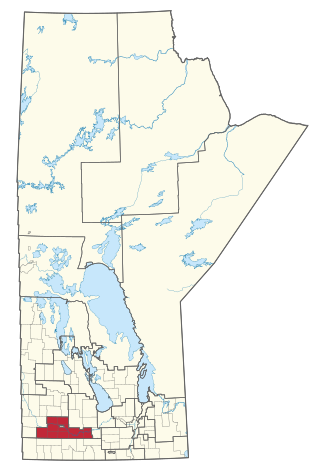
Division No. 7 is a census division located within the Westman Region in the south western area of the province of Manitoba, Canada. Unlike in some other provinces, census divisions do not reflect the organization of local government in Manitoba. These areas exist solely for the purposes of statistical analysis and presentation; they have no government of their own.

The Rural Municipality of Coldwell is a rural municipality in the Interlake Region of the province of Manitoba in Western Canada. The principal community within the boundaries is Lundar.

The Rural Municipality of North Cypress is a former rural municipality (RM) in the Canadian province of Manitoba. It was originally incorporated as a rural municipality on January 1, 1883. It ceased on January 1, 2015 as a result of its provincially mandated amalgamation with the RM of Langford to form the Municipality of North Cypress – Langford.

Ninette is an unincorporated community recognized as a local urban district located in Manitoba, Canada at the north end of Pelican Lake. It is located in the Rural Municipality of Prairie Lakes. Ninette has many small businesses, and is known locally for its wide range of sports facilities. In the summer, activities such as boating, fishing, and hunting are offered, while snowmobiling and ice fishing are offered during the wintertime.
The Rural Municipality of South Cypress is a former rural municipality (RM) in the Canadian province of Manitoba. It was originally incorporated as a rural municipality on December 22, 1883. It ceased on January 1, 2015 as a result of its provincially mandated amalgamation with the Village of Glenboro to form the Municipality of Glenboro – South Cypress.
Rathwell is an unincorporated urban centre in the province of Manitoba. It is part of the agricultural area of south central Manitoba, Canada and is situated in the Municipality of Norfolk Treherne.
Spruce Woods is a provincial electoral division in the Canadian province of Manitoba. It was created by redistribution in 2008 out of parts of Minnedosa and Turtle Mountain and notably gained parts of the City of Brandon and Arthur-Virden in the 2018 redistribution.

