Czerwone Stogi

Last updated
Czerwone Stogi
Village
Poland adm location map.svg
Red pog.svg
Czerwone Stogi
Coordinates: 54°2′51″N19°1′33″E / 54.04750°N 19.02583°E / 54.04750; 19.02583
Country Flag of Poland.svg Poland
Voivodeship Pomeranian
County Malbork
Gmina Gmina Malbork
Population 100

Czerwone Stogi [t͡ʂɛrˈvɔnɛ ˈstɔɡi] is a village in the administrative district of Gmina Malbork, within Malbork County, Pomeranian Voivodeship, in northern Poland. [1] It lies approximately 2 kilometres (1 mi) north of Malbork and 44 km (27 mi) south-east of the regional capital Gdańsk.

Village Small clustered human settlement smaller than a town

A village is a clustered human settlement or community, larger than a hamlet but smaller than a town, with a population ranging from a few hundred to a few thousand. Though villages are often located in rural areas, the term urban village is also applied to certain urban neighborhoods. Villages are normally permanent, with fixed dwellings; however, transient villages can occur. Further, the dwellings of a village are fairly close to one another, not scattered broadly over the landscape, as a dispersed settlement.

Gmina Malbork is a rural gmina in Malbork County, Pomeranian Voivodeship, in northern Poland. Its seat is in the town of Malbork, although the town is not part of the territory of the gmina. Malbork is also the administrative seat or capital of Malbork County.

Malbork County County in Pomeranian, Poland

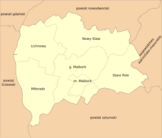
Malbork County is a unit of territorial administration and local government (powiat) in Pomeranian Voivodeship, northern Poland. It came into being on January 1, 1999, as a result of the Polish local government reforms passed in 1998. Its administrative seat and largest town is Malbork, 46 kilometres (29 mi) south-east of the regional capital Gdańsk. The only other town in the county is Nowy Staw, lying 12 km (7 mi) north of Malbork. Until 2002, the county also included the areas which now make up Sztum County.

Before 1772 the area was part of Kingdom of Poland, 1772-1919 Prussia and Germany, 1920-1939 Free City of Danzig, September 1939 - February 1945 Nazi Germany. For the history of the region, see History of Pomerania .

First Partition of Poland

The First Partition of Poland took place in 1772 as the first of three partitions that ended the existence of the Polish–Lithuanian Commonwealth by 1795. Growth in the Russian Empire's power, threatening the Kingdom of Prussia and the Habsburg Monarchy, was the primary motive behind this first partition. Frederick the Great engineered the partition to prevent Austria, jealous of Russian successes against the Ottoman Empire, from going to war. The weakened Commonwealth's land, including what was already controlled by Russia, was apportioned among its more powerful neighbors—Austria, Russia and Prussia—so as to restore the regional balance of power in Central Europe among those three countries. With Poland unable to effectively defend itself, and with foreign troops already inside the country, the Polish parliament (Sejm) ratified the partition in 1773 during the Partition Sejm convened by the three powers.

Crown of the Kingdom of Poland

The Crown of the Kingdom of Poland, commonly known as the Polish Crown, or, simply, the Crown, is the common name for the historic Late Middle Ages territorial possessions of the King of Poland, including Poland proper. The Polish Crown was at the helm of the Polish–Lithuanian Commonwealth from 1569 to 1795.

Free City of Danzig semi-autonomous city-state that existed between 1920 and 1939

The Free City of Danzig was a semi-autonomous city-state that existed between 1920 and 1939, consisting of the Baltic Sea port of Danzig and nearly 200 towns and villages in the surrounding areas. It was created on 15 November 1920 in accordance with the terms of Article 100 of the 1919 Treaty of Versailles after the end of World War I.

The village has a population of 100.

Related Research Articles

Gajewo, Pomeranian Voivodeship Village in Pomeranian, Poland

Gajewo is a village in the administrative district of Gmina Malbork, within Malbork County, Pomeranian Voivodeship, in northern Poland. It lies approximately 6 kilometres (4 mi) north of Malbork and 43 km (27 mi) south-east of the regional capital Gdańsk.

Grobelno, Poland Village in Pomeranian, Poland

Grobelno is a village in the administrative district of Gmina Malbork, within Malbork County, Pomeranian Voivodeship, in northern Poland. It lies approximately 2 kilometres (1 mi) west of Malbork and 45 km (28 mi) south-east of the regional capital Gdańsk.

Kałdowo-Wieś Village in Pomeranian, Poland

Kałdowo-Wieś is a village in the administrative district of Gmina Malbork, within Malbork County, Pomeranian Voivodeship, in northern Poland. It lies approximately 2 kilometres (1 mi) north of Malbork and 44 km (27 mi) south-east of the regional capital Gdańsk.

Kamienica, Pomeranian Voivodeship Village in Pomeranian, Poland

Kamienica is a village in the administrative district of Gmina Malbork, within Malbork County, Pomeranian Voivodeship, in northern Poland. It lies approximately 3 kilometres (2 mi) north-east of Malbork and 46 km (29 mi) south-east of the regional capital Gdańsk.

Kamionka, Malbork County Village in Pomeranian, Poland

Kamionka is a village in the administrative district of Gmina Malbork, within Malbork County, Pomeranian Voivodeship, in northern Poland. It lies approximately 3 kilometres (2 mi) north-east of Malbork and 44 km (27 mi) south-east of the regional capital Gdańsk.

Kościeleczki Village in Pomeranian, Poland

Kościeleczki is a village in the administrative district of Gmina Malbork, within Malbork County, Pomeranian Voivodeship, in northern Poland. It lies approximately 4 kilometres (2 mi) north of Malbork and 42 km (26 mi) south-east of the regional capital Gdańsk.

Lasowice Małe, Pomeranian Voivodeship Village in Pomeranian, Poland

Lasowice Małe is a village in the administrative district of Gmina Malbork, within Malbork County, Pomeranian Voivodeship, in northern Poland. It lies approximately 10 kilometres (6 mi) north-east of Malbork and 43 km (27 mi) south-east of the regional capital Gdańsk.

Lasowice Wielkie, Pomeranian Voivodeship Village in Pomeranian, Poland

Lasowice Wielkie is a village in the administrative district of Gmina Malbork, within Malbork County, Pomeranian Voivodeship, in northern Poland. It lies approximately 7 kilometres (4 mi) north-east of Malbork and 43 km (27 mi) south-east of the regional capital Gdańsk.

Pielica Village in Pomeranian, Poland

Pielica is a village in the administrative district of Gmina Malbork, within Malbork County, Pomeranian Voivodeship, in northern Poland. It lies approximately 6 kilometres (4 mi) north-east of Malbork and 45 km (28 mi) south-east of the regional capital Gdańsk.

Stogi, Pomeranian Voivodeship Village in Pomeranian, Poland

Stogi is a village in the administrative district of Gmina Malbork, within Malbork County, Pomeranian Voivodeship, in northern Poland. It lies approximately 7 kilometres (4 mi) north-west of Malbork and 40 km (25 mi) south-east of the regional capital Gdańsk. It is known for its historical Mennonite cemetery founded by Olędrzy, people of Dutch or German ancestry who settled Poland hundreds of years ago.

Szawałd Village in Pomeranian, Poland

Szawałd is a village in the administrative district of Gmina Malbork, within Malbork County, Pomeranian Voivodeship, in northern Poland. It lies approximately 7 kilometres (4 mi) north-east of Malbork and 47 km (29 mi) south-east of the regional capital Gdańsk.

Tragamin Village in Pomeranian, Poland

Tragamin is a village in the administrative district of Gmina Malbork, within Malbork County, Pomeranian Voivodeship, in northern Poland. It lies approximately 6 kilometres (4 mi) north of Malbork and 42 km (26 mi) south-east of the regional capital Gdańsk.

Brzózki, Pomeranian Voivodeship Village in Pomeranian, Poland

Brzózki is a village in the administrative district of Gmina Nowy Staw, within Malbork County, Pomeranian Voivodeship, in northern Poland. It lies approximately 5 kilometres (3 mi) north of Nowy Staw, 16 km (10 mi) north of Malbork, and 34 km (21 mi) south-east of the regional capital Gdańsk.

Chlebówka Village in Pomeranian, Poland

Chlebówka is a village in the administrative district of Gmina Nowy Staw, within Malbork County, Pomeranian Voivodeship, in northern Poland. It lies approximately 3 kilometres (2 mi) east of Nowy Staw, 12 km (7 mi) north of Malbork, and 38 km (24 mi) south-east of the regional capital Gdańsk.

Dębina, Malbork County Village in Pomeranian, Poland

Dębina is a village in the administrative district of Gmina Nowy Staw, within Malbork County, Pomeranian Voivodeship, in northern Poland. It lies approximately 4 kilometres (2 mi) south-east of Nowy Staw, 9 km (6 mi) north of Malbork, and 39 km (24 mi) south-east of the regional capital Gdańsk.

Laski, Malbork County Village in Pomeranian, Poland

Laski is a village in the administrative district of Gmina Nowy Staw, within Malbork County, Pomeranian Voivodeship, in northern Poland. It lies approximately 2 kilometres (1 mi) south-west of Nowy Staw, 10 km (6 mi) north of Malbork, and 37 km (23 mi) south-east of the regional capital Gdańsk.

Lubiszewo Drugie Village in Pomeranian, Poland

Lubiszewo Drugie is a village in the administrative district of Gmina Nowy Staw, within Malbork County, Pomeranian Voivodeship, in northern Poland. It lies approximately 3 kilometres (2 mi) north of Nowy Staw, 14 km (9 mi) north of Malbork, and 35 km (22 mi) south-east of the regional capital Gdańsk.

Martąg Village in Pomeranian, Poland

Martąg is a village in the administrative district of Gmina Nowy Staw, within Malbork County, Pomeranian Voivodeship, in northern Poland. It lies approximately 5 kilometres (3 mi) south-east of Nowy Staw, 8 km (5 mi) north of Malbork, and 41 km (25 mi) south-east of the regional capital Gdańsk.

Mirowo, Pomeranian Voivodeship Village in Pomeranian, Poland

Mirowo is a village in the administrative district of Gmina Nowy Staw, within Malbork County, Pomeranian Voivodeship, in northern Poland. It lies approximately 3 kilometres (2 mi) north-east of Nowy Staw, 14 km (9 mi) north of Malbork, and 36 km (22 mi) south-east of the regional capital Gdańsk.

Tralewo, Malbork County Village in Pomeranian, Poland

Tralewo is a village in the administrative district of Gmina Nowy Staw, within Malbork County, Pomeranian Voivodeship, in northern Poland. It lies approximately 4 kilometres (2 mi) south of Nowy Staw, 9 km (6 mi) north of Malbork, and 38 km (24 mi) south-east of the regional capital Gdańsk.

References


Coordinates: 54°2′51″N19°1′33″E / 54.04750°N 19.02583°E / 54.04750; 19.02583

Geographic coordinate system Coordinate system

A geographic coordinate system is a coordinate system that enables every location on Earth to be specified by a set of numbers, letters or symbols. The coordinates are often chosen such that one of the numbers represents a vertical position and two or three of the numbers represent a horizontal position; alternatively, a geographic position may be expressed in a combined three-dimensional Cartesian vector. A common choice of coordinates is latitude, longitude and elevation. To specify a location on a plane requires a map projection.