Lipki, Malbork County

Last updated
Lipki
Settlement
Poland adm location map.svg
Red pog.svg
Lipki
Coordinates: 54°0′22″N19°4′18″E / 54.00611°N 19.07167°E / 54.00611; 19.07167
Country Flag of Poland.svg Poland
Voivodeship Pomeranian
County Malbork
Gmina Gmina Malbork
Population 380

Lipki [ˈlipki] is a settlement in the administrative district of Gmina Malbork, within Malbork County, Pomeranian Voivodeship, in northern Poland. [1] It lies approximately 4 kilometres (2 mi) south-east of Malbork and 50 km (31 mi) south-east of the regional capital Gdańsk.

Human settlement Community of any size, in which people live

In geography, statistics and archaeology, a settlement, locality or populated place is a community in which people live. The complexity of a settlement can range from a small number of dwellings grouped together to the largest of cities with surrounding urbanized areas. Settlements may include hamlets, villages, towns and cities. A settlement may have known historical properties such as the date or era in which it was first settled, or first settled by particular people.

Gmina Malbork is a rural gmina in Malbork County, Pomeranian Voivodeship, in northern Poland. Its seat is in the town of Malbork, although the town is not part of the territory of the gmina. Malbork is also the administrative seat or capital of Malbork County.

Malbork County County in Pomeranian, Poland

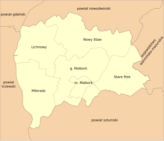
Malbork County is a unit of territorial administration and local government (powiat) in Pomeranian Voivodeship, northern Poland. It came into being on January 1, 1999, as a result of the Polish local government reforms passed in 1998. Its administrative seat and largest town is Malbork, 46 kilometres (29 mi) south-east of the regional capital Gdańsk. The only other town in the county is Nowy Staw, lying 12 km (7 mi) north of Malbork. Until 2002, the county also included the areas which now make up Sztum County.

Between the end of the 13th century and the 15th, the village lay in the territory of the Teutonic Knights. From 1466 until the First Partition of Poland, it was part of the Kingdom of Poland. After the partition, the region was part of Kingdom of Prussia and later the German Empire and Nazi Germany. In 1945 it became part of Poland again.

First Partition of Poland 1772 event

The First Partition of Poland took place in 1772 as the first of three partitions that ended the existence of the Polish–Lithuanian Commonwealth by 1795. Growth in the Russian Empire's power, threatening the Kingdom of Prussia and the Habsburg Monarchy, was the primary motive behind this first partition. Frederick the Great engineered the partition to prevent Austria, jealous of Russian successes against the Ottoman Empire, from going to war. The weakened Commonwealth's land, including what was already controlled by Russia, was apportioned among its more powerful neighbors—Austria, Russia and Prussia—so as to restore the regional balance of power in Central Europe among those three countries. With Poland unable to effectively defend itself, and with foreign troops already inside the country, the Polish parliament (Sejm) ratified the partition in 1773 during the Partition Sejm convened by the three powers.

Crown of the Kingdom of Poland

The Crown of the Kingdom of Poland, commonly known as the Polish Crown, or, simply, the Crown, is the common name for the historic Late Middle Ages territorial possessions of the King of Poland, including Poland proper. The Polish Crown was at the helm of the Polish–Lithuanian Commonwealth from 1569 to 1795.

Kingdom of Prussia Former German state (1701–1918)

The Kingdom of Prussia was a German kingdom that constituted the state of Prussia between 1701 and 1918. It was the driving force behind the unification of Germany in 1871 and was the leading state of the German Empire until its dissolution in 1918. Although it took its name from the region called Prussia, it was based in the Margraviate of Brandenburg, where its capital was Berlin.

The settlement has a population of 380.

Related Research Articles

Stożki, Pomeranian Voivodeship Settlement in Pomeranian, Poland

Stożki is a settlement in the administrative district of Gmina Lichnowy, within Malbork County, Pomeranian Voivodeship, in northern Poland. It lies approximately 4 kilometres (2 mi) south-east of Lichnowy, 9 km (6 mi) north-west of Malbork, and 37 km (23 mi) south-east of the regional capital Gdańsk.

Tropiszewo Village in Pomeranian, Poland

Tropiszewo is a village in the administrative district of Gmina Lichnowy, within Malbork County, Pomeranian Voivodeship, in northern Poland. It lies approximately 4 kilometres (2 mi) south-east of Lichnowy, 9 km (6 mi) north-west of Malbork, and 37 km (23 mi) south-east of the regional capital Gdańsk.

Gajewo, Pomeranian Voivodeship Village in Pomeranian, Poland

Gajewo is a village in the administrative district of Gmina Malbork, within Malbork County, Pomeranian Voivodeship, in northern Poland. It lies approximately 6 kilometres (4 mi) north of Malbork and 43 km (27 mi) south-east of the regional capital Gdańsk.

Grajewo Trzecie Settlement in Pomeranian, Poland

Grajewo Trzecie is a settlement in the administrative district of Gmina Malbork, within Malbork County, Pomeranian Voivodeship, in northern Poland. It lies approximately 5 kilometres (3 mi) north-east of Malbork and 44 km (27 mi) south-east of the regional capital Gdańsk.

Kamienica, Pomeranian Voivodeship Village in Pomeranian, Poland

Kamienica is a village in the administrative district of Gmina Malbork, within Malbork County, Pomeranian Voivodeship, in northern Poland. It lies approximately 3 kilometres (2 mi) north-east of Malbork and 46 km (29 mi) south-east of the regional capital Gdańsk.

Kamienice Settlement in Pomeranian, Poland

Kamienice is a settlement in the administrative district of Gmina Malbork, within Malbork County, Pomeranian Voivodeship, in northern Poland. It lies approximately 5 kilometres (3 mi) north-east of Malbork and 46 km (29 mi) south-east of the regional capital Gdańsk.

Lasowice Wielkie, Pomeranian Voivodeship Village in Pomeranian, Poland

Lasowice Wielkie is a village in the administrative district of Gmina Malbork, within Malbork County, Pomeranian Voivodeship, in northern Poland. It lies approximately 7 kilometres (4 mi) north-east of Malbork and 43 km (27 mi) south-east of the regional capital Gdańsk.

Nowa Wieś Malborska Village in Pomeranian, Poland

Nowa Wieś Malborska is a village in the administrative district of Gmina Malbork, within Malbork County, Pomeranian Voivodeship, in northern Poland. It lies approximately 3 kilometres (2 mi) south-east of Malbork and 49 km (30 mi) south-east of the regional capital Gdańsk.

Pielica Village in Pomeranian, Poland

Pielica is a village in the administrative district of Gmina Malbork, within Malbork County, Pomeranian Voivodeship, in northern Poland. It lies approximately 6 kilometres (4 mi) north-east of Malbork and 45 km (28 mi) south-east of the regional capital Gdańsk.

Sadowo Pierwsze Settlement in Pomeranian, Poland

Sadowo Pierwsze is a settlement in the administrative district of Gmina Malbork, within Malbork County, Pomeranian Voivodeship, in northern Poland. It lies approximately 7 kilometres (4 mi) north-east of Malbork and 47 km (29 mi) south-east of the regional capital Gdańsk.

Szawałd Village in Pomeranian, Poland

Szawałd is a village in the administrative district of Gmina Malbork, within Malbork County, Pomeranian Voivodeship, in northern Poland. It lies approximately 7 kilometres (4 mi) north-east of Malbork and 47 km (29 mi) south-east of the regional capital Gdańsk.

Tragamin Village in Pomeranian, Poland

Tragamin is a village in the administrative district of Gmina Malbork, within Malbork County, Pomeranian Voivodeship, in northern Poland. It lies approximately 6 kilometres (4 mi) north of Malbork and 42 km (26 mi) south-east of the regional capital Gdańsk.

Wielbark, Pomeranian Voivodeship Village in Pomeranian, Poland

Wielbark is a village in the administrative district of Gmina Malbork, within Malbork County, Pomeranian Voivodeship, in northern Poland. It lies approximately 5 kilometres (3 mi) south-west of Malbork, and is 48 km (30 mi) south-east of the regional capital Gdańsk. The village has a population of 103.

Stara Wisła Village in Pomeranian, Poland

Stara Wisła is a village in the administrative district of Gmina Miłoradz, within Malbork County, Pomeranian Voivodeship, in northern Poland. It lies approximately 8 kilometres (5 mi) north-west of Miłoradz, 13 km (8 mi) west of Malbork, and 36 km (22 mi) south-east of the regional capital Gdańsk.

Dębina, Malbork County Village in Pomeranian, Poland

Dębina is a village in the administrative district of Gmina Nowy Staw, within Malbork County, Pomeranian Voivodeship, in northern Poland. It lies approximately 4 kilometres (2 mi) south-east of Nowy Staw, 9 km (6 mi) north of Malbork, and 39 km (24 mi) south-east of the regional capital Gdańsk.

Dybowo, Pomeranian Voivodeship Settlement in Pomeranian, Poland

Dybowo is a settlement in the administrative district of Gmina Nowy Staw, within Malbork County, Pomeranian Voivodeship, in northern Poland. It lies approximately 2 kilometres (1 mi) south of Nowy Staw, 10 km (6 mi) north of Malbork, and 38 km (24 mi) south-east of the regional capital Gdańsk.

Krzewiny, Pomeranian Voivodeship Settlement in Pomeranian, Poland

Krzewiny is a settlement in the administrative district of Gmina Nowy Staw, within Malbork County, Pomeranian Voivodeship, in northern Poland. It lies approximately 14 kilometres (9 mi) east of Nowy Staw, 17 km (11 mi) north-east of Malbork, and 46 km (29 mi) south-east of the regional capital Gdańsk.

Myszewo Village in Pomeranian, Poland

Myszewo is a village in the administrative district of Gmina Nowy Staw, within Malbork County, Pomeranian Voivodeship, in northern Poland. It lies approximately 10 kilometres (6 mi) east of Nowy Staw, 14 km (9 mi) north-east of Malbork, and 44 km (27 mi) south-east of the regional capital Gdańsk.

Tralewo, Malbork County Village in Pomeranian, Poland

Tralewo is a village in the administrative district of Gmina Nowy Staw, within Malbork County, Pomeranian Voivodeship, in northern Poland. It lies approximately 4 kilometres (2 mi) south of Nowy Staw, 9 km (6 mi) north of Malbork, and 38 km (24 mi) south-east of the regional capital Gdańsk.

Złotowo, Malbork County Village in Pomeranian, Poland

Złotowo is a village in the administrative district of Gmina Stare Pole, within Malbork County, Pomeranian Voivodeship, in northern Poland. It lies approximately 4 kilometres (2 mi) south-east of Stare Pole, 14 km (9 mi) east of Malbork, and 54 km (34 mi) south-east of the regional capital Gdańsk.

References


Coordinates: 54°0′22″N19°4′18″E / 54.00611°N 19.07167°E / 54.00611; 19.07167

Geographic coordinate system Coordinate system

A geographic coordinate system is a coordinate system that enables every location on Earth to be specified by a set of numbers, letters or symbols. The coordinates are often chosen such that one of the numbers represents a vertical position and two or three of the numbers represent a horizontal position; alternatively, a geographic position may be expressed in a combined three-dimensional Cartesian vector. A common choice of coordinates is latitude, longitude and elevation. To specify a location on a plane requires a map projection.