The Vercors massif are a range in France consisting of rugged plateaus and mountains straddling the départements of Isère and Drôme in the French Prealps. It lies west of the Dauphiné Alps, from which it is separated by the rivers Drac and Isère. The cliffs at the massif's eastern limit face the city of Grenoble.

Pillar is a mountain in the western part of the English Lake District. Situated between the valleys of Ennerdale to the north and Wasdale to the south, it is the highest point of the Pillar group. At 892 metres (2,927 ft) it is the eighth-highest mountain in the Lake District. The fell takes its name from Pillar Rock, a prominent feature on the Ennerdale side, regarded as the birthplace of rock climbing in the district.

Realization, also called Biographie, is a circa 35-metre (115 ft) sport climbing route on a limestone cliff on the southern face of Céüse mountain, near Gap and Sigoyer, in France. After it was first climbed in 2001 by American climber Chris Sharma, it became the first rock climb in the world to have a consensus grade of 9a+ (5.15a). It is considered an historic and important route in rock climbing, and one of the most attempted climbs at its grade.

Fair Head or Benmore is a 5-kilometre (3.1 mi) long, 200-metre (660 ft) high, mountain cliff, close to the sea, at the north-eastern corner of County Antrim, Northern Ireland. The cliff's sheer and vertical 100-metre (330 ft) high dolerite rock face is shaped into distinctive vertical columns like organ pipes, which formed 60 million years ago when a sill of igneous rock was injected between horizontal Carboniferous sediments.

Jean-Christophe Lafaille was a French climber noted for a number of difficult ascents in the Alps and Himalaya, and for what has been described as "perhaps the finest self-rescue ever performed in the Himalaya", when he was forced to descend the mile-high south face of Annapurna alone with a broken arm, after his climbing partner had been killed in a fall. He climbed eleven of the fourteen eight-thousanders, many of them alone or by previously unclimbed routes, but disappeared during a solo attempt to make the first winter ascent of Makalu, the world's fifth highest mountain.

Mweelrea is a mountain on the Atlantic coast of County Mayo, Ireland. Rising to 814 metres (2,671 ft), it is the highest mountain in the western province of Connacht, and is noted for its southeastern cliff-lined corries, and its views. Mweelrea overlooks Killary Harbour and is at the heart of a "horseshoe-shaped" massif that includes the peaks of Ben Lugmore and Ben Bury. The massif is called the Mweelrea Mountains or the Mweelrea Range.

Clogwyn Du'r Arddu, is a north-facing rhyolite set of cliffs located on the northern flank of Snowdon mountain. Clogwyn Du'r Arddu is considered to be one of the best traditional climbing areas in Britain, and has been called "The shrine of British climbing", and a "crucible for the development of most of the finest climbers in Britain and the scene of many of their finest achievements".

Coma Pedrosa is the highest mountain in the principality of Andorra. It is popular with mountain climbers, its ascent being technically straightforward, although strenuous. From Arinsal to Camp de Refuge is considered moderate meanwhile the last 862 m is considered to be difficult. Several mountain lakes and tarns are found on the slopes, notably Estanys de Baiau, which lies on the western slopes, across the Spanish border.

Buoux [bju̟ːks] is a commune in the Vaucluse department in the Provence-Alpes-Côte d'Azur region in southeastern France.

Hopegill Head is a fell in the English Lake District in Cumbria. It is located nine kilometres west of the town of Keswick and is well seen from the B5292 road which crosses the Whinlatter Pass.

The Gap of Dunloe, also recorded as Bearna an Choimín, is a narrow mountain pass running north–south in County Kerry, Ireland, that separates the MacGillycuddy's Reeks mountain range in the west, from the Purple Mountain Group range in the east. It is one of Kerry's most popular tourist destinations on account of its scenery.

Ailladie, is an 800-metre-long (2,600 ft) west-facing limestone sea cliff, that varies in height from 8 metres (26 ft) to 35 metres (115 ft), situated on the coast of The Burren in County Clare, Ireland. Ailladie is one of Ireland's most highly regarded rock-climbing locations, particularly for high technical grade single pitch traditional climbing routes and deep-water soloing routes. It is also a location for shore-angling competitions, and, with its cliffs and view of the Aran Islands, is a popular photography stop for tourists.
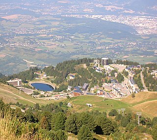
Chamrousse is a ski resort in Southeastern France, in the Belledonne mountain range near Grenoble in the Isère department. It is located in a commune of the same name and is situated on the Recoin at 1,650 m (5,413 ft) and the Roche Béranger at 1,750 m (5,741 ft). The ski-lifts reach the Cross of Chamrousse at 2,253 m (7,392 ft).

Sixt-Fer-à-Cheval is a commune in the Haute-Savoie department within the Auvergne-Rhône-Alpes region in southeastern France. It is located at the end of the Giffre Valley.

La Rambla is a 41-metre (135 ft) sport climb at the limestone El Pati crag in Siurana, Catalonia in Spain. Originally bolted and climbed by Alexander Huber in 1994 as a 35-metre (115 ft) route, the bolting was later extended by Dani Andrada to a 41-metre (135 ft) route, which was eventually climbed by Ramón Julián Puigblanque in 2003. While there has been debate about La Rambla's grade, there is now consensus that it meets the 9a+ (5.15a) threshold. It is an important and historic route in climbing, and is part of the coveted "9a+ trilogy" with Realization and Papichulo.

Craig y Forwyn is a crag in Conwy County Borough, Wales, located less than a mile south of Llanddulas, near the village of Rhyd y Foel. The cliff is composed of carboniferous limestone and is of interest to geologists as a source of fossils and to rock climbers as a fine cliff with many interesting climbing routes.

La Dura Dura is a 50-metre (160 ft) sport climbing route on the multi-coloured limestone cliffs known as the Contrafort de Rumbau, which are part of the Roc de Rumbau mountain, that lies in Oliana, Spain. The route was bolted and developed by American climber Chris Sharma in 2009 who had almost given up believing he could climb it until a collaboration with Czech climber Adam Ondra led to Ondra climbing the route on 7 February 2013, followed by Sharma on 23 March 2013.

Ben Lugmore at 803 metres (2,635 ft) is the 29th-highest peak in Ireland on the Arderin scale, and the 37th-highest peak on the Vandeleur-Lynam scale. It is in a horseshoe-shaped massif that includes the slightly higher peak of Mweelrea at 814 metres (2,671 ft), the highest mountain in the Irish province of Connacht. The massif is between Killary Harbour and Doo Lough, in County Mayo.
Bibliographie is a circa 35-metre (115 ft) sport climbing route on a limestone cliff on the southern face of Céüse mountain, near Gap and Sigoyer, in France. The route was bolted in 2009 by Ethan Pringle, and was first ascended by Alexander Megos on 5 August 2020. Megos initially graded the route as 9c (5.15d), the highest difficulty at that time. The route was repeated on 24 August 2021 by Stefano Ghisolfi, who graded the route as 9b+ (5.15c), which has become the consensus grade for Bibliographie, making it only the fifth-ever climb in history at a grade of 9b+.

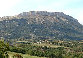
Céüze 2000 is a winter sports resort located on the mountain of Céüse in the commune of Manteyer in the Hautes-Alpes department and Provence-Alpes-Côte d'Azur region of France.