A weather satellite or meteorological satellite is a type of Earth observation satellite that is primarily used to monitor the weather and climate of the Earth. Satellites can be polar orbiting, or geostationary.

The Blue Marble is a photograph of Earth taken on December 7, 1972, from a distance of around 29,400 km (18,300 mi) from Earth's surface.

Gravity-gradient stabilization or tidal stabilization is a passive method of stabilizing artificial satellites or space tethers in a fixed orientation using only the mass distribution of the orbited body and the gravitational field. The main advantage over using active stabilization with propellants, gyroscopes or reaction wheels is the low use of power and resources. It can also reduce or prevent the risk of propellant contamination of sensitive components.

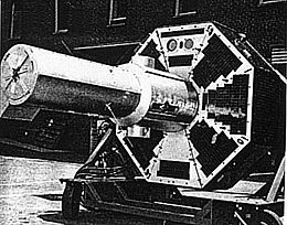
ATS-6 was a NASA experimental satellite, built by Fairchild Space and Electronics Division It has been called the world's first educational satellite as well as world's first experimental Direct Broadcast Satellite as part of the Satellite Instructional Television Experiment between NASA and Indian Space Research Organisation (ISRO). It was launched May 30, 1974, and decommissioned July 1979. At the time of launch, it was the most powerful telecommunication satellite in orbit. ATS-6 carried no fewer than 23 different experiments, and introduced several breakthroughs. It was the first 3-axis stabilized spacecraft in geostationary orbit. It was also the first to use experimentally with some success electric propulsion in geostationary orbit. It also carried several particle physics experiments, including the first heavy ion detector in geostationary orbit.
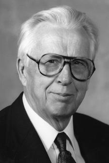
Verner Edward Suomi was a Finnish-American educator, inventor, and scientist. He is considered the father of satellite meteorology. He invented the Spin Scan Radiometer, which for many years was the instrument on the GOES weather satellites that generated the time sequences of cloud images seen on television weather shows. The Suomi NPP polar orbiting satellite, launched in 2011, was named in his honor.
The Applications Technology Satellites (ATS) were a series of experimental satellites launched by NASA, under the supervision of, among others, Wernher von Braun. The program was launched in 1966 to test the feasibility of placing a satellite into geosynchronous orbit. The satellites were primarily designed to act as communication satellites, but also carried equipment related to meteorology and navigation. ATS-6 was the world's first educational satellite as well as world's first experimental Direct Broadcast Satellite (DBS) as part of the Satellite Instructional Television Experiment (SITE) between NASA and ISRO.
Applications Technology Satellite 3, or ATS-3, was a long-lived American experimental geostationary weather and communications satellite, operated by NASA from 1967 to 2001. It was at one time reputed to be the oldest satellite still in operation. As of 1995, NASA referred to the ATS-3 as "The oldest active communications satellite by a wide margin."
McIDAS, the "Man computer Interactive Data Access System", is a weather forecasting tool developed at the University of Wisconsin–Madison in the 1970s and used continually to this day. In its early incarnations, it was widely used to generate graphics for television stations, but today is used primarily by the NOAA and related agencies. Users of the McIDAS system developed a similar version for microcomputers and sold by ColorGraphics Weather Systems that generated much of the computerized weather imagery seen on television in the US in the 1980s.
Kosmos 23, also known as Omega No.2, was a satellite which was launched by the Soviet Union in 1963. It was an Omega satellite, derived from the Dnepropetrovsk Sputnik series. It was a 347 kilograms (765 lb) spacecraft, which was built by the Yuzhnoye Design Office, and was used to conduct experiments with the use of gyroscopes to control spacecraft, for VNIIEM.
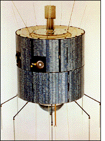
ATS-1, also designated ATS-B or Advanced Tech. Sat. 1, was an experimental geostationary satellite, launched in 1966. Though intended as a communications satellite rather than as a weather satellite, it carried the Spin Scan Cloud Camera developed by Verner E. Suomi and Robert Parent at the University of Wisconsin. After entering an orbit at 23,000 mi (37,000 km) above Earth, initially in orbit over Ecuador, it transmitted weather images from the Western Hemisphere, as well as other data, to ground stations, including well as video feeds for television broadcasting.

Himawari 8 (ひまわり8号) is a Japanese weather satellite, the 8th of the Himawari geostationary weather satellites operated by the Japan Meteorological Agency. The spacecraft was constructed by Mitsubishi Electric with assistance from Boeing, and is the first of two similar satellites to be based on the DS2000 satellite bus. Himawari 8 entered operational service on 7 July 2015 and is the successor to MTSAT-2 which was launched in 2006.

Kosmos 122, launched on 25 June 1966, Meteor No.5L, and was one of eleven weather satellites put into orbit between 1964 and 1969.
Kosmos 144, was launched on 28 February 1967, Meteor No.6L, and was one of eleven weather satellites launched by the Soviet Union between 1964 and 1969. Kosmos 144 was the second announced Russian meteorological satellite and the first interim operational weather satellite in the experimental Kosmos satellite 'Meteor' system. It was also the first launch of the semi-operational weather satellite from the Plesetsk site into a near-polar, near-circular orbit. Unlike U.S. weather satellites, however, the orbit was prograde because, as a result of geographic limitations, a retrograde orbit was not possible. Kosmos 144 was orbited to test, in a semi-operational mode, meteorological instruments designed for obtaining images of cloud cover, snow cover, and ice fields on the day and night sides of the Earth and for measuring fluxes of outgoing radiation reflected and radiated by the Earth-atmosphere system.
Kosmos 156 was a Soviet weather satellite launched on 27 April 1967, one of eleven weather satellites launched by the Soviet Union between 1964 and 1969. It formed part of the experimental "Meteor" weather satellite system. In 1969, the Kosmos satellite series was scrapped for the more modern and updated Meteor satellite.

ATS-2 was a communications satellite launched by NASA on April 6, 1967, on an Atlas-Agena D rocket from Cape Canaveral.

ATS-4 also known as ATS-D was a communications satellite launched by NASA on August 10, 1968 from Cape Canaveral through an Atlas-Centaur rocket.
Himawari 9 is a Japanese weather satellite, the 9th of the Himawari geostationary weather satellite operated by the Japan Meteorological Agency. The spacecraft was constructed by Mitsubishi Electric, and is the second of two similar satellites to be based on the DS-2000 bus.

TIROS-8 was a spin-stabilized meteorological satellite. It was the eighth in a series of Television Infrared Observation Satellites.

Nimbus 4 was a meteorological satellite. It was the fourth in a series of the Nimbus program.
Photography and other imagery of planet Earth from outer space started in the 1940s, first from rockets in suborbital flight, subsequently from satellites around Earth, and then from spacecraft beyond Earth's orbit.