ATS-3

Last updated
ATS-3
Applications Technology Satellite 3 (ATS 3).png
ATS-3 prelaunch
Mission type Weather
Communications
Technology
Operator NASA
COSPAR ID 1967-111A OOjs UI icon edit-ltr-progressive.svg
SATCAT no. 3029
Mission duration34 years
Spacecraft properties
Bus HS-306
Manufacturer Hughes
Launch mass365.0 kilograms (804.7 lb)
Start of mission
Launch dateNovember 5, 1967, 23:37:00 (1967-11-05UTC23:37Z) UTC [1]
Rocket Atlas SLV-3 Agena-D
Launch site Cape Canaveral LC-12
End of mission
Deactivated2001 (2002)
Orbital parameters
Reference system Geocentric
Regime GSO
Semi-major axis 42,241.0 kilometres (26,247.3 mi)
Eccentricity 0.00043
Perigee altitude 35,723 kilometers (22,197 mi)
Apogee altitude 35,862 kilometers (22,284 mi)
Inclination 6.92 degrees
Period 23.93 hours
Epoch January 21, 2014, 11:54:19 UTC [2]
 
NASA's first color photo (digital image mosaic) of Earth, imaged in 1967 by ATS-3, was used as the cover of Whole Earth Catalog's first edition. ATSIII 10NOV67 153107.jpg
NASA's first color photo (digital image mosaic) of Earth, imaged in 1967 by ATS-3, was used as the cover of Whole Earth Catalog 's first edition.

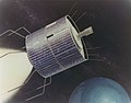
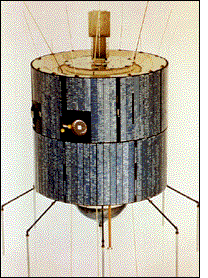
Applications Technology Satellite 3, or ATS-3, was a long-lived American experimental geostationary weather and communications satellite, operated by NASA from 1967 to 2001. [3] It was at one time reputed to be the oldest satellite still in operation. [4] As of 1995, NASA referred to the ATS-3 as "The oldest active communications satellite by a wide margin." [5]

Contents

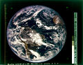
On November 10, 1967, ATS-3 took NASA's first color photo (digital image mosaic) of the full-disk Earth, which was subsequently used on the cover of the first Whole Earth Catalog .

History

Launched in November 1967, the ATS-3 was in service for 11 years before finally being decommissioned in 1978 along with ATS-1. [6] Among its widest-known achievements are the first full-disk, "true color" [7] composite Earth image (DODGE took color-filtered black-and-white images, put together they produced the very first color image of the full-disk). [8] Its imaging capability has served during disaster situations, from the Mexico earthquake to the Mount St. Helens eruption. [5]

ATS-3 experiments included VHF and C-band communications, a color spin-scan camera [9] (principally developed by Verner E. Suomi), an image dissector camera, a mechanically despun antenna, resistojet thrusters, hydrazine propulsion, optical surface experiments, and the measurement of the electron content of the ionosphere and magnetosphere.

Because of failures in the hydrogen peroxide systems on ATS-1, ATS-3 was equipped with a hydrazine propulsion system. Its success led to its incorporation on ATS-4 and ATS-5 as the sole propulsion system. [5]

Operational details

The satellite is in geo-synchronous orbit 34,047 kilometers (21,156 mi) above the Earth's surface. The satellite has served as a communications link for rescue operations, including the 1985 Mexico City earthquake and the 1980 eruption of Mount St. Helens. [10]

Circa 1970, ATS-3 was used to collect images of weather patterns, especially developing hurricanes in the Western Hemisphere. 1,200 line photos were downlinked, approximately every 25 minutes, during daylight hours to NOAA's Command and Data Acquisition Station at Wallops Station, Virginia and transferred to various users. The satellite was known for its spinning beam antennas locking up and rotating with the satellite. When that happened, it took a powerful ground-based transmitter, like the one at Mojave, to blast through digital instructions to get the antenna aimed back at earth again.[ citation needed ]

ATS-3 Ground Station Antenna ATS-3 Satellite VHF Ground Station Antenna.jpg
ATS-3 Ground Station Antenna

See also

Related Research Articles

<span class="mw-page-title-main">Geostationary orbit</span> Circular orbit above Earths Equator and following the direction of Earths rotation

A geostationary orbit, also referred to as a geosynchronous equatorial orbit (GEO), is a circular geosynchronous orbit 35,786 km (22,236 mi) in altitude above Earth's equator, 42,164 km (26,199 mi) in radius from Earth's center, and following the direction of Earth's rotation.

<span class="mw-page-title-main">Communications satellite</span> Artificial satellite that relays radio signals

A communications satellite is an artificial satellite that relays and amplifies radio telecommunication signals via a transponder; it creates a communication channel between a source transmitter and a receiver at different locations on Earth. Communications satellites are used for television, telephone, radio, internet, and military applications. Many communications satellites are in geostationary orbit 22,300 miles (35,900 km) above the equator, so that the satellite appears stationary at the same point in the sky; therefore the satellite dish antennas of ground stations can be aimed permanently at that spot and do not have to move to track the satellite. Others form satellite constellations in low Earth orbit, where antennas on the ground have to follow the position of the satellites and switch between satellites frequently.

<span class="mw-page-title-main">Weather satellite</span> Type of satellite designed to record the state of the Earths atmosphere

A weather satellite or meteorological satellite is a type of Earth observation satellite that is primarily used to monitor the weather and climate of the Earth. Satellites can be polar orbiting, or geostationary.

<i>Nozomi</i> (spacecraft) Failed Mars orbiter

Nozomi was a Mars orbiter that failed to reach Mars due to electrical failures. The mission was terminated on December 31, 2003.

<span class="mw-page-title-main">Communications Technology Satellite</span>

The Communications Technology Satellite (CTS), known as Hermes, was an experimental high-power direct broadcast communications satellite. It was a joint effort of Canadian Department of Communications, who designed and built the satellite, NASA who tested, launched and operated the satellite, and European Space Agency (ESA) who provided the 1200 watts solar panels and other devices. The three agencies shared the satellite and the data from the experiments.

<span class="mw-page-title-main">ATS-6</span> NASA experimental satellite

ATS-6 was a NASA experimental satellite, built by Fairchild Space and Electronics Division It has been called the world's first educational satellite as well as world's first experimental Direct Broadcast Satellite as part of the Satellite Instructional Television Experiment between NASA and Indian Space Research Organisation (ISRO). It was launched May 30, 1974, and decommissioned July 1979. At the time of launch, it was the most powerful telecommunication satellite in orbit. ATS-6 carried no fewer than 23 different experiments, and introduced several breakthroughs. It was the first 3-axis stabilized spacecraft in geostationary orbit. It was also the first to use experimentally with some success electric propulsion in geostationary orbit. It also carried several particle physics experiments, including the first heavy ion detector in geostationary orbit.

<span class="mw-page-title-main">Verner E. Suomi</span> Finnish-American educator, inventor, and scientist

Verner Edward Suomi was a Finnish-American educator, inventor, and scientist. He is considered the father of satellite meteorology. He invented the Spin Scan Radiometer, which for many years was the instrument on the GOES weather satellites that generated the time sequences of cloud images seen on television weather shows. The Suomi NPP polar orbiting satellite, launched in 2011, was named in his honor.

<span class="mw-page-title-main">Applications Technology Satellites</span> Series of experimental satellites launched by NASA

The Applications Technology Satellites (ATS) were a series of experimental satellites launched by NASA, under the supervision of, among others, Wernher von Braun. The program was launched in 1966 to test the feasibility of placing a satellite into geosynchronous orbit. The satellites were primarily designed to act as communication satellites, but also carried equipment related to meteorology and navigation. ATS-6 was the world's first educational satellite as well as world's first experimental Direct Broadcast Satellite (DBS) as part of the Satellite Instructional Television Experiment (SITE) between NASA and ISRO.

The Space Test Program (STP) is the primary provider of spaceflight for the United States Department of Defense (DoD) space science and technology community. STP is managed by a group within the Advanced Systems and Development Directorate, a directorate of the Space and Missile Systems Center of the United States Space Force. STP provides spaceflight via the International Space Station (ISS), piggybacks, secondary payloads and dedicated launch services.

<span class="mw-page-title-main">Lincoln Experimental Satellite</span> Experimental Satellite series for testing devices and techniques for satellite communication

The Lincoln Experimental Satellite series was designed and built by Lincoln Laboratory at Massachusetts Institute of Technology between 1965 and 1976, under USAF sponsorship, for testing devices and techniques for satellite communication.

McIDAS, the "Man computer Interactive Data Access System", is a weather forecasting tool developed at the University of Wisconsin–Madison in the 1970s and used continually to this day. In its early incarnations, it was widely used to generate graphics for television stations, but today is used primarily by the NOAA and related agencies. Users of the McIDAS system developed a similar version for microcomputers and sold by ColorGraphics Weather Systems that generated much of the computerized weather imagery seen on television in the US in the 1980s.

<span class="mw-page-title-main">Earth Observing-1</span>

Earth Observing-1 (EO-1) is a decommissioned NASA Earth observation satellite created to develop and validate a number of instrument and spacecraft bus breakthrough technologies. It was intended to enable the development of future Earth imaging observatories that will have a significant increase in performance while also having reduced cost and mass. The spacecraft was part of the New Millennium Program. It was the first satellite to map active lava flows from space; the first to measure a facility's methane leak from space; and the first to track re-growth in a partially logged Amazon forest from space. EO-1 captured scenes such as the ash after the World Trade Center attacks, the flooding in New Orleans after Hurricane Katrina, volcanic eruptions and a large methane leak in southern California.

<span class="mw-page-title-main">DODGE</span> Satellite

DODGE was a satellite whose primary purpose was to conduct experiments in gravity-gradient stabilization at near-geosynchronous altitudes. Its secondary objectives included measuring the Earth's magnetic field, and taking pictures of the entire Earth's disk in both black-and-white and color. It was launched atop a Titan IIIC rocket on July 1, 1967, and operated for over three years. DODGE carried ten knobbed booms oriented along three different axes, that could be independently extended and retracted by ground command.

<span class="mw-page-title-main">ATS-1</span> Communications and weather satellite

ATS-1 was the first experimental geostationary satellite, launched in 1966. Though intended as a communications satellite rather than as a weather satellite, it carried the Spin Scan Cloud Camera developed by Verner E. Suomi and Robert Parent at the University of Wisconsin. After entering an orbit at 23,000 mi (37,000 km) above Earth, initially in orbit over Ecuador, it transmitted weather images from the Western Hemisphere, as well as other data, to ground stations, including well as video feeds for television broadcasting. It took one of the first pictures of the Earth's full-disk, on December 11, 1966.

"For the first time," historians would note later, "rapid-imaging of nearly an entire hemisphere was possible. We could watch, fascinated, as storm systems developed and moved and were captured in a time series of images. Today such images are an indispensable part of weather analysis and forecasting."

<span class="mw-page-title-main">GOES-16</span> American geosynchronous environmental satellite

<span class="mw-page-title-main">Himawari 8</span> Japanese weather satellite

Himawari 8 (ひまわり8号) is a Japanese weather satellite, the 8th of the Himawari geostationary weather satellites operated by the Japan Meteorological Agency. The spacecraft was constructed by Mitsubishi Electric with assistance from Boeing, and is the first of two similar satellites to be based on the DS2000 satellite bus. Himawari 8 entered operational service on 7 July 2015 and is the successor to MTSAT-2 which was launched in 2006.

<span class="mw-page-title-main">Kosmos 122</span>

Kosmos 122, launched on 25 June 1966, Meteor No.5L, and was one of eleven weather satellites put into orbit between 1964 and 1969.

Kosmos 144, was launched on 28 February 1967, Meteor No.6L, and was one of eleven weather satellites launched by the Soviet Union between 1964 and 1969. Kosmos 144 was the second announced Russian meteorological satellite and the first interim operational weather satellite in the experimental Kosmos satellite 'Meteor' system. It was also the first launch of the semi-operational weather satellite from the Plesetsk site into a near-polar, near-circular orbit. Unlike U.S. weather satellites, however, the orbit was prograde because, as a result of geographic limitations, a retrograde orbit was not possible. Kosmos 144 was orbited to test, in a semi-operational mode, meteorological instruments designed for obtaining images of cloud cover, snow cover, and ice fields on the day and night sides of the Earth and for measuring fluxes of outgoing radiation reflected and radiated by the Earth-atmosphere system. The launch of the Kosmos 144 satellite occurred after the success of the Kosmos 122 another meteorological satellite that was launched on 25 June 1966. These satellites were used until 1969 when they were replaced with an upgraded model officially called Meteor 1. The Kosmos 144 differed from the Kosmos 122 mission from Baikonur Cosmodrome to Plesetsk Cosmodrome that was used to get the satellite at the inclination that the satellite was left. The Kosmos 144 was also soon joined by the Kosmos 156, on 27 April 1967, which due to the orbit at which the satellites were positioned made it to where one of the satellites would pass over every six hours.

<span class="mw-page-title-main">ATS-2</span> Communications satellite launched by NASA

ATS-2 was a communications satellite launched by NASA on April 6, 1967, on an Atlas-Agena D rocket from Cape Canaveral.

Photography and other imagery of planet Earth from outer space started in the 1940s, first from rockets in suborbital flight, subsequently from satellites around Earth, and then from spacecraft beyond Earth's orbit.

References

  1. McDowell, Jonathan. "Launch Log". Jonathan's Space Page. Retrieved January 24, 2014.
  2. "ATS 3 Satellite details 1967-111A NORAD 3029". N2YO. January 21, 2014. Retrieved January 24, 2014.
  3. "ATS | Science Mission Directorate". science.nasa.gov. Retrieved October 27, 2016.
  4. "Technology". solarstorms.org. Archived from the original on September 28, 2006. Retrieved November 17, 2012.
  5. 1 2 3 Glover, Daniel R. (1997). "Chapter 6: NASA Experimental Communications Satellites, 1958–1995, SP-4217 Beyond the Ionosphere". In Butrica, Andrew J. (ed.). Beyond The Ionosphere: The Development of Satellite Communications. NASA.
  6. "Applications Technology Satellite Program".
  7. Miller, Steven D.; Schmit, Timothy L.; Seaman, Curtis J.; Lindsey, Daniel T.; Gunshor, Mathew M.; Kohrs, Richard A.; Sumida, Yasuhiko; Hillger, Donald (October 1, 2016). "A Sight for Sore Eyes: The Return of True Color to Geostationary Satellites". Bulletin of the American Meteorological Society. American Meteorological Society. 97 (10): 1803–1816. Bibcode:2016BAMS...97.1803M. doi: 10.1175/bams-d-15-00154.1 . ISSN   0003-0007. S2CID   51994278.
  8. "The First Color Images of the Earth from Space". Geography Realm. March 13, 2019. Retrieved February 2, 2022.
  9. "NASA – NSSDC – Experiment – Details – Multicolor Spin-Scan Cloudcover Camera (MSSCC)". NASA . Retrieved November 17, 2012.
  10. Pae, Peter, "Satellites' Longevity Limits Sales", Los Angeles Times , December 1, 2008, p. C1.