DR-3

Last updated
DR-3 troncal.svg
DR-3
Expreso 27 de Febrero
Expreso de las Americas
Autopista De las Americas
Autovia del Este
Autopista El Coral
Major junctions
West endPlaza de la Bandera, Santo Domingo, DR
Major intersections DR-8 in Santo Domingo Este
DR-4 in San Pedro de Macorís
DR-4 in San Rafael del Yuma
East end San Rafael Del Yuma, DR
Location
Country Dominican Republic
Major cities Santo Domingo, Santo Domingo Este, Boca Chica, San Pedro de Macorís, San Rafael del Yuma, La Romana,
Highway system

DR-3 is one of three main dual carriageway highways of the Dominican Republic, connecting Santo Domingo to the eastern cities of the republic. The highway begins at the Plaza de La Bandera, on the western side of Santo Domingo, and travels eastward through downtown Santo Domingo and continues east to Santo Domingo Este. Outside Santo Domingo it runs roughly parallel to the Caribbean Sea toward the eastern cities of the nation. DR-3 creates a rapid connection to the Las Américas International Airport, located only 30 kilometers east of Santo Domingo. DR-3 continues eastward to the beach towns of Andrés and Boca Chica. DR-3 then continues east and slightly north to the eastern cities of San Pedro de Macorís, La Romana, and Higüey and has connections to the routes that lead to the resort towns of Bayahibe, Bávaro, and Punta Cana. DR-3 has been part of a long program to improve, expand, and modernize the highways of the Republic. Most of DR-3 has been expanded to two or three lanes of traffic each way.

Contents

Expreso 27 de Febrero Tunnel in Downtown Santo Domingo (Distrito Nacional) Tunnel27feb.jpg
Expreso 27 de Febrero Tunnel in Downtown Santo Domingo (Distrito Nacional)

Route description

DR-3 is called by different names from its western terminus in Plaza de la Bandera, Santo Domingo, Distrito Nacional to San Rafael del Yuma in the eastern corner of the country. It connects the capital of the country with the eastern region known for its heavily tourist oriented economy. DR-3 travels to the major cities of the east such as San Pedro De Macorís and La Romana and the tourist towns of Bávaro, Punta Cana and Bayahibe. Together with DR-4 it connects the east with the metropolitan area of Santo Domingo.

DR-3 Westbound after the Juan Bosch Bridge entering the National District through the 27 de Febrero Expressway segment (2017). DR-3 Entering the 27 de Febrero Expressway segment.jpg
DR-3 Westbound after the Juan Bosch Bridge entering the National District through the 27 de Febrero Expressway segment (2017).
DR-3 Westbound before the Juan Bosch Bridge after the East Santo Domingo Tunnel (2017). DR-3 Entering Bridge.jpg
DR-3 Westbound before the Juan Bosch Bridge after the East Santo Domingo Tunnel (2017).

Expreso 27 de Febrero/Expreso de las Americas

At the Plaza de la Bandera, DR-3 begins its run named Expreso 27 de Febrero through the downtown districts of Santo Domingo with a series of tunnels and underground passes, making it an important main avenue of the city. There is a kilometer-long tunnel that crosses below Winston Churchill and Abraham Lincoln avenues, and short tunnels crossing below Tiradentes and Maximo Gomez avenues. A T-interchange and a tunnel were completed at the Ortega y Gasset avenue in 2011. [1] It then continues its route east, also intersecting Maximo Gomez avenue, the main north–south thoroughfare of the city. The corridor continues east of downtown via the use of a single long grade-separated viaduct with exits that connect the expreso with the southern borders of working-class neighborhoods such as Miraflores, Villa Consuelo, and Mejoramiento Social. The viaduct continues above the San Martin, Juan Pablo Duarte, and Josefa Brea avenues of the city until its end in the Ozama River. As it reaches the border of the Distrito Nacional it crosses the Ozama River via the Juan Pablo Duarte and Prof. Juan Bosch bridges.

DR-3 continues through Santo Domingo Este, renamed as Expreso de Las Americas, with another kilometer-long tunnel below Venezuela and Sabana Larga avenues and a series of grade overpasses below intersections of San Vicente de Paul and San Isidro, with a T-interchange yet to be completed in Estados Unidos avenue. Slightly further east, the Expreso connects with the Charles de Gaulle beltway of the city. Expreso de Las Américas serves as the main urban corridor of Santo Domingo Este and serves as a rapid connection to Downtown and the Distrito Nacional where most of the jobs of the city are located.

DR-3 Autopista Las Americas segment. Sunset with part of downtown in the background. Sunset DR-3.jpg
DR-3 Autopista Las Americas segment. Sunset with part of downtown in the background.

Autopista de las Américas

After exiting the municipality of Santo Domingo Este, the highway becomes a limited-access highway and runs parallel to the Caribbean Sea with six lanes of highway and a two-way, four-lane service road on the north side. The highway also contains modern service stops in the median constructed for the 2003 Pan American Games. It provides a fast connection to Las Américas International Airport, the main airport serving Santo Domingo. Only 15 kilometers east of Greater Santo Domingo there is a toll booth for those entering the airport and traveling outside the bounds of the area. This section of the highway is one of the best in the country in terms of quality and has been improved several times since the 2003 Pan American Games. The portion from Santo Domingo Este to here is also the only true limited-access highway in the country as it contains an actual service road which allows faster traveling speeds for motorists. This portion of DR-3 (specifically when traveling eastbound) is also very dangerous due to its proximity to the Caribbean Sea, and has been the cause of many fatal slip-off accidents; this problem is yet to be addressed by the Dominican authorities.

Autovia del Este

East of the airport the highway bisects the beach towns of Andres and Boca Chica, greatly reducing travel speeds for a 2-3 kilometer distance due to improvised intersections and lack of proper exits; this problem is currently being addressed by the Dominican authorities and improvements over this short section of highway are underway. DR-3 continues its trip eastward, bypassing Juan Dolio (over the north) but providing a connection to the Boulevard de Juan Dolio which enters the popular resort town. To the east of Juan Dolio lies the city of San Pedro de Macorís which DR-3 bypasses slightly over the north of the city. East of SPM is La Romana, the easternmost city DR-3 directly connects to Santo Domingo. DR-3 ends near the town of San Rafael del Yuma in La Altagracia Province, where it intersects with DR-4. Local routes continue eastward and provide a connection to the internationally renowned tourist towns of Punta Cana and Bávaro located in the eastern extremes. The highway connects Santo Domingo to the eastern part of the country with a mere four-hour drive. Many upgrades and expansion plans are designed to improve this highway in the near future; these plans are part of Viadom, a national project to improve national infrastructure.

Recent and future construction

Currently the Ministry of Public Works of Santo Domingo is constructing a series of tunnels in Expreso 27 de Febrero in conjunction with the Corredor Duarte, which will finalize the corridor and make it express from Winston Churchill Avenue to the Plaza de la Bandera, which is the only remaining section of the expreso with no grade separation at important intersections. The tunnels were finished in August 2011. [2]

In Boca Chica, order breaks down due to construction and repairs being done to improve this part of the highway. Many streets of Boca Chica still intersect the highway, greatly reducing travel speed and causing slowdowns and unsafe travel relative to the rest of the highway. The Dominican government is currently trying to resolve this issue by expanding the highway and adding service roads to improve traveling speeds.

In 2002 the Autopista de las Américas was renovated by placing new light bulbs and service stops in the middle of the highway while making it a three-lane expressway. This improvement helped eliminate traffic as it entered the Greater Santo Domingo Area. After seeing the results of these improvements the government decided to renovate the Autovia Del Este from AILA to San Pedro De Macorís. In 2006, the Dominican government began a project to reroute the highway north of the SPM town to avoid local traffic. As a result, the Mauricio Báez Bridge was constructed over the Higuamo River. Today, motorists no longer have to pass through the congested city streets of SPM in order to drive to destinations in the east.

In August 2012, the government opened a new four-lane highway named Autopista del Coral which runs non-stop from La Romana to Punta Cana (one of the most popular tourist regions of the country). This section became part of the DR-3 designation as soon as it was opened. [3] [4]

The Boulevard del Este project would connect Autopista del Coral from Punta Cana northward to El Macao. It would complete the eastern corridor from Santo Domingo. [5]

Major intersections

This is a table of distance in kilometers from Santo Domingo, one of the major cities located along the DR-3.

CitiesMajor intersectionsDistance from Santo Domingo
Santo Domingo DR-4, DR-2 0 km, begins here
Santo Domingo Este DR-4 Approximately 5 km
Boca Chica ----
San Pedro de Macorís DR-Route 102, DR-Local 829 70 km
La Romana DR-Route 101 110 km
San Rafael del Yuma DR-4 --, ends here

See also

Related Research Articles

<span class="mw-page-title-main">Transport in the Dominican Republic</span>

Transport in the Dominican Republic utilizes a system of roads, airports, ports, harbours, and an urban railway.

<span class="mw-page-title-main">Santo Domingo</span> Capital and largest city of the Dominican Republic

Santo Domingo, once known as Santo Domingo de Guzmán and Ciudad Trujillo, is the capital and largest city of the Dominican Republic and the largest metropolitan area in the Caribbean by population. As of 2022, the city and immediate surrounding area had a population of 1,484,789, while the total population is 2,995,211 when including Greater Santo Domingo. The city is coterminous with the boundaries of the Distrito Nacional, itself bordered on three sides by Santo Domingo Province.

<span class="mw-page-title-main">Higüey</span> Place in La Altagracia, Dominican Republic

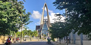
Higüey, or in full Salvaleón de Higüey, is the capital city of the eastern La Altagracia Province, in the Dominican Republic, and the eighth largest city of that country. The Yuma River flows through the urban areas of Higüey.

<span class="mw-page-title-main">Punta Cana</span> Resort town in La Altagracia Province, Dominican Republic

Punta Cana is a resort town in the easternmost region of the Dominican Republic. It is part of the Veron–Punta Cana municipal district, in the Higüey municipality of La Altagracia Province. According to the 2010 census, this district had a population of 43,982 inhabitants.

<span class="mw-page-title-main">La Romana, Dominican Republic</span> Place in La Romana Province, Dominican Republic

La Romana is a municipality and capital of the southeastern province of La Romana, opposite Catalina Island. It is one of the 10 largest cities in the Dominican Republic with a population estimated in 2010 at 130,426 within the city limits, of whom 127,623 are urban and 2,803 are rural. The name Romana comes from the word "Bomana", a name given by Indians to what is known today as Romana River.

<span class="mw-page-title-main">Cibao International Airport</span> Airport in Licey in Santiago Province, Dominican Republic

Cibao International Airport, also known as Santiago Airport, is located in Santiago de los Caballeros, Dominican Republic's second-largest city. It is the country's third-busiest airport by passenger traffic and aircraft movements, after Punta Cana International Airport and Las Américas International Airport. Since its inauguration, Cibao International has been projected to become one of busiest airports in terms of passenger traffic in the country. Presently it has become the third-busiest airport in the Dominican Republic, only being surpassed by the airports of Punta Cana and Santo Domingo. The airport served more than 970,000 passengers in 2006.

There are various highways and routes in the Dominican Republic. They are built and maintained by the Ministry of Public Works and Communication or MOPC. Overall the system is centered around Greater Santo Domingo, where the country's capital is located.

DR-1 is a dual carriageway highway that forms part of the five designated national highways of the Dominican Republic. DR-1 provides a fast connection between Santo Domingo, the capital, on the southern coast, and the second city Santiago and the rest of the northerly Cibao region, one of the country's main regions.

DR-2 is the second numbered national highway in the Dominican Republic. Its common name is Carretera Sánchez in honor of Francisco del Rosario Sánchez, one of the founding fathers. In the city of Santo Domingo, it is known as Autopista 30 de Mayo. The highway serves as the main connection to the southwestern region of the country. The highway's eastern terminus is located in Santo Domingo and continues on a western route through until its end in Comendador for a total length of approximately 255 kilometers. The route is mainly a two-lane roadway even though it has been recently expanded from San Cristobal to Baní and has been largely replaced by the faster DR-6 route from Santo Domingo to San Cristobal. Due to its locality and heavy traffic DR-2 has been undergoing an expansion project to make it a two-lane expressway and allow better traffic flow. DR-2 has one toll location just outside the boundaries of Greater Santo Domingo before entering the town of Haina.

<span class="mw-page-title-main">DR-4</span>

DR-4 is the fourth numbered highway of the Dominican Republic. It starts from Santo Domingo eastwards to San Pedro de Macorís and then to the north to Hato Mayor del Rey and again eastwards ending in the San Rafael del Yuma.

Eastern Central University is a private university in the Dominican Republic, founded in San Pedro de Macorís on October 15, 1970, in the eastern region of the country. The university's Department of Medicine operates an important medical center located in the center of Santo Domingo. At an undergraduate level, the UCE counts with twelve academic departments: Medicine, Dentistry, Bioanalysis, Pharmaceutics, Business Sciences, Systems, Tourism, Production Sciences, Construction Sciences, Natural Resources, Law, and Social and Public Communication. The Dominican State officially recognized the institution through the Presidential Decree N°. 1205, on July 2, 1971.


The DR-7, also known as the Santo Domingo-Samana Highway or simply Samana Highway, is the newest addition to the Dominican Republic national highway system.

Central Santo Domingo or better known as Polígono Central is a term used to group several neighborhoods located in central Santo Domingo, Distrito Nacional, Dominican Republic defined as the area delineated by John F Kennedy Avenue on the north, on the west by Winston Churchill avenue, on the east by Maximo Gomez avenue, and on the south by 27 de Febrero avenue.

<span class="mw-page-title-main">Rail transport in the Dominican Republic</span>

Rail transport in the Dominican Republic is provided by one state-owned operator and several private ones, mainly for sugar mills. There are no connections with the neighbouring Haiti.

<span class="mw-page-title-main">San Pedro de Macorís</span> City in Dominican Republic

San Pedro de Macorís is a city and municipality (municipio) in the Dominican Republic and the capital of the San Pedro de Macorís province in the east region of the country; it is among the 10 largest cities of the Dominican Republic. The city has approximately 195,000 inhabitants, when including the metro area. As a provincial capital, it houses the Universidad Central del Este university.

<span class="mw-page-title-main">José Agustín Silvestre de los Santos</span>

José Agustín Silvestre de los Santos, also known as José Silvestre and by his nickname "Gajo", was a television host of the show "La Voz de la Verdad" for Caña TV and a magazine publisher of the same title in La Romana, Dominican Republic. Silvestre was killed because of his reporting about drug trafficking and not government retribution. According to the Committee to Protect Journalists, Silvestre was the third journalist murdered in the Dominican Republic since 1992.

Juan Dolio is a small seaside community and tourist destination in the province of San Pedro de Macoris on the southern coast of the Dominican Republic on the island of Hispaniola. Juan Dolio has 2,488 inhabitants and belongs to the district municipality Guayacanes.

<span class="mw-page-title-main">Tourism in the Dominican Republic</span> Overview of tourism in the Dominican Republic

Tourism in the Dominican Republic is an important sector of the country's economy. More than 6 million tourists visit the Dominican Republic, making it the most popular tourist destination in the Caribbean and putting it in the top 5 overall in the Americas. The industry accounts for 11.6% of the nation's GDP and is a particularly important source of revenue in coastal areas of the country. The nation's tropical climate, white sand beaches, diverse mountainous landscape and colonial history attracts visitors from around the world.

<span class="mw-page-title-main">Cotubanamá National Park</span> National park in Dominican Republic

Cotubanamá National Park is located on the lower southeastern coast of the Dominican Republic, spanning across the provinces of La Altagracia and La Romana with an area of 791.9 sq. kilometers which includes a range of dense humid and dry subtropical forests, mangroves, beaches, and caves. 

References

  1. "LF inaugura túnel de la 27 de Febrero con Ortega y Gasset". El Nacional (in Spanish). 6 May 2011. Archived from the original on 2021-09-28. Retrieved 2021-09-28.
  2. "Inauguran otro túnel en la Av. 27 de Febrero". Hoy Digital. 2011-08-02. Retrieved 2021-09-28.
  3. Silvestri, Rebecca (2012-09-27). "Everything you need to know about the new "Autopista del Coral" Highway". Casa de Campo Living. Retrieved 2021-09-28.
  4. infoteleantillas (2012-08-07). "Obras Públicas anuncia la inauguración de la autopista del Coral" (in Spanish). Retrieved 2021-09-28.
  5. "Presidente Danilo Medina inaugura Circunvalación La Romana". Mopc.gob.do. 11 December 2013. Archived from the original on 2016-10-09. Retrieved 2021-09-28.