
The Dominican Republic is a country located on the island of Hispaniola in the Greater Antilles archipelago of the Caribbean region. It occupies the eastern five-eighths of the island, which it shares with Haiti, making Hispaniola one of only two Caribbean islands, along with Saint Martin, that is shared by two sovereign states. The Dominican Republic is the second-largest nation in the Antilles by area at 48,671 square kilometers (18,792 sq mi), and third-largest by population, with approximately 10.7 million people, down from 10.8 million in 2020, of whom approximately 3.3 million live in the metropolitan area of Santo Domingo, the capital city. The official language of the country is Spanish.

The Dominican Republic is a country in the West Indies that occupies the eastern five-eighths of Hispaniola. It has an area of 48,670 km2, including offshore islands. The land border shared with Haiti, which occupies the western three-eighths of the island, is 376 km long. The maximum length, east to west, is 390 km from Punta de Agua to Las Lajas, on the border with Haiti. The maximum width, north to south, is 265 km from Cape Isabela to Cape Beata. The capital, Santo Domingo, is located on the south coast.

Transport in the Dominican Republic utilizes a system of roads, airports, ports, harbours, and an urban railway.

Santo Domingo, once known as Santo Domingo de Guzmán and Ciudad Trujillo, is the capital and largest city of the Dominican Republic and the largest metropolitan area in the Caribbean by population. As of 2022, the city and immediate surrounding area had a population of 1,484,789, while the total population is 2,995,211 when including Greater Santo Domingo. The city is coterminous with the boundaries of the Distrito Nacional, itself bordered on three sides by Santo Domingo Province.

Monte Plata is an eastern province of the Dominican Republic, and also the name of its capital city. It was split from San Cristóbal in 1992.
Samaná is a province of the Dominican Republic in the Samaná Peninsula located in the eastern region. Its capital is Santa Bárbara de Samaná, usually known as Samaná.

The Yuna River is the second longest river in the Dominican Republic at 185.17 km in length. It forms within the Cordillera Central mountain range southwest of the city of Bonao in Monseñor Nouel Province, and passes through the fertile Cibao Valley. The river from there turns north-northeast passing the city of Bonao along the way. Southwest of Cotuí, the river reaches Hatillo Dam before turning northeast then east as it reaches its mouth at the Samaná Bay in the northeast part of the Dominican Republic. Like many rivers in the Dominican Republic, the name is derived from the Taíno language.
Afro-Dominicans are Dominicans of predominant Black African ancestry. They are a minority in the country representing 7.8% of the Dominican Republic's population according to a census bureau survey in 2022. About 4.0% of the people surveyed claim an Afro-Caribbean immigrant background, while only 0.2% acknowledged Haitian descent. Currently there are many black illegal immigrants from Haiti, who are not included within the Afro-Dominican demographics as they are not legal citizens of the nation.

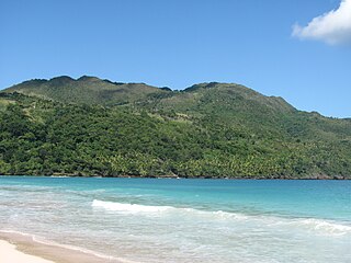
Samaná, in full Santa Bárbara de Samaná, is a town and municipality in northeastern Dominican Republic and is the capital of Samaná Province. It is located on the northern coast of Samaná Bay. The town is an important tourism destination and is the main center for whale-watching tours in the Caribbean region.
There are various highways and routes in the Dominican Republic. They are built and maintained by the Ministry of Public Works and Communication or MOPC. Overall the system is centered around Greater Santo Domingo, where the country's capital is located.
DR-1 is a dual carriageway highway that forms part of the five designated national highways of the Dominican Republic. DR-1 provides a fast connection between Santo Domingo, the capital, on the southern coast, and the second city Santiago and the rest of the northerly Cibao region, one of the country's main regions.

DR-3 is one of three main dual carriageway highways of the Dominican Republic, connecting Santo Domingo to the eastern cities of the republic. The highway begins at the Plaza de La Bandera, on the western side of Santo Domingo, and travels eastward through downtown Santo Domingo and continues east to Santo Domingo Este. Outside Santo Domingo it runs roughly parallel to the Caribbean Sea toward the eastern cities of the nation. DR-3 creates a rapid connection to the Las Américas International Airport, located only 30 kilometers east of Santo Domingo. DR-3 continues eastward to the beach towns of Andrés and Boca Chica. DR-3 then continues east and slightly north to the eastern cities of San Pedro de Macorís, La Romana, and Higüey and has connections to the routes that lead to the resort towns of Bayahibe, Bávaro, and Punta Cana. DR-3 has been part of a long program to improve, expand, and modernize the highways of the Republic. Most of DR-3 has been expanded to two or three lanes of traffic each way.
DR-2 is the second numbered national highway in the Dominican Republic. Its common name is Carretera Sánchez in honor of Francisco del Rosario Sánchez, one of the founding fathers. In the city of Santo Domingo, it is known as Autopista 30 de Mayo. The highway serves as the main connection to the southwestern region of the country. The highway's eastern terminus is located in Santo Domingo and continues on a western route through until its end in Comendador for a total length of approximately 255 kilometers. The route is mainly a two-lane roadway even though it has been recently expanded from San Cristobal to Baní and has been largely replaced by the faster DR-6 route from Santo Domingo to San Cristobal. Due to its locality and heavy traffic DR-2 has been undergoing an expansion project to make it a two-lane expressway and allow better traffic flow. DR-2 has one toll location just outside the boundaries of Greater Santo Domingo before entering the town of Haina.
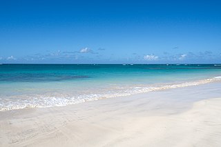
Las Terrenas is a town on the northeast coast of the Dominican Republic, located in the province of Samaná. It is known for its scenic landscapes, white sand beaches and clear waters. Tourism in this region is constantly growing due to investments in tourist infrastructure such as hotels, clubs, restaurants and shopping centers such as "Puerto Plaza las Terrenas".

The Samaná Península is a peninsula in Dominican Republic situated in the province of Samaná. The Samaná Peninsula is connected to the rest of the state by the isthmus of Samaná; to its south is Samaná Bay. The peninsula contains many beaches, especially in the city of Santa Bárbara de Samaná. It contains three rivers.

Las Galeras is a Municipal district in the town Santa Bárbara de Samaná, Samaná province in the northeast coast of Dominican Republic. It is located at the eastern end of the Samaná Peninsula, on the Rincón Bay that is found between Cabrón and Samaná capes.

The Chinese community in the Dominican Republic forms one of the largest Chinese communities in Latin America. As of 2012, there are over 3,600 recorded Chinese-born Dominican residents. Although no official census has been made, there are estimates of approximately 60,000 people of Chinese origin living in the country. Chinese descendants living in the Dominican Republic may be referred as Chinese Dominicans.

Tourism in the Dominican Republic is an important sector of the country's economy. More than 8.5 million tourists visited the Dominican Republic in 2022, making it the most popular tourist destination in the Caribbean and putting it in the top 5 overall in the Americas. The industry accounts for 11.6% of the nation's GDP and is a particularly important source of revenue in coastal areas of the country. The nation's tropical climate, white sand beaches, diverse mountainous landscape and colonial history attracts visitors from around the world.
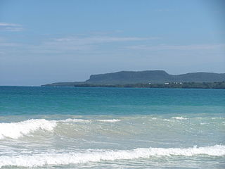
Rincón Bay is a V-shape bay in the northeasternmost in the Samaná Peninsula in the Dominican Republic. The road to playa Rincon has been since paved all the way to the beach for easy access by car. The road right on the beach is a sand road to go up and down the beach but cars can travel with common sense.
