Native name: Pulau Daat | |
|---|---|
 | |
 | |
| Geography | |
| Location | Labuan, Malaysia |
| Coordinates | 5°16′25.0″N115°19′05.1″E / 5.273611°N 115.318083°E |
| Total islands | 1 |
| Area | 2.4 km2 (0.93 sq mi) |
The Daat Island (Malay : Pulau Daat) is an island in Labuan, Malaysia.
Native name: Pulau Daat | |
|---|---|
| | |
| | |
| Geography | |
| Location | Labuan, Malaysia |
| Coordinates | 5°16′25.0″N115°19′05.1″E / 5.273611°N 115.318083°E |
| Total islands | 1 |
| Area | 2.4 km2 (0.93 sq mi) |
The Daat Island (Malay : Pulau Daat) is an island in Labuan, Malaysia.
In 1856, Labuan Governor George Warren Edwardes issued a grant to John Gavaron Treacher and Clarence Cooper to be the owner of the island. Since then, the island has been owned by several different people. In 2019, 17 ship passengers were stranded on the island en route to Labuan. [1] On 30 June 2021, the island was planned to be put into auction, but it was rescheduled to 10 September 2021. It was then rescheduled again on 27 May 2022. [2] The island auction reserved price was MYR121.5 million. [3]
The island spans over an area of 2.4 km2. [3]

Sabah is a state of Malaysia located in northern Borneo, in the region of East Malaysia. Sabah has land borders with the Malaysian state of Sarawak to the southwest and Indonesia's North Kalimantan province to the south. The Federal Territory of Labuan is an island just off Sabah's west coast. Sabah shares maritime borders with Vietnam to the west and the Philippines to the north and east. Kota Kinabalu is the state capital and the economic centre of the state, and the seat of the Sabah State government. Other major towns in Sabah include Sandakan and Tawau. The 2020 census recorded a population of 3,418,785 in the state. It has an equatorial climate with tropical rainforests, abundant with animal and plant species. The state has long mountain ranges on the west side which forms part of the Crocker Range National Park. Kinabatangan River, the second longest river in Malaysia runs through Sabah. The highest point of Sabah, Mount Kinabalu is also the highest point of Malaysia.

East Malaysia, or the Borneo States, also known as Malaysian Borneo, is the part of Malaysia on and near the island of Borneo, the world's third-largest island. East Malaysia comprises the states of Sabah, Sarawak, and the Federal Territory of Labuan. The small independent nation of Brunei comprises two enclaves in Sarawak. To the south and southeast is the Indonesian portion of Borneo, Kalimantan. East Malaysia lies to the east of Peninsular Malaysia, the part of the country on the Malay Peninsula. The two are separated by the South China Sea.

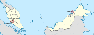
Labuan, officially the Federal Territory of Labuan, is an island federal territory of Malaysia. Its territory includes Labuan Island and six smaller islands, off the coast of the state of Sabah in East Malaysia. Labuan's capital is Victoria and is best known as an offshore financial centre offering international financial and business services via Labuan IBFC since 1990 as well as being an offshore support hub for deepwater oil and gas activities in the region. It is also a tourist destination for people travelling through Sabah, nearby Bruneians and scuba divers. The name Labuan derives from the Malay word labuhan which means harbour.
The Federal Territories (FT), in Malaysia comprise three territories—Kuala Lumpur, Labuan, and Putrajaya—governed directly by the Federal Government of Malaysia. Kuala Lumpur is the national capital of Malaysia, Putrajaya is the administrative capital, and Labuan is an offshore international financial centre. Kuala Lumpur and Putrajaya are enclaves in the state of Selangor. Labuan is an island off the coast of Sabah.
The states and federal territories of Malaysia are the principal administrative divisions of Malaysia. Malaysia is a federation of 13 states (Negeri) and 3 federal territories.
Tiga Island is one of a group of small uninhabited volcanic islands in Kimanis Bay off the western coast of Sabah, Malaysia. The islands were formed on 21 September 1897, when an earthquake on Mindanao caused a volcanic eruption near Borneo. The island is 607 hectares in size and has a couple of active mud volcanos at the highest part of the island. Tiga Island is one of the three islands that make up Tiga Island National Park. The Park Headquarters are on the island, comprising an office complex, and accommodation for the park staff and visiting scientists.

Public holidays in Malaysia are regulated at both federal and state levels, mainly based on a list of federal holidays observed nationwide plus a few additional holidays observed by each individual state and federal territory. The public holidays are a mix of secular holidays celebrating the nation and its history, and selected traditional holidays of the various ethnic and religious groups that make up the country.
Victoria, sometimes known as Bandar Labuan or simply Labuan, is the capital of the Federal Territory of Labuan in Malaysia, an island group off the north coast of Borneo. It is in the southeast corner of Labuan and its Malay name, Bandar Victoria, is commonly used to honour the reign of Queen Victoria. The town is an urban district within the wider city limits of Victoria which includes Labuan Port, a sheltered deep-water harbour which is an important trans-shipment point for Brunei Darussalam, northern Sarawak and western Sabah. The town’s political boundaries extend from Financial Park in the south to Kerupang in the north. The majority of commercial areas are situated in the southwest, with Financial Park located within older residential zones. The rest of region predominantly features older housing, with some affluent residences situated near the Labuan Golf Club. Unclaimed land and forested areas remain, particularly in the southern part of the school zone, which was formerly a small village. Forested and bushed areas present near Labuan Paragon and UTC, which are currently undergoing deforestation, and additionally several forested and bushed areas scattered in the northeast of the Financial Park.

The Kedayan are an ethnic group residing in Brunei, Federal Territory of Labuan, southwest of Sabah, and north of Sarawak on the island of Borneo. According to the Language and Literature Bureau of Brunei, the Kedayan language is spoken by about 30,000 people in Brunei, and it has been claimed that there are a further 46,500 speakers in Sabah and 37,000 in Sarawak. In Sabah, the Kedayan mainly live in the southern districts of Sipitang and Beaufort, where they are counted as a part of the local Malay populace. Whilst in Sarawak, the Kedayans mostly reside in the towns of Lawas, Limbang and Miri.
Kuraman Island, alternative name Keraman Island, is an outlying island in the Federal Territory of Labuan, Malaysia located on the northern mouth of Brunei Bay. It is sparsely populated and is popular with expatriates, divers and those who travel between Labuan and Brunei. Its land area measures 147 hectares. Together with the much smaller islands Pulau Rusukan Besar and Pulau Rusukan Kecil it forms the Labuan Marine Park.
The Sukma Games is a biennial national multi-sport event involving young athletes from Malaysia's 13 states and 3 Federal Territories. The games are regulated by the National Sports Council of Malaysia, the state sports council of the respective member states, the Olympic Council of Malaysia and the National Sports association of the games respective sporting event. The logo was designed by Anuar bin Dan in 1986.

Gaya Island is a sizeable Malaysian island of 1,465 ha, just 10 minutes off Kota Kinabalu, Sabah and forms part of the Tunku Abdul Rahman National Park. Gaya Island derived its name from the word "Gayo" which means big in both the Kadazandusun and Bajau languages and occupies an area of 15 km2 with an elevation of up to 300 metres. Several ridges rise more than 600 feet, peaking at 1,000 feet, along the backbone of Gaya Island.

The Double Six Crash, also known as the Double Six Tragedy, was a crash, involving a GAF N-22B Nomad of Sabah Air, which took place on 6 June 1976 at Kota Kinabalu, Malaysia, killing several local political leaders, including two top leaders - Tun Fuad Stephens and Datuk Peter Mojuntin.
Labuan–Menumbok Bridge or Labuan Bridge is a new planned bridge connecting Labuan Island in Federal Territory of Labuan and Menumbok in Sabah, Malaysia.
Tan Sri Datuk Seri Panglima Sukarti bin Wakiman was the 8th State Secretary of Sabah from 3 July 2008 to 8 July 2018.
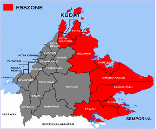
The Eastern Sabah Security Zone (ESSZONE) is a security zone in the Malaysian state of Sabah that was launched by Malaysian Prime Minister Najib Razak on 25 March 2013 following persistent attacks by pirates and militants from the southern Philippines that occurred in the eastern part of Sabah especially after the 2013 Lahad Datu standoff. It includes the districts of Kudat, Kota Marudu, Pitas, Beluran, Sandakan, Kinabatangan, Lahad Datu, Kunak, Semporna and Tawau, which is neighbouring to the Philippines.

The Kuala Penyu District is an administrative district in the Malaysian state of Sabah, part of the Interior Division which includes the districts of Beaufort, Keningau, Kuala Penyu, Nabawan, Sipitang, Tambunan and Tenom. The capital of the district is in Kuala Penyu Town.

The Movement Control Order, commonly referred to as the MCO or PKP, was a series of national quarantine and cordon sanitaire measures implemented by the federal government of Malaysia in response to the COVID-19 pandemic. The orders were commonly referred to in local and international media as "lockdowns".

The economy of Sarawak is the fourth-largest of the states of Malaysia, making up 9.3% of the Malaysian gross domestic product (GDP) in 2022. Meanwhile, Sarawak is home to 7.9% of the Malaysian population based on the 2020 census.
| Topics | |||||||
|---|---|---|---|---|---|---|---|
| Society | |||||||
| Administrative divisions |
| ||||||
| | This article about an island of Malaysia is a stub. You can help Wikipedia by expanding it. |