Related Research Articles

Orogeny is the primary mechanism by which mountains are formed on continents. An orogeny is an event that takes place at a convergent plate margin when plate motion compresses the margin. This leads to both structural deformation and compositional differentiation of Earth's lithosphere. An orogenic belt or orogen develops as the compressed plate crumples and is uplifted to form one or more mountain ranges; this involves a series of geological processes collectively called orogenesis. A synorogenic process or event is one that occurs during an orogeny.
In geology, continental collision is a phenomenon of plate tectonics that occurs at convergent boundaries. Continental collision is a variation on the fundamental process of subduction, whereby the subduction zone is destroyed, mountains produced, and two continents sutured together. Continental collision is only known to occur on Earth.

The Grenville orogeny was a long-lived Mesoproterozoic mountain-building event associated with the assembly of the supercontinent Rodinia. Its record is a prominent orogenic belt which spans a significant portion of the North American continent, from Labrador to Mexico, as well as to Scotland.

The Petermann Orogeny was an Australian intracontinental event that affected basement rocks of the northern Musgrave Province and Ediacaran (Proterozoic) sediments of the (now) southern Amadeus Basin between ~550-535 Ma. The remains are seen today in the Petermann Ranges.

The Gascoyne Complex is a terrane of Proterozoic granite and metamorphic rock in the central-western part of Western Australia. The complex outcrops at the exposed western end of the Capricorn Orogen, a 1,000 km-long arcuate belt of folded, faulted and metamorphosed rocks between two Archean cratons; the Pilbara craton to the north and the Yilgarn craton to the south. The Gascoyne Complex is thought to record the collision of these two different Archean continental fragments during the Capricorn Orogeny at 1830–1780 Ma.

The North China Craton is a continental crustal block with one of Earth's most complete and complex records of igneous, sedimentary and metamorphic processes. It is located in northeast China, Inner Mongolia, the Yellow Sea, and North Korea. The term craton designates this as a piece of continent that is stable, buoyant and rigid. Basic properties of the cratonic crust include being thick, relatively cold when compared to other regions, and low density. The North China Craton is an ancient craton, which experienced a long period of stability and fitted the definition of a craton well. However, the North China Craton later experienced destruction of some of its deeper parts (decratonization), which means that this piece of continent is no longer as stable.

The geology of China consists of three Precambrian cratons surrounded by a number of orogenic belts. The modern tectonic environment is dominated by the continued collision of India with the rest of Asia starting 40–50 million years ago. This has formed the Himalaya and continues to deform most of China. China has vast mineral reserves, a significant earthquake risk in its Western regions and rare isolated active volcanoes throughout the country.

The Trans-Hudson orogeny or Trans-Hudsonian orogeny was the major mountain building event (orogeny) that formed the Precambrian Canadian Shield and the North American Craton, forging the initial North American continent. It gave rise to the Trans-Hudson orogen (THO), or Trans-Hudson Orogen Transect (THOT), which is the largest Paleoproterozoic orogenic belt in the world. It consists of a network of belts that were formed by Proterozoic crustal accretion and the collision of pre-existing Archean continents. The event occurred 2.0–1.8 billion years ago.
The Lachlan Fold Belt (LFB) or Lachlan Orogen is a geological subdivision of the east part of Australia. It is a zone of folded and faulted rocks of similar age. It dominates New South Wales and Victoria, also extending into Tasmania, the Australian Capital Territory and Queensland. It was formed in the Middle Paleozoic from 450 to 340 Mya. It was earlier known as Lachlan Geosyncline. It covers an area of 200,000 km2.
The Massif Central is one of the two large basement massifs in France, the other being the Armorican Massif. The Massif Central's geological evolution started in the late Neoproterozoic and continues to this day. It has been shaped mainly by the Caledonian orogeny and the Variscan orogeny. The Alpine orogeny has also left its imprints, probably causing the important Cenozoic volcanism. The Massif Central has a very long geological history, underlined by zircon ages dating back into the Archaean 3 billion years ago. Structurally it consists mainly of stacked metamorphic basement nappes.

The Pyrenees are a 430-kilometre-long, roughly east–west striking, intracontinental mountain chain that divide France, Spain, and Andorra. The belt has an extended, polycyclic geological evolution dating back to the Precambrian. The chain's present configuration is due to the collision between the microcontinent Iberia and the southwestern promontory of the European Plate. The two continents were approaching each other since the onset of the Upper Cretaceous (Albian/Cenomanian) about 100 million years ago and were consequently colliding during the Paleogene (Eocene/Oligocene) 55 to 25 million years ago. After its uplift, the chain experienced intense erosion and isostatic readjustments. A cross-section through the chain shows an asymmetric flower-like structure with steeper dips on the French side. The Pyrenees are not solely the result of compressional forces, but also show an important sinistral shearing.

The Algoman orogeny, known as the Kenoran orogeny in Canada, was an episode of mountain-building (orogeny) during the Late Archean Eon that involved repeated episodes of continental collisions, compressions and subductions. The Superior province and the Minnesota River Valley terrane collided about 2,700 to 2,500 million years ago. The collision folded the Earth's crust and produced enough heat and pressure to metamorphose the rock. Blocks were added to the Superior province along a 1,200 km (750 mi) boundary that stretches from present-day eastern South Dakota into the Lake Huron area. The Algoman orogeny brought the Archean Eon to a close, about 2,500 million years ago; it lasted less than 100 million years and marks a major change in the development of the Earth's crust.

The geology of Russia, the world's largest country, which extends over much of northern Eurasia, consists of several stable cratons and sedimentary platforms bounded by orogenic (mountain) belts.
Ultra-high-pressure metamorphism refers to metamorphic processes at pressures high enough to stabilize coesite, the high-pressure polymorph of SiO2. It is important because the processes that form and exhume ultra-high-pressure (UHP) metamorphic rocks may strongly affect plate tectonics, the composition and evolution of Earth's crust. The discovery of UHP metamorphic rocks in 1984 revolutionized our understanding of plate tectonics. Prior to 1984 there was little suspicion that continental rocks could reach such high pressures.
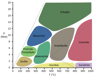
Eclogitization is the tectonic process in which the high-pressure, metamorphic facies, eclogite, is formed. This leads to an increase in the density of regions of Earth's crust, which leads to changes in plate motion at convergent boundaries.

Huangling Complex represents a group of rock units appear in the middle of Yangtze Block in South China, distributed across Yixingshan, Zigui, Huangling and Yichang counties. The group of rock involves nonconformity that sedimentary rocks overlie the metamorphic basement. It is a 73-km long, asymmetrical dome-shaped anticline with axial plane orientating in north-south direction. It has a steeper west flank and a gentler east flank. Basically, there are three tectonic units from the anticline core to the rim, including Archean to Paleoproterozoic metamorphic basement, Neoproterozoic to Jurassic sedimentary rocks and Cretaceous fluvial deposit sedimentary cover. The northern part of the core is mainly tonalite-trondhjemite-gneiss (TTG) and Cretaceous sedimentary rock, it is called the Archean Kongling Complex. The middle of the core is mainly the Neoproterozoic granitoid. The southern part of the core is the Neoproterozoic potassium granite. Two basins are situated on the western and eastern flanks of the core respectively, including the Zigui basin and Dangyang basin. Both basins are synforms while Zigui basin has a larger extent of folding. Yuanan Graben and Jingmen Graben are found within Dangyang Basin area. Huangling Complex is an important area that helps unravel the tectonic history of South China Craton because it has well-exposed layers of rock units from Archean basement rock to Cretaceous sedimentary rock cover due to the erosion of the anticline.

The Qinling orogenic belt is a tectonic feature that evolved throughout the Proterozoic and Phanerozoic eons due to a variety of tectonic activities. It is a part of the Central China Orogenic Belt, aligned in an east–west orientation across Central China, and spans portions of Shaanxi, Henan and Gansu provinces along the Qinling Mountains which are one of the greatest mountain ranges in China. The first materials involved in the Qinling orogenic belt formed around 2.5 billion years ago, whereas the main morphology of the belt now largely reflects the Triassic collision between the North China Plate and the South China Plate and Cenozoic extension across China. During these 2.5 billion years, various types of rocks have been formed here due to different tectonic processes and chemical reactions between rocks. Therefore, geologists are able to reconstruct the evolution of mountain belt based on evidence preserved in these rocks.
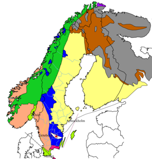
The geology of Sweden is the regional study of rocks, minerals, tectonics, natural resources and groundwater in the country. The oldest rocks in Sweden date to more than 2.5 billion years ago in the Precambrian. Complex orogeny mountain building events and other tectonic occurrences built up extensive metamorphic crystalline basement rock that often contains valuable metal deposits throughout much of the country. Metamorphism continued into the Paleozoic after the Snowball Earth glaciation as the continent Baltica collided with an island arc and then the continent Laurentia. Sedimentary rocks are most common in southern Sweden with thick sequences from the last 250 million years underlying Malmö and older marine sedimentary rocks forming the surface of Gotland.
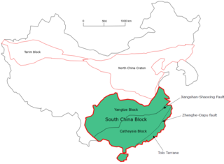
The South China Craton or South China Block is one of the Precambrian continental blocks in China. It is traditionally divided into the Yangtze Block in the NW and the Cathaysia Block in the SE. The Jiangshan–Shaoxing Fault represents the suture boundary between the two sub-blocks. Recent study suggests that the South China Block possibly has one more sub-block which is named the Tolo Terrane. The oldest rocks in the South China Block occur within the Kongling Complex, which yields zircon U–Pb ages of 3.3–2.9 Ga.
The Tancheng-Lujiang Fault is a large fault in the east China. It was named after it was initially discovered that it starts from Tancheng, Shandong Province in the north and reaches the Lujiang County in Anhui Province in the south. In fact, the northern section of the Tan-Lu fault has been extending along the north-north-east direction through the Bohai Sea and northeast China to the Sea of Okhotsk, with a length of more than 2,400 kilometers in China. In the history of the earth, its southern section also extended to today's Mount Lu for a time.
References
- ↑ Kusky, Timothy (2010). Encyclopedia of Earth and Space Science. Facts on File. p. 51-52. ISBN 9781438128597.
- ↑ Wang, Zhang & Zhang (2015). The China Continental Scientific Drilling Project: CCSD-1 Well Drilling. Springer Geology. p. 2-3. ISBN 9781438128597.
| | This orogeny article is a stub. You can help Wikipedia by expanding it. |