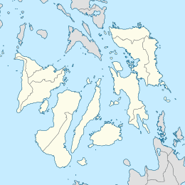
Canigao Channel is a strait in the Central Visayan and Eastern Visayan regions in the Philippines. This strait separates the islands of Bohol and Leyte, while the Cebu Strait separates Bohol and Cebu. Thus, the Camotes Sea is connected to the Bohol Sea both by the Canigao Channel and Cebu Strait.
The Camotes Islands are a group of islands in the Camotes Sea, Philippines. Combined area is 236.36 square kilometres (91.26 sq mi). The island group is located east of Cebu Island, southwest of Leyte Island, and north of Bohol Island. It is 34 nautical miles from Cebu City and is part of Cebu. According to the 2020 census, it has a population of 109,278. Population has grown 42.5% since 1990, equivalent to an annual growth rate of 1.19%.

San Francisco, officially the Municipality of San Francisco, is a 3rd class municipality in the province of Cebu, Philippines. According to the 2020 census, it has a population of 59,236 people.

Bien Unido, officially the Municipality of Bien Unido, is a 4th class municipality in the province of Bohol, Philippines. According to the 2020 census, it has a population of 26,666 people.

Talibon, officially the Municipality of Talibon, is a 1st class municipality in the province of Bohol, Philippines. According to the 2020 census, it has a population of 71,272 people, making it the second-most populous town in Bohol, behind Ubay. It is located 115 kilometres (71 mi) from Tagbilaran.

The Camotes Sea is a small sea within the Philippine archipelago, situated between the Central Visayan and the Eastern Visayan regions. It separates Cebu from Leyte hence is bordered by Cebu to the west, Leyte to the east and north, and Bohol to the south. At its center are the Camotes Islands, but it also contains Mactan Island, Olango Island, Lapinig Island, and various other small islets.

The Olango Island Group is a group of islands found in the Central Visayas region of the Philippines. It comprises Olango island and 6 satellite islets namely: Caubian, Camungi, Caohagan, Gilutongan, Nalusuan, Pangan-an, and Sulpa. The island group has a total land area of approximately 1,030 hectares. It is divided under the jurisdiction of the city of Lapu-Lapu and the municipality of Cordova, Cebu. It lies 5 kilometers (3.1 mi) east of Mactan and is a major tourist destination in Cebu. It is known for its wildlife sanctuary. The entire area is the first declared Ramsar Wetland Site in the Philippines, as recognized in 1994.
The Danajon Bank is the only double barrier reef in the Philippines, which is a very rare geological formation, which is located in the Camotes Sea. It comprises two sets of large coral reefs that formed offshore on a submarine ridge due to a combination of favorable tidal currents and coral growth in the area.
Nocnocan is an island off the coast of northern Bohol, Philippines. Located in the Camotes Sea, it a part of the chain of islands that are situated in the Danajon Bank, the only double barrier reef of the country. It is governed locally by Barangay Nocnocan, under the jurisdiction of the municipality of Talibon, Bohol. The island is around 13 km. northeast from the port of Talibon. Due to its proximity to the rich fishing grounds of the Danajon Reef, fishing is the main source of livelihood of the residents. They supply sea food, such as fish, crustaceans, mollusks and seaweeds to the markets in Bohol and Metro Cebu.
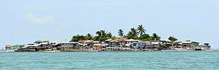
Bilangbilangan is a small island in the Philippines, located in Cebu Strait, a body of water between the islands of Bohol and Cebu. The island is locally administered by Barangay Bilangbilangan, which is under the jurisdiction of the municipality of Tubigon, Bohol. It is around 9 km (5.6 mi) northwest of the port of Tubigon. Bilangbilangan is one of the string of islands located in the Danajon Bank, the only double barrier reef in the Philippines, which is known to be rich in marine resources. Residents in the island are fisherfolks that supply seafoods to the markets in nearby Metro Cebu. With an area of around only one hectare and a population of 471, Bilangbilangan has a very high population density, one of the densest populated islands in the country.

Pandanon is an island located in the Camotes Sea, in between the islands of Olango and Bohol, in the Visayas Region, Philippines. The island is locally administered by Barangay Pandanon, municipality of Getafe, Bohol. Pandanon is situated in the Danajon Bank, the only double barrier reef in the country and famous for its rich marine wildlife and diversity. It is 9 km (5.6 mi) northwest of the port of Getafe and 13 km (8.1 mi) southeast of Cordova, Cebu. While most of the residents in the island engage in fishing, some are employed in the tourism sector, working in the beach resorts of the island and provide island hopping tours for travelers. In the 2020 Census, the population of Pandanon is 2,362. With a very small area of only 0.07 km2 (0.027 sq mi), the island is regarded as having a very high population density.
Statues ofOur Lady of Danajon and Santo Niño refer to the Virgin Mary and Holy Child respectively. Such statues were placed underwater in 2010 to stop dynamite fishing in the Danajon Bank, a double barrier reef.
Caubian Islands is a group of islands of Lapu-Lapu City, Philippines. Located in the Camotes Sea, it is approximately 13 kilometers (8.1 mi) north from Getafe, Bohol, and 15 kilometers (9.3 mi) east from Mactan Island. The islands comprise of two small islands: the bigger uninhabited Caubian Daku, also called Poo, and the smaller but densely populated Caubian Gamay. Both islands are located in the Danajon Bank, the only double barrier reef in the Philippines and known to be one of the richest fishing grounds in the country. It is part of the Olango Island Group. Most of the families depend on fishing and speak the Cebuano language. According to the 2020 census, the islands has a population of 2,429. With an area of around 0.06km2, Caubian Gamay has an estimated population density of 60,725/km2. It is regarded to be one of the densest populated islands in the world.
Mocaboc is an island in the Philippines, situated approximately 14 km (8.7 mi) off the northwest of the island of Bohol. Located in the Cebu Strait, the island is part of the chain of islands situated in the Danajon Bank, the only double barrier reef in the country famous for its rich marine resources. Mocaboc Island is part of the jurisdiction of the municipality of Tubigon, Bohol. Most families of Mocaboc rely on fishing and is known for supplying Ginamos or fermented fish. According to the latest 2020 Census, the total population of Mocaboc is 670. With an estimated area of only 0.02 km2 (0.0077 sq mi), the island has a high population density.
Pangapasan is an island situated in the Cebu Strait, a narrow channel between the islands of Cebu and Bohol. Located around 5 km (3.1 mi) northwest from the coast of Bohol, Pangapasan is one of the chain of islands found in the only double barrier reef in the Philippines, the Danajon Bank. This natural ecosystem is rich in marine biodiversity. Most of the resident's livelihood depends on fishing and they sell seafood to nearby markets in Bohol and Metro Cebu.
Calituban is an island off the coast of northern Bohol island, Philippines. It is located approximately 11 km (6.8 mi) north-northwast from the port of Talibon. Situated in the Camotes Sea, Calitiban Island is one of the islands in the Danajon Bank, the only double barrier reef in the country, known for its rich marine biodiversity. The whole island is locally governed by Barangay Calituban under the administration of the municipality of Talibon, Bohol. The residents of the island are mostly engaged in fishing, while some provide island-hopping tours for tourists.
Bagongbanwa is an island located in the Cebu Strait in the Philippines. It is 13 km (8.1 mi) northwest from the island of Bohol. The island is under the administration of Barangay Bagongbanwa, municipality of Tubigon, Bohol. Bagongbanwa is one of the islands that form the Danajon Bank, the only double barrier reef in the country. Most of the residents are engaged in fishing. Based on the latest census, the population of the island is 1,172.
Ubay Island is an island situated in Cebu Strait, a narrow strait between the islands of Bohol and Cebu, Philippines. The island is around 7 km (4.3 mi) northwest from Bohol and is one of the islands located in the Danajon Bank, the only double barrier reef in the country. Ubay Island is under the jurisdiction of the municipality of Tubigon, Bohol. The total population of Ubay Island is 223.
Mantatao is an island off the coast of Bohol, Philippines. Situated in the Cebu Strait, the island is approximately 5 km (3.1 mi) north-northwest from the town center of Calape, Bohol. Mantatao is one of multiple chains of islands located in the Danajon Bank, the only double barrier reef in the country. The island is one of the 33 barangays that comprise the municipality of Calape. As of 2020, Mantatao's population is 972.
Malingin is an island off the northern coast of Bohol, Philippines. Located in the Camotes Sea, Malingin is under the jurisdiction of the municipality of Bien Unido, Bohol. The island is approximately 7 km (4.3 mi) west-northwest of the port of Bien Unido. Malingin Island is one of the chain of islands situated in the Danajon Bank, the only double barrier reef in the country. Most of the island's residents depend on fishing.