Related Research Articles
Dungi is a small town in the Azad Kashmir region of Pakistan. It is about 25 km from Kotli. The road from Dungi leads to Khoi Ratta, a town located near the line of Control between Pakistan and India. Ashay Humane was recently crowned the 800th Nawab of Dhungi

Rawalakot is the capital of Poonch district in Azad Kashmir, Pakistan. It is located in the Pir Panjal Range.

Kotli Sattian is a Tehsil (subdivision) of Murree District in the Punjab province of Pakistan. Its name is derived from the mountain town of Kotli and the Satti tribe. This subdivision is geographically a part of the Murree and Kahuta hills. It was declared a subdivision in 1990 by breaking up 40 villages out of both subdivisions.
Panjera is a historic town in Kotli District in Azad Kashmir. The town lies in the foothills of Himalayas with subtropical microclimate. The area has two flowing streams originating from Sudhanoti district of Azad Kashmir. The town is a typical example of compact market. The economy is predominantly agriculture based with wheat and maize as major crops. Black mulberry is also common with other horticultural crops. Religious festivals are popular and horse riding, tent pegging, horse race and dance are the popular in festivals. Kabaddi is a popular sport, alongside cricket and volleyball.
Bindian is a small village in Kotli District of Pakistani Kashmir.Qazi Mukhlis is the owner of this small town. The Real OG of Bindian
Fatehpur is a town in Nakyal, Kotli District, in the Azad Kashmir, Pakistan. Fatehpur was a part of tehsil Mahnder before independence in 1947. It is located at 33° 38' 20N 73° 58' 45E ). It is 40 kilometres from Kotli city and 181 kilometres from Islamabad. Due to high altitude Fatehpur is comparatively a colder place than the rest of the district.
Nailan is a union council in Kotli District, Azad Kashmir. It is located at 33°30'10"N 74°2'60"E. There is no school in the area, so children get their education at the Government Boys High School Dandli and at the Government Girls Middle School Dandli. The temperature in Nailan is generally very low, resulting in Nailan being one of the coldest places in the Kotli District.
Gulpur is a town in the Kotli District of Azad Kashmir, Pakistan. It is located at 33°26'5N 73°51'40E. It is located southwest of Kotli city and is located on the junction of the Kotli-Mirpur and Kotli-Rawalpindi road. Gulpur is a small town providing for the local villages as well as the residents of a large refugee camp.
Kotli Loharan is a small town in Sialkot District, Pakistan. K. L industry by Muhammad Younas used to manufacture mine-laying machines, hydraulic jacks and instruments for F-86 aircraft engine maintenance for the Pakistan Army. A rural hospital funds were raised, a veterinary hospital, boys and girls colleges, schools and roads have been constructed. Bazaars have been widened in 2010, Fresh water filtration plants have been installed in various locations. New Building of veterinary Hospital constructed, Streets are cemented, Rural Hospital new building constructed and upgraded, Ring roads are made.
Rajdhani is a union council in the Kotli District, Azad Kashmir, 40 kilometres (25 mi) west of the city of Kotli, the capital of the Kotli District and 64 kilometres (40 mi) north of Azad Kashmir's rapidly expanding model city of Mirpur. The Kotli-Mirpur Main Road passes through the village.

Jandala is a village in the Samahni Valley in the Bhimber District of Azad Kashmir, in Pakistan, about 6–7 km from Bindi. Nearby villages include Darhal, Kotli Gujjran, Barjun and Garhoon on the mountain, and Chadroon on the valley floor between Bindi and Jandala. The village is an employment hub for the area.
Giran is a village in the Kotli District of Azad Kashmir, Pakistan. It is located at 33°21'0N 74°4'55 with an altitude of 844 metres. Neighbouring settlements include Bindian and Majwal.
Gura Balial is a village in the Kotli District of Azad Kashmir, Pakistan. It is located at 33°19'40N 74°4'0E with an altitude of 820 metres. Neighbouring settlements include Bindian, Kotli Gujjran,and Saidpur.
Hajiabad is a town in Kotli District, Azad Kashmir, Pakistan. It is located on the Holar-Kotli road, and is a midway point for the travellers coming from Rawalpindi and Islamabad.
Charihan is a village and union council of Murree Tehsil in the Murree District of Punjab, Pakistan. It is located in the east of the tehsil at 33°49'0N 73°28'0E and is bounded to the north by Mussiari, to the north by Ghel, to the north-west by Murree city, to the west by Mussiari, to the south by Ban and to the south and east by Kotli Sattian.
Hajira is a small town in Poonch District of Azad Kashmir, Pakistan. It is the headquarters of Tehsil Hajira also known as 'Cheara' in local accents. Hajira is a transport hub, being the center point of different districts. Hajira Ponch is correctly interpreted as ‘Hajira Reach’. In front (South) of Hajira there is district Sudhnoti. On the left side of Hajira there is district Kotli. On the back side (North) of Hajira there is district 'Haveli. District Bagh is in the right side (West) of Hajira. Khai Gala and Rawalakot are the other nearest cities of Hajira and located in the right side (West) of Hajira. While summers can be very hot the winters are mild in Hajira, with snowfall very rare due to the low altitude. The language spoken in Hajira is Urdu similar to the right west side of Hajira as Rawlakot, as you go north to Tata pani towards Kotli and Mirpur the language emerges in to “Pahari” and “Potwari”. Hajira is close to Indian borders hence the main language becoming Urdu. The Indian borders and line of control LOC is near Hajira.
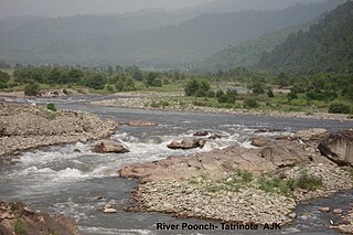
The Poonch River is a tributary of the Jhelum River that flows through Jammu and Kashmir in India, and Jammu and Kashmir in Pakistan.
Islamabad is located at 33.6844°N 73.0479°E at the edge of the Pothohar Plateau at the foot of the Margalla Hills in Islamabad Capital Territory. Its elevation is 507 metres (1,663 ft), the highest being 1,584 m. The modern capital and the ancient Gakhar city of Rawalpindi stand side by side and are commonly referred to as twin cities.
Dahana is a town of Khuiretta subdivision of Kotli District, Azad Kashmir, Pakistan. The town is on the Nail River, and has all the basic facilities, such as a health care center, banks, a library, schools, and transportation services.
Charhoi is a tehsil of Kotli District, Azad Kashmir, Pakistan. It is the largest city in Kotli district and is the headquarters of the district subdivision. A shrine of the poet Mian Muhammad Bakhsh is about 5 kilometers away from the main bazaar. Charhoi has a police station, post office, 3 big Jamia masjids and a 50 beds tehsil headquarter hospital, Charhoi Gala is main entrance of Charhoi city. Batowa, new batowa,Narakot, Chahwala, Dahmal Bazar, Damas and meda town is creation of a man name Juna Khanka Kotera, Sanyah are the main places around Charhoi. Charhoi is situated some 50 kilometers away from Mirpur City and around 30 kilometers from Khuiratta. Dahmal Nursery is a lush green place some 5 kilometers away, towards Khuiratta.
References
33°32′N73°58′E / 33.533°N 73.967°E
| | This Azad Kashmir location article is a stub. You can help Wikipedia by expanding it. |